Report on Paluweh (Indonesia) — February 1981
Scientific Event Alert Network Bulletin, vol. 6, no. 2 (February 1981)
Managing Editor: Lindsay McClelland.
Paluweh (Indonesia) Explosions and lava dome
Please cite this report as:
Global Volcanism Program, 1981. Report on Paluweh (Indonesia) (McClelland, L., ed.). Scientific Event Alert Network Bulletin, 6:2. Smithsonian Institution. https://doi.org/10.5479/si.GVP.SEAN198102-264150
Paluweh
Indonesia
8.32°S, 121.708°E; summit elev. 875 m
All times are local (unless otherwise noted)
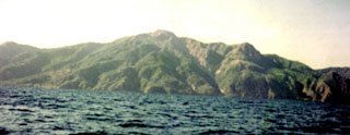
VSI provided further details about the intermittent explosive activity. The 40-m-diameter vent was formed during one of the early November eruptions and is situated on the upper NNE flank. Bombs from the 1-km-high eruption column on 9 November measured up to 60 cm in diameter. Beginning 18 January renewed activity was reported. A hot air wave was felt by the inhabitants of two E-flank villages. About 1,850 persons were evacuated from the danger zone. After the explosions on 31 January a new lava dome was observed in the crater. Activity declined gradually, and the volcano appeared to be normal again on 1 February at 1200. No casualties from Paluweh's November-January activity were reported.
Geological Summary. Paluweh volcano, also known as Rokatenda, forms the 8-km-wide island of Palu'e north of the volcanic arc that cuts across Flores Island. The broad irregular summit region contains overlapping craters up to 900 m wide and several lava domes. Several flank vents occur along a NW-trending fissure. The largest historical eruption occurred in 1928, when strong explosive activity was accompanied by landslide-induced tsunamis and lava dome emplacement. Pyroclastic flows in August 2013 resulted in fatalities.
Information Contacts: A. Sudradjat and L. Pardyanto, VSI.