Report on Pagan (United States) — April 1981
Scientific Event Alert Network Bulletin, vol. 6, no. 4 (April 1981)
Managing Editor: Lindsay McClelland.
Pagan (United States) Large tephra cloud; lava flows; 53 evacuated
Please cite this report as:
Global Volcanism Program, 1981. Report on Pagan (United States) (McClelland, L., ed.). Scientific Event Alert Network Bulletin, 6:4. Smithsonian Institution. https://doi.org/10.5479/si.GVP.SEAN198104-284170
Pagan
United States
18.13°N, 145.8°E; summit elev. 570 m
All times are local (unless otherwise noted)
A strong explosive eruption from North Pagan . . . began on 15 May. While reporting strong felt seismicity on the island, radio operator Pedro Castro suddenly announced at 0915 that the volcano was erupting. Communication was then cut off. An infrared image from the GMS at 1000 showed a very bright circular cloud about 80 km in diameter over the volcano. The cloud spread SE at about 70 km/hour, and by 1600 its maximum height was estimated at 13.5 km from satellite imagery. Weakening of activity was evident on the image returned at 1900, and on the next image, at 2200, feeding of the eruption cloud had stopped, with the proximal end of the cloud located about 120 km SE of the volcano. No additional activity has been detected on satellite images, but by 0400 the next morning, remnants of the plume had reached 10°N and 155°E.
Aircraft attempting to land on Pagan Island were prevented from doing so by the eruption. At 1235, pilots reported a mushroom cloud over the island and ashfall over its N and E ends. Ashfalls were also reported from Agrigan Island, 105 km NW. Additional pilot reports at 1410 indicated that the eruption was intensifying and that the cloud had reached more than 7 km altitude. UPI reported that aircraft crews flying past the island at two different (but unspecified) times saw ash rising to 10.5 and 18 km. The USN reported that aircraft crews saw lava flowing down the NE and NW flanks toward the sea, and about 2.5 km down the SW flank to within 1 km of the island's village and 0.5 km of the airstrip.
The Japanese merchant ship Hoyo Maru rescued all 53 persons on Pagan Island early 16 May. Only one minor injury was reported.
The USGS sent a 3-man team from the HVO to Pagan Island. When they overflew the island on 17 May at about 1200, the eruption had ended. Lava had advanced about 1 km down the NE and NW flanks from the summit. The SW flank flow had partially covered the airstrip, but had stopped before reaching the village.
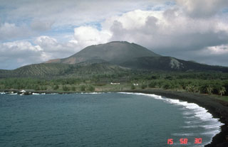
Geological Summary. Pagan Island, the largest and one of the most active of the Mariana Islands volcanoes, consists of two stratovolcanoes connected by a narrow isthmus. Both North and South Pagan stratovolcanoes were constructed within calderas, 7 and 4 km in diameter, respectively. North Pagan at the NE end of the island rises above the flat floor of the northern caldera, which may have formed less than 1,000 years ago. South Pagan is a stratovolcano with an elongated summit containing four distinct craters. Almost all of the recorded eruptions, which date back to the 17th century, have originated from North Pagan. The largest eruption during historical time took place in 1981 and prompted the evacuation of the sparsely populated island.
Information Contacts: F. Smigielski, NOAA/NESS; G. Telegadas, NOAA/Air Resources Lab (ARL); R. Tilling, USGS, Reston, VA; U.S. DOD; UPI.