Report on Pagan (United States) — May 1981
Scientific Event Alert Network Bulletin, vol. 6, no. 5 (May 1981)
Managing Editor: Lindsay McClelland.
Pagan (United States) Strong activity ends; USGS observations summarized
Please cite this report as:
Global Volcanism Program, 1981. Report on Pagan (United States) (McClelland, L., ed.). Scientific Event Alert Network Bulletin, 6:5. Smithsonian Institution. https://doi.org/10.5479/si.GVP.SEAN198105-284170
Pagan
United States
18.13°N, 145.8°E; summit elev. 570 m
All times are local (unless otherwise noted)
A USGS team of Norman Banks, Robert Koyanagi, and Kenneth Honma carried out ground observations, seismic monitoring, and deformation studies on Pagan Island 20-28 May. The material in quotes is excerpted from their report. Material not between quote marks was abstracted from their tabular data.
"A major eruption of North Pagan started 15 May, preceded by earthquakes first felt in late March or early April. The earthquakes (approximately 3/day) were strong enough to shake houses, and some were felt by persons out of doors; magnitudes were probably between 3 and 4. One resident visited the summit area 13 May and noted new ground cracks, sublimates, and increased gas emissions.
"On 15 May, the first of a series of closely-spaced earthquakes (at least 13 felt) began at 0745 and from descriptions of cracked concrete houses, one of the earthquakes (at 0825) probably exceeded magnitude 4. At 0915, residents heard a loud boom, followed immediately by the beginning of the eruption, first on the N flank then proceeding toward the S part of the summit area. The eruption apparently reached full intensity almost immediately, and lava flows were noted by residents very soon after the appearance of the ash/scoria column. Geologic observations show that ash eruption and lava emission took place simultaneously during most of the eruption.
"Airline and rescue pilots reported that the height of the eruption cloud exceeded 13 km, and Japan-based weather radar reported ash to heights of 18-20 km. Weather satellite images showed that the high-altitude ash cloud traveled SSE (6:4), but ash and scoria deposits on Pagan Island were thickest in the NW sector because of the prevailing SE winds at low altitude."
At 1930 there was a notable decrease in plume height and density. Activity remained weak the next day except for a brief period of vigorous ash ejection reported by the USN around noon. During an overflight between 1000 and 1030 on 18 May, only weak to moderate emission of blue fume was noted. Residents of Alamagan Island, 35 km SSE, reported "fire and smoke on the mountain" 19 May.
"Three vents, oriented about N-S, were active. The northernmost vent, about 1 km N of the summit, was probably the first to open; it built a scoria/ash cinder cone about 80 m high, 0.90 km2 in area, and about 36 x 106 m3 (or 12 x 106 m3 of magma, recalculated to a density of 3 g/cm3) in volume (figure 1). The central vent was in a notch about 100 m deep in the N rim of the old summit crater. This vent probably ejected most of the material in the large eruption cloud, and it fed flows that went N, NNE, and W. The third and southernmost vent was in a notch about 80 m deep in the S rim of the old summit. This vent fed flows that moved S."
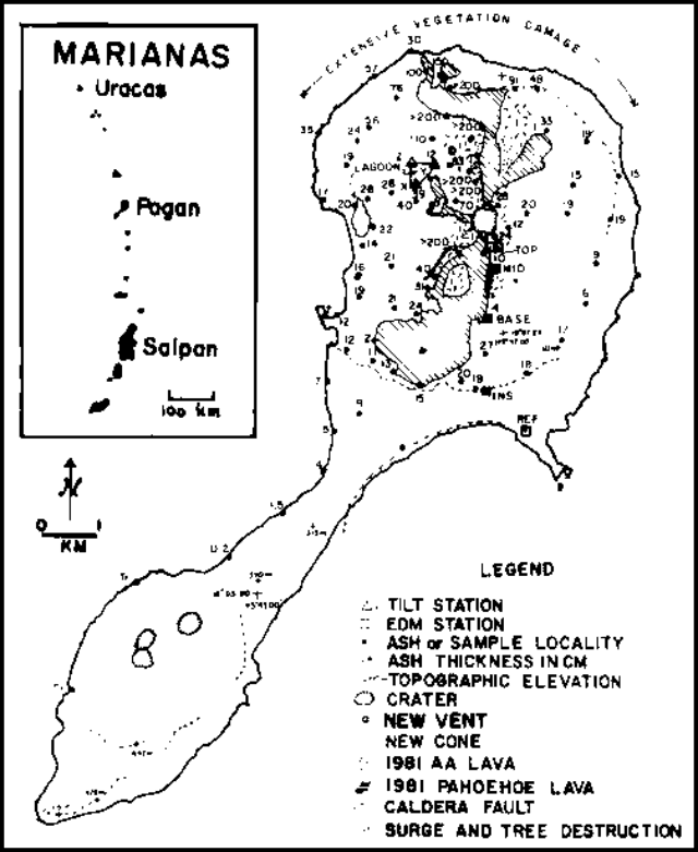 |
Figure 1. Sketch map of Pagan showing distribution of the 15 May 1981 eruption products. Courtesy of the USGS. |
The USGS team observed intermittent activity during 8 days of field work on Pagan Island. An increase in harmonic tremor level and the number of discrete higher frequency events began 1-2 hours before the extrusion of minor aa lava flows from the S summit vent late 21-early 22 May, and late 23 May. A similar increase in seismicity during the midmorning of 24 May was followed by ash emission from both the N and S summit vents that lasted from early afternoon through the evening. As ash emission was decreasing during the evening of 24 May, extrusion of a small amount of aa lava occurred; lava extrusion also occurred during the evening and predawn hours of 25 and 26 May. Eruptive activity was then limited to minor fuming until USGS personnel left Pagan Island 28 May.
"The volume of eruptive products ejected through 28 May exceeded 50 x 106 m3, and a large part of the island's arable land was covered by lava flows, and airfall ash and scoria. Lava flows were predominantly aa and ranged from 3 to 30 m in thickness. Fortunately, extremely devastating phenomena such as widespread pyroclastic flows did not take place. Lithic blocks and juvenile bombs as large as 1 m in diameter were thrown more than 2 km from the summit onto the N flank, and base surge phenomena, evidenced by low-amplitude (4-20 cm) dune and antidune features and preferential upslope tree damage, took place in restricted corridors down to elevations of 200 m on the N and S slopes.
"The events of 15 May caused no injuries to residents, but some livestock were killed outright, and others were starving because of extensive destruction of vegetation. However, the present breaches on the N and S rims of the crater could channel potentially destructive pyroclastic flows into narrow corridors N and S of the summit. Such channeling may have occurred on 15 May and could occur again, even during the current eruptive cycle.
"Ash and scoria deposits on the island, constituted about 4 x 10⁶ m3 of magma (recalculated to a density of 3 g/cm3) and exceeded 2 m in thickness NW of the summit crater. An unknown volume of ash and scoria was deposited at sea and composed the ash plume that extended S of Guam. The longest lava flow (2.8 km), that issued from the S vent covered 2.5 km2 and had a volume of about 15 x 106 m3. The N summit vent fed flows (1 km long, 0.2 km2 area, 1.0 x 10⁶ m3 volume) that spilled over the summit crater on the W and stopped 100 m short of the inner lagoon; it also fed very voluminous flows that advanced N, dissecting and carrying away much of the material in the cinder cone around the vent on the N flank. The NE lobe of these northern flows traveled 1.5 km, covered an area of about 0.2 km2, and contained 2 x 10⁶ m3 of lava. The N lobe traveled 3.5 km, locally exceeded 30 m in thickness, covered an area of about 1.3 km2, and had a volume of about 25 x 106 m3. The several lava flow and ash-ejecting events after 15 May were all of minor volume.
"Six gas samples were collected from four cracks that opened during the 15 May eruption, and 1 sample of airfall scoria was fused and analyzed by electron microprobe by John Sinton (University of Hawaii). Preliminary analyses of the gas samples by Paul Greenland (HVO) suggest that they contain a large portion of air (mostly introduced into the vent system through the porous volcanic edifice). When compared with gases of Kīlauea (Hawaii) and Mt. St. Helens (Washington), the Pagan gas had low amounts of SO2 and high amounts of H2, CO, CH4, and COS. The scoria sample was more or less typical of basalt of northern Marianas volcanoes (table 1). Hand-specimen examination indicates that the 1981 basalt contains few (1-7%) phenocrysts (1-2 mm long) that are dominantly plagioclase and clinopyroxene.
Table 1. Chemical analyses of Pagan samples. 1981 values are from microprobe analyses of a fused sample by John Sinton, University of Hawaii; the analyses of 1925 flows are from Larson and others (1975).
| Element | 1981 | 1925 (max) | 1925 (min) |
| SiO2 | 52.0 | 50.3 | 50.1 |
| Al2O3 | 15.7 | 18.1 | 17.9 |
| FeO | 11.3 | 9.6 | 8.9 |
| MgO | 5.0 | 4.8 | 4.8 |
| CaO | 9.9 | 10.8 | 10.6 |
| Na2O | 2.4 | 2.7 | 2.5 |
| K2O | 0.65 | 0.72 | 0.70 |
| TiO2 | 0.95 | 1.16 | 0.98 |
| P2O5 | 0.21 | 0.16 | 0.07 |
| MnO | 0.22 | 0.21 | 0.03 |
"A tilt monitor was established 21 May on the inner lagoon to measure possible changes of lake level around the shoreline and tilt of the lakebed. During the 8-day monitoring period, the lake level dropped regularly at a rate of about 24 mm/day, either because of tidal changes, slow drainage of the lake, water evaporation, or uplift of that part of the island. Continued drainage of the lake or increases in temperature of the lake water would cause concern, because such changes could indicate that ground water might be heating in response to the proximity of hot rock in the volcanic edifice. The overall trend of the tilt changes observed can be interpreted in terms of a possible inflation center NE of the lake near the N flank vent. In addition, fluctuations took place that could either be measurement noise or, if real, be associated with the largest eruptive events during our residence on the island (24 May ash event and 25 May lava event).
"A segmented EDM array was installed on the S flank as an additional deformation monitor. In general, changes above "noise" level were not seen in the lines measured from the instrument (INS, figure 1) to the three nearest stations, but station TOP (at elevation 540 m) moved steadily southward, 66 mm in 6 days. This movement could have resulted from inflation of the summit due to intrusion of a shallow magma body, gravitational instability of the summit area, or right-lateral movement on the N-S fissure system that formed during the eruption.
"Seismic monitoring 20-28 May showed continuous harmonic tremor indicating movement of magma a few kilometers beneath the surface, and short bursts of high-frequency signals, indicating intermittent extrusive events such as degassing and low-level lava fountaining. The ongoing harmonic tremor suggests that more secondary eruptive activity may take place.
"At the same time, no significant earthquake activity was detected, indicating no prominent buildup of stresses typically associated with activities prior to a major explosive eruption. However, the deformation survey indicated possible swelling of the volcano, which may lead to an increase in future microearthquake activity and eventually to an eruptive event more significant than those of 20-28 May."
Reference. Larson, E.E., Reynolds, R.L., Merrill, R., Levi, S., and Ozima, M., 1975, Major-element petrochemistry of some extrusive rocks from the volcanically active Mariana Islands: BV, v. 38, p. 361-377.
Further References. Banks, N.G., Koyanagi, R.Y., Sinton, J.M., and Honma, K.T., 1984, The eruption of Mt. Pagan volcano, Mariana Islands, 15 May 1981: JVGR, v. 22, p. 225-270.
Sawada, Y., 1983, Analysis of eruption clouds by the 1981 eruptions of Alaid and Pagan volcanoes with GMS images: Papers in Meteorology and Geophysics, v. 34, p. 307-324.
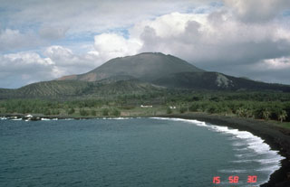
Geological Summary. Pagan Island, the largest and one of the most active of the Mariana Islands volcanoes, consists of two stratovolcanoes connected by a narrow isthmus. Both North and South Pagan stratovolcanoes were constructed within calderas, 7 and 4 km in diameter, respectively. North Pagan at the NE end of the island rises above the flat floor of the northern caldera, which may have formed less than 1,000 years ago. South Pagan is a stratovolcano with an elongated summit containing four distinct craters. Almost all of the recorded eruptions, which date back to the 17th century, have originated from North Pagan. The largest eruption during historical time took place in 1981 and prompted the evacuation of the sparsely populated island.
Information Contacts: N. Banks, R. Koyanagi, and K. Honma, HVO.