Report on Farallon de Pajaros (United States) — September 1981
Scientific Event Alert Network Bulletin, vol. 6, no. 9 (September 1981)
Managing Editor: Lindsay McClelland.
Farallon de Pajaros (United States) Normal fuming and discolored water
Please cite this report as:
Global Volcanism Program, 1981. Report on Farallon de Pajaros (United States) (McClelland, L., ed.). Scientific Event Alert Network Bulletin, 6:9. Smithsonian Institution. https://doi.org/10.5479/si.GVP.SEAN198109-284140
Farallon de Pajaros
United States
20.546°N, 144.893°E; summit elev. 337 m
All times are local (unless otherwise noted)
"A 16 July USN flight also covered the Quaternary volcanoes of the Marianas. Fuming and discolored water were observed at Farallon de Pajaros but were not anomalous conditions."
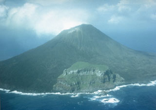
Geological Summary. The small 2-km-wide island of Farallon de Pajaros (also known as Uracas) is the northernmost and most active volcano of the Mariana Islands. Its relatively frequent eruptions dating back to the mid-19th century have caused the andesitic volcano to be referred to as the "Lighthouse of the western Pacific." The symmetrical, sparsely vegetated summit is the central cone within a small caldera cutting an older edifice, remnants of which are seen on the SE and southern sides near the coast. Flank fissures have fed lava flows that form platforms along the coast. Eruptions have been recorded from both summit and flank vents.
Information Contacts: N. Banks, HVO.