Report on Nyamulagira (DR Congo) — January 1982

Scientific Event Alert Network Bulletin, vol. 7, no. 1 (January 1982)
Managing Editor: Lindsay McClelland.
Nyamulagira (DR Congo) 30 km lava flows; heavy tephra falls
Please cite this report as:
Global Volcanism Program, 1982. Report on Nyamulagira (DR Congo) (McClelland, L., ed.). Scientific Event Alert Network Bulletin, 7:1. Smithsonian Institution. https://doi.org/10.5479/si.GVP.SEAN198201-223020
Nyamulagira
DR Congo
1.408°S, 29.2°E; summit elev. 3058 m
All times are local (unless otherwise noted)
A fissure eruption from the SE foot of Nyamuragira started during the night of 25-26 December. Ground observers first noted activity about 0130 on 26 December, but satellite data indicated that the eruption may have begun as much as 2 hours earlier. According to the satellite data, lava flowed slightly N of E for 6-8 km, then turned more to the N. By 0100 on 26 December, the flow front appeared to be 12-14 km from the vents, but its advance had slowed substantially from the initial rate of 20-24 km/hour to less than 6 km/hour.
The source of the eruption was a 1.5-km-long zone of en echelon fissures, trending roughly N70°W at 2170 m altitude (figure 3). Lava initially fountained from the entire length of the fissure zone, but activity was soon confined to its SE (and lowest) end. After a few days, 400-m-wide lava flows had advanced as much as 30 km, destroying forest in Virunga National Park. A plume of scoria and ash rose 6 km or slightly more. A large quantity of tephra, including Pele's hairs and tears, fell within 25 km of the vents, damaging vegetation and killing many animals (see below).
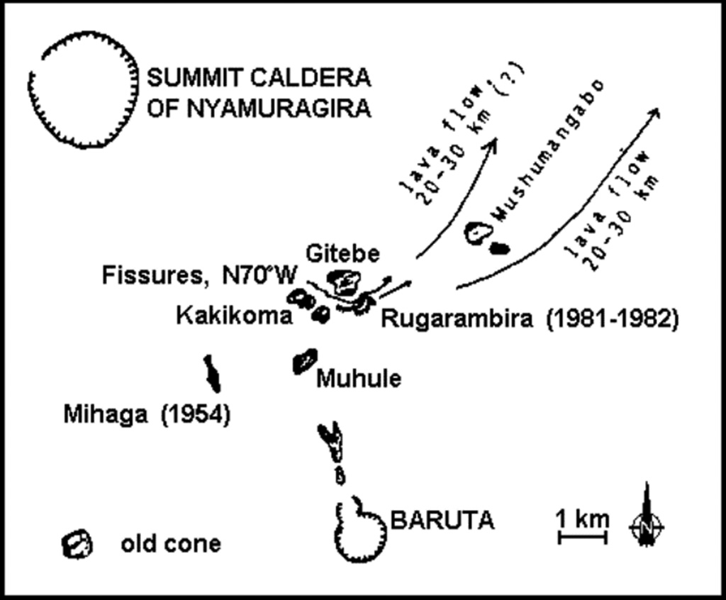 |
Figure 3. Sketch map showing 1981-82 eruption fissures, directions of lava flows, and surrounding older cones. Courtesy of K. Krafft. |
When Katia Krafft began field work at the eruption site 3 January, a pair of lava fountains, 100-200 m high, was emerging from a small lava lake in the asymmetrical cone that had formed over the SE end of the fissure zone. The E wall of the cone, near the dominant vents, was about 100 m high, but the W wall was only about 30 m high. An aa lava flow a few meters wide cascaded from a breach in one wall of the cone and moved downslope at ~20 km/hour, but within 50 m had widened to 10 m and slowed to 7 km/hour as it passed through a channel between 5-m-high blocks. A scoria column rose about 1 km. Fountaining became more vigorous about 2200 on 3 January, but had declined to its previous level by the next morning. A second increase in lava fountaining, to as much as 200 m height, began suddenly about 1300 on 4 January. Scoria up to 5 cm in diameter fell 3 km from the vent, as during the first week of the eruption. Explosions occurred every few seconds during the early afternoon. Shock waves from explosions occasionally shook tents 3 km away, but these could not be correlated with increases in lava fountain heights. Strombolian activity from a third vent, in the NE part of the cone, began abruptly during the early evening. Dark plumes of ash and scoria were occasionally ejected from this vent.
Lava fountaining was much weaker 5 January, but the rate of effusion of the lava flow remained constant that day, then increased during the evening of 6 January. The lava cascade through the breach in the crater wall widened to at least 10 m and lava flowed away at 20 km/hour, but a crust formed over the flow 50 m from the crater. Incandescent fissures appeared in the NE wall of the cone. During the next 24 hours a large quantity of lava was discharged, forming a mass of blocks in a steep 10-m-high crest at the edge of the flow. A small flow, 1-2 m thick, moved toward the E then turned NE for about 1 km; the lava formed slabs near the vent then changed to an aa flow downslope.
A team of Japanese seismologists measured strong seismic activity 6-9 January, then a decrease on the 10th. Residents of Goma, Zaire (30 km from the volcano) and Kigali (the capital of Rwanda, ~120 km away) felt a strong earthquaket 9 January at 1927, but the event was not noticed by geologists near the volcano and was not recorded by the Worldwide Seismic Stations Network (WWSN). The effusion rate and speed of the lava flow remained unchanged 9-11 January, but the height of the lava fountains decreased. The eruption ended during the night of 14-15 January.
Heavy tephra falls occurred N, E, and S of the cone. By the time the eruption ended, 1.5 m of ash and scoria had fallen within 1.5 km of the vents and deposits were more than 0.5 m thick 3-4 km away; only a few cm of tephra fell W of the vents. All shrubs and trees in the area were stripped of leaves and bark. Many birds and rodents similar to small rabbits were killed in the tephra fall area. Within about a dozen km of the cone, the eruption created a microclimate characterized by numerous violent thunderstorms with torrential rains and hail during Krafft's eight days of observations.
The scoria was very vesicular and was not found in large fragments because it exploded upon striking the ground. A few bombs weighing 1-2 kg were thrown as far as 100 m from the cone during Krafft's field work. The lava was a basanite with numerous augite and olivine phenocrysts. Numerous xenoliths, coated with a thin glaze of lava, were ejected during the eruption, both by the explosive activity (in fragments 5-20 cm in diameter) and in the lava flows. The xenoliths were whitish to yellowish, and spongy, consisting primarily of büchite (altered quartzite) and porcellanite (altered argillaceous schist).
[Later analysis of Nimbus-7 satellite data by Krueger and associates revealed the emission of a large SO2 plume at the start of the eruption at the end of 1981. This plume is thought to be the source of the early 1982 "Mystery Cloud" of stratospheric aerosols detected by atmospheric scientists before the much larger March-April 1982 El Chichón eruption.]
Further Reference. Kampunzu, A. B., Lubala, R. T., Brousse, R., and others, 1984, Sur l'eruption du Nyamulagira de Decembre 1981 a Janvier 1982: Cone et Coulee du Rugarambiro (Kivu, Zaire): BV, v. 47, p. 79-105.
Geological Summary. Africa's most active volcano, Nyamulagira (also known as Nyamuragira), is a massive high-potassium basaltic shield about 25 km N of Lake Kivu and 13 km NNW of the steep-sided Nyiragongo volcano. The summit is truncated by a small 2 x 2.3 km caldera that has walls up to about 100 m high. Documented eruptions have occurred within the summit caldera, as well as from the numerous flank fissures and cinder cones. A lava lake in the summit crater, active since at least 1921, drained in 1938, at the time of a major flank eruption. Recent lava flows extend down the flanks more than 30 km from the summit as far as Lake Kivu; extensive lava flows from this volcano have covered 1,500 km2 of the western branch of the East African Rift.
Information Contacts: K. Krafft, Cernay; N. Zana, IRS.