Report on Grimsvotn (Iceland) — February 1982
Scientific Event Alert Network Bulletin, vol. 7, no. 2 (February 1982)
Managing Editor: Lindsay McClelland.
Grimsvotn (Iceland) Large jökulhlaup from beneath Vatnajökull glacier
Please cite this report as:
Global Volcanism Program, 1982. Report on Grimsvotn (Iceland) (McClelland, L., ed.). Scientific Event Alert Network Bulletin, 7:2. Smithsonian Institution. https://doi.org/10.5479/si.GVP.SEAN198202-373010
Grimsvotn
Iceland
64.416°N, 17.316°W; summit elev. 1719 m
All times are local (unless otherwise noted)
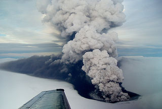
"A glacier burst (jökulhlaup) from Grímsvötn caldera in Vatnajökull glacier started 28 January. It increased slowly, with a discharge on 4 February of 420 m3/s. It culminated on 11 February at 2,000 m3/s and ended 21 February. Total discharge is estimated at 1.3 km3 and the lowering of the ice level in the caldera at about 50 m. The volume of the last jökulhlaup from Grímsvötn, in September 1976, was estimated at 2.4 km3 and that of 1972 at 3.2 km3."
[Most of the] documented jökulhlaups from Vatnajökull between 1332 and 1934 were probably caused by eruptions of Grímsvötn, under the glacier. Since then, Icelandic volcanologists believe that steady heat production from Grímsvötn has caused a gradual buildup of meltwater beneath the glacier. Occasional sudden failures have produced large outflows from beneath Vatnajökull.
Geological Summary. Grímsvötn, Iceland's most frequently active volcano in recent history, lies largely beneath the vast Vatnajökull icecap. The caldera lake is covered by a 200-m-thick ice shelf, and only the southern rim of the 6 x 8 km caldera is exposed. The geothermal area in the caldera causes frequent jökulhlaups (glacier outburst floods) when melting raises the water level high enough to lift its ice dam. Long NE-SW-trending fissure systems extend from the central volcano. The most prominent of these is the noted Laki (Skaftar) fissure, which extends to the SW and produced the world's largest known historical lava flow in 1783. The 15 km3 basaltic Laki lavas were erupted over 7 months from a 27-km-long fissure system. Extensive crop damage and livestock losses caused a severe famine that resulted in the loss of one-fifth of the population of Iceland.
Information Contacts: S. Thorarinsson and H. Björnsson, Univ. of Iceland; K. Grönvold, NVI; S. Rist, National Energy Authority.