Report on Pagan (United States) — March 1983
Scientific Event Alert Network Bulletin, vol. 8, no. 3 (March 1983)
Managing Editor: Lindsay McClelland.
Pagan (United States) Tephra deposits suggest 4-7 eruptions since May 1981
Please cite this report as:
Global Volcanism Program, 1983. Report on Pagan (United States) (McClelland, L., ed.). Scientific Event Alert Network Bulletin, 8:3. Smithsonian Institution. https://doi.org/10.5479/si.GVP.SEAN198303-284170
Pagan
United States
18.13°N, 145.8°E; summit elev. 570 m
All times are local (unless otherwise noted)
"A team of four HVO scientists, five scientists from the USGS Water Resources Division, plus Civil Defense and other government officials from the Commonwealth of the North Mariana Islands visited Pagan 5-15 March.
"There were two very minor ash eruptions on 7 and 15 March; ashfall was confined to the summit cone. During the remainder of the visit, activity was limited to degassing. The gases were essentially atmospheric in composition, much different than the May 1981 gases, which had a high magmatic component. Seismic monitors showed varying amounts of B-type events and harmonic tremor. More numerous and stronger seismic events preceded the ash eruptions of 7 and 15 March.
"HVO scientists established a second EDM array (one had been installed in May 1981) and a tilt network, and installed a seismic event counter and two-component tiltmeter. Both EDM arrays showed minor deflation 5-15 March. Reoccupation of the original EDM line showed that 25 cm of net inflation had occurred on the higher slopes of the volcano between May 1981 and March 1983, but the lack of other measurements between those dates prevented determination of shorter-term deformation trends.
"Scientists from the Water Resources Division installed equipment to transmit data from the two-component tiltmeter (including periodic temperature measurements), the seismic event counter, and a rain gauge to Hawaii via the GOES West satellite. They also performed a water resource evaluation and sampled volcanic gases.
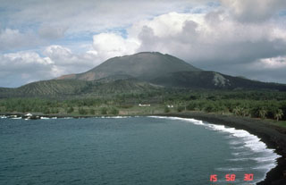
"Stratigraphy of the tephra deposits indicated that Pagan had erupted at least four and perhaps as many as seven times since May 1981. The volume of the post-May 1981 tephra deposits is minor in comparison to that of the May 1981 deposit. It is difficult to assign eruption dates to each tephra layer because of the sporadic nature of observations on the island. However, it is probable that a single lava flow and one of the tephra layers was produced on 11 June, 1981 (6:6). Other eruptions were observed in November 1981 (6:11) and January through February 1982 (7:2). The date of emplacement of the uppermost and thickest tephra layers is uncertain. However, comparison of December 1982 aerial photographs with those taken in August 1982 suggested that these layers were emplaced during that interval. In addition, during late September-October 1982, residents of Saipan (roughly 300 km to the S) reported a dark cloud, similar to the one ejected in May 1981, drifting to the S.
"The most recent eruptive products were slightly richer in phenocrysts than products of the May 1981 eruption. A preliminary microprobe analysis indicated that February 1982 eruption material was less differentiated than that of May 1981 but similar in composition to the 1925 magma (6:6).
"The activity seen by USN personnel on 10 December 1982 was much less intense than that of March 1983. The burning seen along the S and SW slopes was on another edifice on the opposite (S) end of the island, and was due to a brush fire, unrelated to eruptive activity.
"Early in 1982, there was speculation that Pagan may have been the source for the 'Mystery Cloud' of volcanic aerosols in the stratosphere (7:1-3). The volume of individual tephra layers does not by itself suggest that Pagan was the source of the aerosols. However, they contain a large fraction of lithic material, suggestive of powerful gas jetting and erosion of the vent; lidar studies indicated that the source was at the approximate latitude of Pagan; and Pagan is the only volcano thought to have been in eruption at that latitude and at that time. Thus, at present, Pagan remains the best possible source for the 'Mystery Cloud' of early 1982." [Later work on Nimbus 7 satallite data by Arlin Krueger revealed a large SO2 cloud originating in the vicinity of Nyamuragira Volcano, Zaire in late December 1984. This eruption is now thought to be a more likely source for the `Mystery Cloud.']
Geological Summary. Pagan Island, the largest and one of the most active of the Mariana Islands volcanoes, consists of two stratovolcanoes connected by a narrow isthmus. Both North and South Pagan stratovolcanoes were constructed within calderas, 7 and 4 km in diameter, respectively. North Pagan at the NE end of the island rises above the flat floor of the northern caldera, which may have formed less than 1,000 years ago. South Pagan is a stratovolcano with an elongated summit containing four distinct craters. Almost all of the recorded eruptions, which date back to the 17th century, have originated from North Pagan. The largest eruption during historical time took place in 1981 and prompted the evacuation of the sparsely populated island.
Information Contacts: N. Banks, HVO.