Report on Piton de la Fournaise (France) — December 1983

Scientific Event Alert Network Bulletin, vol. 8, no. 12 (December 1983)
Managing Editor: Lindsay McClelland.
Piton de la Fournaise (France) Lava emission continues; volcanic tremor
Please cite this report as:
Global Volcanism Program, 1983. Report on Piton de la Fournaise (France) (McClelland, L., ed.). Scientific Event Alert Network Bulletin, 8:12. Smithsonian Institution. https://doi.org/10.5479/si.GVP.SEAN198312-233020
Piton de la Fournaise
France
21.244°S, 55.708°E; summit elev. 2632 m
All times are local (unless otherwise noted)
"The eruption was continuing as of 5 January, but the effusive and explosive activity and tremor amplitude had decreased. A rough estimate of the total magma output through 5 January was 10 x 106 m3, about double the volume that had reached the surface by 14 December (figure 7).
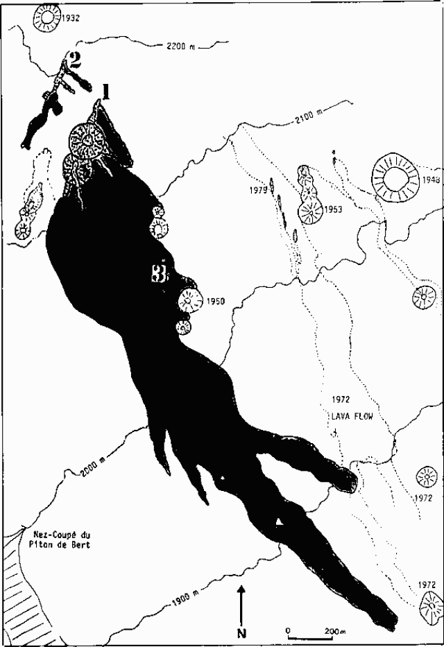 |
Figure 7. Map showing the 1983 lava flows (shaded) and eruption fissures at Piton de la Fournaise as of 14 December. Older craters and fissures are dated and the 1972 lava flow is outlined with dots. Activity stopped on 4 December 1983 at about 1400 along fissure zone 2 and about 0700 the next day along fissure 3. Courtesy of OVPDLF. |
"A resurvey of the deformation networks during the days following the onset of the eruption has shown that ground deformation has taken place in the summit area. Tilt and distance measurements indicate an inflation centered S of the summit craters with a shallow focus. Records from a continuously recording strainmeter in the summit area indicate that the major part of the ground deformation happened within 1/2-3/4 hour (figure 8). [Rapid deformation started about two hours before the eruption and just after the beginning of the seismic swarm associated with the intrusion toward the surface (figure 9)]. No other significant ground deformation has been observed during the course of the eruption through 21 December. Since the beginning of the eruption, the only recorded seismic activity has been volcanic tremor with amplitude that varied with time."
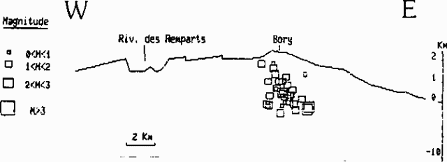 |
Figure 8. Extension (in millimeters) detected at Piton de la Fournaise on 4 December 1983 between midnight and 1400 by a continuously recording strainmeter in the summit area. Courtesy of OVPDLF. |
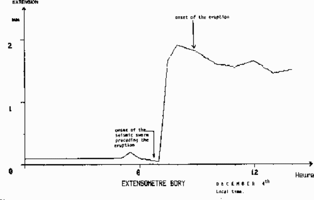 |
Figure 9. Pre-eruption seismic cross-section through the summit of Piton de la Fournaise, with hypocenters and magnitudes between 20 November and the onset of the pre-eruption swarm of 4 December 1983. The three initial swarm events are also shown. Courtesy of OVPDLF. |
Geological Summary. Piton de la Fournaise is a massive basaltic shield volcano on the French island of Réunion in the western Indian Ocean. Much of its more than 530,000-year history overlapped with eruptions of the deeply dissected Piton des Neiges shield volcano to the NW. Three scarps formed at about 250,000, 65,000, and less than 5,000 years ago by progressive eastward slumping, leaving caldera-sized embayments open to the E and SE. Numerous pyroclastic cones are present on the floor of the scarps and their outer flanks. Most recorded eruptions have originated from the summit and flanks of Dolomieu, a 400-m-high lava shield that has grown within the youngest scarp, which is about 9 km wide and about 13 km from the western wall to the ocean on the E side. More than 150 eruptions, most of which have produced fluid basaltic lava flows, have occurred since the 17th century. Only six eruptions, in 1708, 1774, 1776, 1800, 1977, and 1986, have originated from fissures outside the scarps.
Information Contacts: J. Lenat, A. Bonneville, P. Tarits, and H. Delorme, OVPDLF; P. Bachelery and J. Bougeres, Univ. de la Réunion.