Report on Piton de la Fournaise (France) — June 1985

Scientific Event Alert Network Bulletin, vol. 10, no. 6 (June 1985)
Managing Editor: Lindsay McClelland.
Piton de la Fournaise (France) Fissure eruption follows seismicity and deformation
Please cite this report as:
Global Volcanism Program, 1985. Report on Piton de la Fournaise (France) (McClelland, L., ed.). Scientific Event Alert Network Bulletin, 10:6. Smithsonian Institution. https://doi.org/10.5479/si.GVP.SEAN198506-233020
Piton de la Fournaise
France
21.244°S, 55.708°E; summit elev. 2632 m
All times are local (unless otherwise noted)
"An eruption began on 14 June at 1604 on the SW flank of the central cone (figure 10), just as in the July 1979, February 1981, December 1983, and January 1984 eruptions. The main eruptive fissure, oriented 230°, was ~1 km long and composed of four main en-echelon fractures. A small fissure oriented 330° was located NW of the summit. The NW fissure and the upper part of the SW fissure were active for 2-6 hours after the beginning of the eruption. Activity stopped on the lower part of the SW fissure on 15 June at about 1600. Flows were emitted all along the fissure, the longest extending ~2 km from it. No calculation of emitted volume has yet been made, but a crude approximation is 1 x 10⁶ m3.
 |
Figure 10. Sketch map of the central and south parts of the Piton de la Fournaise caldera, showing lava flows from the 1983-84 and 1985 eruptions, and vents from earlier eruptions. Courtesy of OVPDLF. |
"This eruption was preceded by a 30-day pre-eruptive seismic crisis and by a 40-minute intrusive seismic swarm. Seismicity had been at background levels since the end of the 1983-84 eruption. The pre-eruptive seismic crisis began on 15 May and the number of recorded earthquakes has increased since then (figure 11). All were located beneath the summit at a mean depth of 1.5-2.5 km. The duration of the pre-eruptive seismic crisis and the number of events have been greater than for the December 1983 eruption, but the location of events has been the same.
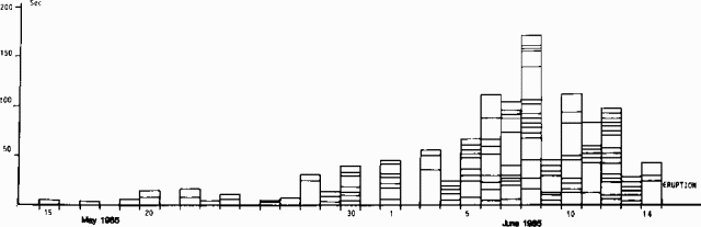 |
Figure 11. Chronology of the 1985 pre-eruption seismic crisis at Piton de la Fournaise. Each box represents one earthquake. Box heights represent earthquake durations. Courtesy of OVPDLF. |
"Since the end of the 1983-84 eruption, the deformation has been small, which could be interpreted as a relaxation of the area that had undergone large displacements during the two intrusive crises related to the 4 December 1983 and 18 January 1984 outbreaks. A pattern of inflation of the central area has been measured since May 1985. This inflation developed during the pre-eruptive crisis and was in the range of 20-50 µrads at the dry-tilt stations located near the summit. Inflation was not seen at the stations more than 2-3 km from the summit.
"Figure 12 shows the chronology of seismicity 14-15 June and detailed plots of the 40-minute intrusive period. As the intrusion approached the surface, local surface movements occurred, as shown by strainmeters across an open fissure and by the tiltmeter ~200 m from the eruptive fissure.
 |
Figure 12. Seismicity at Piton de la Fournaise, 14-15 June 1985. Top, relative amplitude of harmonic tremor at BOR station, ~200 m from the fissure, 14-15 June; center, cumulative duration of seismic activity (in seconds) during 5-minute intervals, 14 June between 1200 and 1700 hours; bottom, tiltmeter and strainmeter data at BOR station, 14 June, 1200-1700. Arrows at top and center mark the start of the eruption, as does the right-hand vertical dashed line in the tilt/strain section of the figure. Courtesy of OVPDLF. |
"The lava of the 14-15 June eruption is a transitional aphyric basalt with a composition (table 2) similar to that of the 1983-84 basalt. This supports the hypothesis that the shallow magma chamber could not have been replenished before this eruption.
Table 2. Composition of two samples of the 14-15 June 1985 basalt from Piton de la Fournaise. Courtesy of OVPDLF.
| Element | Sample A | Sample B |
| SiO2 | 49.50 | 49.20 |
| Al2O3 | 14.60 | 14.60 |
| Fe2O3 | 4.14 | 4.89 |
| FeO | 7.53 | 6.18 |
| MgO | 7.10 | 7.10 |
| CaO | 11.60 | 11.60 |
| Na2O | 2.50 | 2.50 |
| K2O | 0.80 | 0.80 |
| TiO2 | 2.90 | 2.90 |
| MnO | 0.18 | 0.18 |
| Total | 100.85 | 100.58 |
Geological Summary. Piton de la Fournaise is a massive basaltic shield volcano on the French island of Réunion in the western Indian Ocean. Much of its more than 530,000-year history overlapped with eruptions of the deeply dissected Piton des Neiges shield volcano to the NW. Three scarps formed at about 250,000, 65,000, and less than 5,000 years ago by progressive eastward slumping, leaving caldera-sized embayments open to the E and SE. Numerous pyroclastic cones are present on the floor of the scarps and their outer flanks. Most recorded eruptions have originated from the summit and flanks of Dolomieu, a 400-m-high lava shield that has grown within the youngest scarp, which is about 9 km wide and about 13 km from the western wall to the ocean on the E side. More than 150 eruptions, most of which have produced fluid basaltic lava flows, have occurred since the 17th century. Only six eruptions, in 1708, 1774, 1776, 1800, 1977, and 1986, have originated from fissures outside the scarps.
Information Contacts: J. Lenat, OVPDLF; P. Bachelery, Univ. de la Réunion; A. Bonneville, Univ. du Languedoc; G. Boudon, Obs. Volc. de la Mt. Pelée; M. Halbwachs, Univ. de Chambéry; M. Kasser, IGN, Paris; A. Nercessian, IPGP, Paris; R. Vie le Sage, DRM, Paris.