Report on Piton de la Fournaise (France) — September 1985

Scientific Event Alert Network Bulletin, vol. 10, no. 9 (September 1985)
Managing Editor: Lindsay McClelland.
Piton de la Fournaise (France) Fissure eruption follows inflation and earthquake swarm
Please cite this report as:
Global Volcanism Program, 1985. Report on Piton de la Fournaise (France) (McClelland, L., ed.). Scientific Event Alert Network Bulletin, 10:9. Smithsonian Institution. https://doi.org/10.5479/si.GVP.SEAN198509-233020
Piton de la Fournaise
France
21.244°S, 55.708°E; summit elev. 2632 m
All times are local (unless otherwise noted)
A very short seismic crisis began on 6 September at 1408. As for the June and August eruptive episodes, seismic events were centered under Dolomieu and Soufrière, at 1 km depth (10:5-8). After 30 shallow summit seismic events, three eruptive fissures opened at 1520. The first fissure (near Soufrière) was 50 m long and continued erupting for 2 hours. The second, 250 m long, opened inside the Dolomieu summit crater and erupted until 0500 the next morning. The third, E-oriented and 500 m long, opened on the E flank of Dolomieu (figure 14). [As of 7 September at 1400, the eruption was continuing from this fissure and the lava flow along the Grandes Pentes had reached 1,000 m altitude (10:08)].
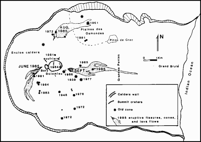 |
Figure 14. Provisional map of the 1985 eruptive fissures and lava flows, as of 30 September. Courtesy of OVPDLF and the Université de la Réunion. |
Eruptive activity was then limited to Dolomieu's E flank fissure at 2,200 m altitude. A major cone (Thierry crater) has formed, emitting lava that advanced to an altitude of 550 m, following 1977 flows. After a few days, active flow fronts reached only 1,700 m altitude, ~2 km from Thierry crater. The upper part of the fissure system was then reactivated 15-17 September, emitting a small amount of scoria and a small lava flow. Since 20 September, lava flows have been emitted through a tube at 1,900 m altitude. The volume of the lava was estimated to be 14-17 x 106 m3 of 30 September. The lavas are basalts with variable amounts of olivine phenocrysts. Major degassing took place, rich in sulfur compounds.
Before the 6 September eruption, a small summit inflation was recorded. Geodetic and leveling measurements show that horizontal and vertical deformation related to the new fissures reached 40 cm, coinciding with inflation of the E zone of Dolomieu. Deformation has been recorded in the whole W side of the Enclos caldera. During the eruption, no significant movement was recorded, except on the E coast.
Geological Summary. Piton de la Fournaise is a massive basaltic shield volcano on the French island of Réunion in the western Indian Ocean. Much of its more than 530,000-year history overlapped with eruptions of the deeply dissected Piton des Neiges shield volcano to the NW. Three scarps formed at about 250,000, 65,000, and less than 5,000 years ago by progressive eastward slumping, leaving caldera-sized embayments open to the E and SE. Numerous pyroclastic cones are present on the floor of the scarps and their outer flanks. Most recorded eruptions have originated from the summit and flanks of Dolomieu, a 400-m-high lava shield that has grown within the youngest scarp, which is about 9 km wide and about 13 km from the western wall to the ocean on the E side. More than 150 eruptions, most of which have produced fluid basaltic lava flows, have occurred since the 17th century. Only six eruptions, in 1708, 1774, 1776, 1800, 1977, and 1986, have originated from fissures outside the scarps.
Information Contacts: H. Delorme and J. Delarue, OVPDLF; P. Bachelery, Univ. de la Réunion.