Report on Nevado del Ruiz (Colombia) — October 1985

Scientific Event Alert Network Bulletin, vol. 10, no. 10 (October 1985)
Managing Editor: Lindsay McClelland.
Nevado del Ruiz (Colombia) Lahars triggered by explosions kill more than 20,000
Please cite this report as:
Global Volcanism Program, 1985. Report on Nevado del Ruiz (Colombia) (McClelland, L., ed.). Scientific Event Alert Network Bulletin, 10:10. Smithsonian Institution. https://doi.org/10.5479/si.GVP.SEAN198510-351020
Nevado del Ruiz
Colombia
4.892°N, 75.324°W; summit elev. 5279 m
All times are local (unless otherwise noted)
An explosive eruption on 13 November melted ice and snow in the summit area, generating lahars that flowed tens of kilometers down flank river valleys, killing more than [25,000] people. This is history's fourth largest single-eruption death toll, behind only Tambora in 1815 (92,000), Krakatau in 1883 (36,000) and Mt. Pelée in May 1902 (28,000). The following briefly summarizes the very preliminary and inevitably conflicting information that had been received by press time. [An 11-page Appendix that originally appeared at the end of this issue presented a more detailed but equally preliminary chronology.]
After the moderate explosive activity (and 27-km lahar) of 11 September, there were several smaller ash ejection episodes through the end of September. Activity declined by early October to emission of a 1-3 km steam plume that contained no obvious ash. Low-level steaming with very little ash continued into late October, accompanied by occasional earthquakes, apparently tectonic, at about 12 km depth. Shallow (0-5 km) earthquakes, as many as 5 per day, were centered about 0.5 km N of the active crater. Three dry-tilt stations were established in late October, N, S, and W of the summit, and 11 days of data (before 5 November) suggested that some deflation was occurring.
Seismicity began to increase by 7 November, characterized by a series of high-frequency seismic swarms, although fewer than were associated with the 11 September ash emission. Continuous volcanic tremor began 10 November, but was weaker than the 11 September tremor.
No additional changes in seismicity were apparent before the onset of eruptive activity at about 1545 on 13 November. Ashfall reportedly began about 1600 in heavy rain at Mariquita (59 km NE of the summit) and lapilli with ash started falling about 1730 in Armero (46 km to the ENE) (figure 1). At 2109, Bernardo Salazar, tending seismic equipment 9 km from the summit, heard the start of strong explosions, much louder than those on 11 September, that shook the building and lit up the rain clouds "like a lamp." Heavy rains prevented Salazar from seeing the eruption column, but pumice to 15 cm in diameter began to fall by 2137, and 1-cm lapilli fell 18 km [W of] the summit. Ashfall at Armero increased about 2200. At 2220 a Caribbean Air Lines cargo plane flew through the eruption cloud at 8 km altitude. Pilot Manuel Cervera reported that "smoke" and the smell of sulfur filled the cabin, and his windows were etched. Two attempts to land at Bogotá failed, but he landed safely at Cali by putting his head out a side window.
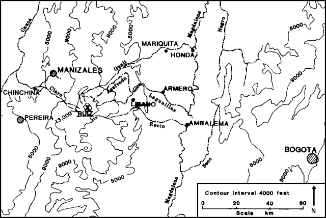 |
Figure 1. Map showing Ruiz volcano and its major drainages. Contour interval is 4,000 feet (about 1,200 m). |
Lahars traveled down 11 flank valleys, the most destructive inundating the city of Armero, where an estimated [21,000] of 25,000 residents died. The first mud, which reached Armero about [2335], was cold [reports that the mud became increasingly hot were incorrect]. Resident E. Nieto described "A frightening noise and then a blast of wind hit us and we saw fire falling from the sky." On the volcano's W flank, low-lying neighborhoods of Chinchiná were also buried by mud, and officials estimated that [1,000] died there. Geologists estimated that the lahars advanced at 30-35 km per hour; Armero, at about 300 m elevation, is 5 vertical kilometers below the summit of Ruiz.
No pyroclastic flows were observed during the eruption, but geologists noted deposits with cross-stratification typical of those from surges. The Refugio (about 2 km NW of the summit) was knocked down and its walls scattered radially downslope.
In hand specimen, the 13 November tephra appeared to be a dacitic andesite, about 30-40% phenocrysts, with plagioclase dominant, more hornblende than pyroxene, and a trace of biotite. No estimates of tephra thickness, volume, or extent were available at press time, but ashfall was reported as far away as Táchira, Venezuela, 500 km to the NE. Tephra fell on all but the S and SE flanks.
NASA's Nimbus-7 polar orbiting satellite passed over Ruiz on 14 November at 1151. Using data from its TOMS instrument, Arlin Krueger calculated that a cloud containing more than 0.5 x 10⁶ metric tons of SO2 covered a 650,000 km2 zone extending NE and slightly SW of the volcano (figure 2). Bernardo Londoño reported that the cloud extended to 10.5 km above the crater, but it remains uncertain whether the cloud reached the stratosphere. Heavy weather clouds prevented observation of the eruption on NOAA's weather satellite images. Lack of nearby wind data prevented precise altitude determination by correlation with cloud movement as indicated by Nimbus-7, but the available data suggested that it was upper tropospheric.
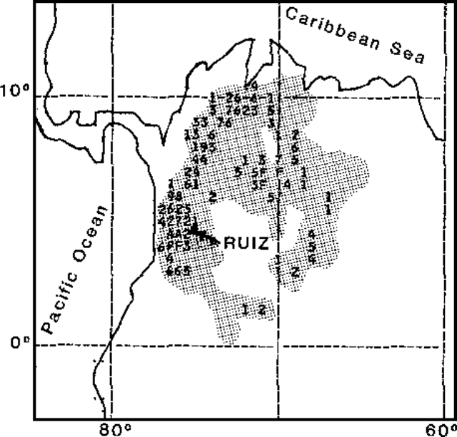 |
Figure 2. Preliminary SO2 data from the TOMS instrument of the Nimbus-7 satellite at 1151 on 14 November 1985. Each number or letter represents the average SO2 value within an area 50 km across. Values above 9 are represented by A, B, C, etc. The area of perturbed values is shaded. Courtesy of Arlin Krueger. |
As of 20 November, no additional strong explosions had occurred. Geologists who flew over the volcano reported that the crater had enlarged to about 300 m in diameter and 200 m deep, and that new fumaroles had developed 500-900 m from the crater, but they observed no lava flow. Newly installed telemetering seismometers recorded harmonic tremor of varying amplitude beginning 18 November at 0200 that preceded ash emission at 0600. An episode of stronger tremor that lasted from about 0600 to 0945 the next day was followed by a small explosion at 1030.
Geological Summary. Nevado del Ruiz is a broad, glacier-covered volcano in central Colombia that covers more than 200 km2. Three major edifices, composed of andesitic and dacitic lavas and andesitic pyroclastics, have been constructed since the beginning of the Pleistocene. The modern cone consists of a broad cluster of lava domes built within the caldera of an older edifice. The 1-km-wide, 240-m-deep Arenas crater occupies the summit. The prominent La Olleta pyroclastic cone located on the SW flank may also have been active in historical time. Steep headwalls of massive landslides cut the flanks. Melting of its summit icecap during historical eruptions, which date back to the 16th century, has resulted in devastating lahars, including one in 1985 that was South America's deadliest eruption.
Information Contacts: B. Salazar A., Central Hidroeléctrica de Caldas; B. Londoño, Comité de Estudios Vulcanológicos, Manizales; D. Herd and R. Tilling, USGS, Reston, VA; N. Banks, USGS CVO, Vancouver, WA; A. Krueger, NASA/GSFC; M. Matson and W. Gould, NOAA/NESDIS; J. Tomblin, UNDRO; J. Barquero and R. van der Laat, Univ. Nacional, Heredia, Costa Rica; AP.