Report on Piton de la Fournaise (France) — December 1985

Scientific Event Alert Network Bulletin, vol. 10, no. 12 (December 1985)
Managing Editor: Lindsay McClelland.
Piton de la Fournaise (France) Inflation, earthquake swarm, then summit crater fissure eruption
Please cite this report as:
Global Volcanism Program, 1985. Report on Piton de la Fournaise (France) (McClelland, L., ed.). Scientific Event Alert Network Bulletin, 10:12. Smithsonian Institution. https://doi.org/10.5479/si.GVP.SEAN198512-233020
Piton de la Fournaise
France
21.244°S, 55.708°E; summit elev. 2632 m
All times are local (unless otherwise noted)
"After the very short (28-hour) eruption on 2 December, seismic activity was limited to very small shallow events in the summit zone for a few days.
"Since 25 December some deeper events have occurred under the summit zone (1-3 km depth). On the 28th two strong events (20 s) were recorded on the whole seismic network (11 stations) followed by a few events on the 29th. During the evening of the 28th very small events were noticed at the summit station, followed by a very short crisis (1836-50) and opening of fractures inside Dolomieu crater (1854-57). Aphyric basalt began to cover a large part of the crater floor (figure 15).
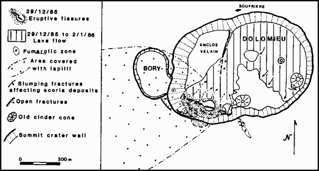 |
Figure 15. Map of the summit craters of Piton de la Fournaise as of 2 January 1986. Active fissures and lava flows produced since the beginning of the eruptive episode on 28 December 1985 are shown. Courtesy of OVPDLF. |
"The opening of the fractures was sudden and rocks, cinder, and lava were ejected to heights of as much as 250 m. Lava fountains were 100-150 m high for one day, than activity was limited to one main cone (1 January). On 9 January, the main cone was still active, emitting important volumes of gases, mainly SO2. Lava temperatures were between 1,140° and 1,150°C. Some pahoehoe was observed in tubes.
"After the 2 December eruption, deformation indicated no relaxation of the summit area. From 6-27 December, a progressive deformation was recorded (30 µrad) on the Bory permanent tiltmeter. Tilt stations around the summit indicated a small summit inflation. The summit area and the S and W flanks of Bory were affected by deformation. Nothing has been detected anywhere else in the Enclos."
Geological Summary. Piton de la Fournaise is a massive basaltic shield volcano on the French island of Réunion in the western Indian Ocean. Much of its more than 530,000-year history overlapped with eruptions of the deeply dissected Piton des Neiges shield volcano to the NW. Three scarps formed at about 250,000, 65,000, and less than 5,000 years ago by progressive eastward slumping, leaving caldera-sized embayments open to the E and SE. Numerous pyroclastic cones are present on the floor of the scarps and their outer flanks. Most recorded eruptions have originated from the summit and flanks of Dolomieu, a 400-m-high lava shield that has grown within the youngest scarp, which is about 9 km wide and about 13 km from the western wall to the ocean on the E side. More than 150 eruptions, most of which have produced fluid basaltic lava flows, have occurred since the 17th century. Only six eruptions, in 1708, 1774, 1776, 1800, 1977, and 1986, have originated from fissures outside the scarps.
Information Contacts: H. Delorme and J. Delarue, OVPDLF; P. Bachelery, Univ. de la Réunion.