Report on Nevado del Ruiz (Colombia) — December 1985

Scientific Event Alert Network Bulletin, vol. 10, no. 12 (December 1985)
Managing Editor: Lindsay McClelland.
Nevado del Ruiz (Colombia) Small ash eruption; 15,000 evacuated; no new mudflows
Please cite this report as:
Global Volcanism Program, 1985. Report on Nevado del Ruiz (Colombia) (McClelland, L., ed.). Scientific Event Alert Network Bulletin, 10:12. Smithsonian Institution. https://doi.org/10.5479/si.GVP.SEAN198512-351020
Nevado del Ruiz
Colombia
4.892°N, 75.324°W; summit elev. 5279 m
All times are local (unless otherwise noted)
Explosive activity on 4 January ejected a small amount of ash and was accompanied by vigorous seismicity. The 4 January activity did not generate mudflows or cause any apparent changes in river flow, but residents of low-lying areas were temporarily evacuated as a precautionary measure.
A series of earthquake swarms followed the 13 November eruption, including a strong swarm 12-13 December that was accompanied by deformation (figure 5). Seismicity then declined briefly, followed by a period of stronger seismicity 22-24 December, then diminished again at the end of December to about 10 events per day (M >= 0) and brief bursts of tremor. Epicenters were generally S of the active crater, extending E and W under the flanks. Before the 4 January eruption, focal depths decreased from 4-8 km to 2-5 km (below a datum at 3.8 km above sea level). EDM lines on the SW, N, NE, and E flanks began to show changes in the rate and/or direction of deformation between 19 and 24 December. Equipment problems prevented remeasurement of EDM lines immediately before the 4 January eruption, so the amount of pre-eruption inflation is uncertain. The net change in the lengths of several radial lines (of 5 km average length) measured 3 days after the eruption was about 10 cm, but this figure probably included substantial post-eruption deflation. By 28-30 December, small but distinct changes in rate or direction of tilt had begun to appear on all four electronic tilt stations (at 4,100 m elevation on the NE flank, 4,800 m on the W flank, about 3,900 m on the NW flank, and 4,600 m on the SE flank).
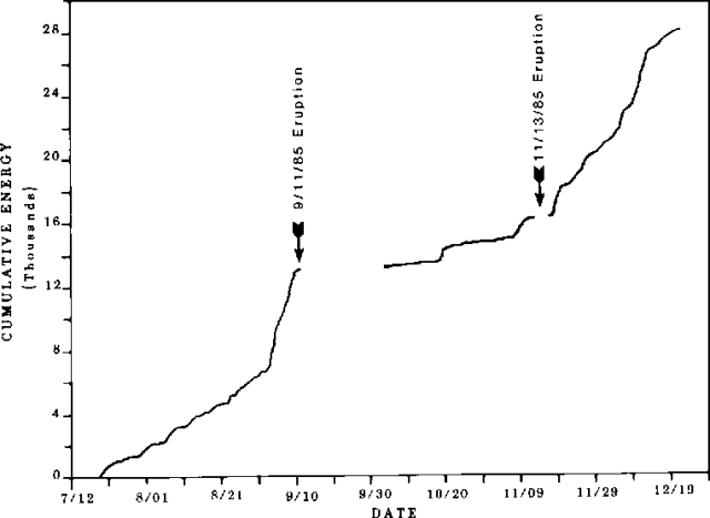 |
Figure 5. Seismic energy release at Ruiz volcano, 20 July-19 December 1985. Timing of eruptions on 11 September and 13 November are shown. Courtesy of the Comité de Estudios Vulcanológicos. |
Movement of cracks in summit glaciers continued through December and early January at roughly constant rates. Extensional changes of 5-10 cm per day were measured near the head of the Azufrado valley, and both extensional and compressional motion of a few mm to 5 cm per day elsewhere. Little baseline data exist on typical rates of glacier advance on Ruiz.
Strong seismicity began 3 January at about 2320, and was saturating seismographs within less than an hour. The seismicity was initially characterized by superimposed high- and low-frequency tremor, but tremor amplitude declined somewhat around 0115 and low-frequency (2-2.5 Hz) tremor began to dominate the seismic records at 0128. B-type earthquakes and explosion events accompanied the tremor. Darkness initially prevented direct observations of the summit, but ash began falling about 0300. The eruption cloud was small, generally 300-600 m high, occasionally rising to 1 km above the summit. Ashfalls were minor, concentrated around the summit and in a narrow zone to the WNW. Several hundred meters from the vent, new ash was only about 7 mm thick; 3 km downwind the deposit was only 2 mm deep; and only traces of ash were found more than 10 km away. Vigorous seismicity continued until about noon, then declined slowly until the eruption ended in mid-afternoon.
Evacuations of about 15,000 people from low-lying areas of the valleys of the Azufrado, Lagunillas, Recio, Gualí, Sabandija, and Chinchiná rivers began 4 January at about 0600. Most residents returned to their homes shortly after the eruption, but about 2,000 people remained evacuated 10 days later.
Smaller earthquake swarms occurred 5-7 January, then seismicity declined to about 1-2 A- or B-type events per hour, generally with magnitudes of 0 or less. No additional explosions or major increases in seismicity had occurred as of mid-January.
Further References. Herd, D.G., and Comité de Estudios Vulcanológicos, 1986, The 1985 Ruiz volcano disaster: EOS, v. 67, p. 457-460.
Katsui, Y., Takahashi, H., Egashira, S., Kawachi, S., and Watanabe, H., 1986, The 1985 eruption of Nevado del Ruiz volcano and associated mudflow disaster: Rep. Natur. Disast. Sci. Res., B-60-7, p. 1-102.
Naranjo, J.L., Sigurdsson, H., Carey, S., and Fritz, W.J., 1986, The November 13, 1985 eruption of Nevado del Ruiz volcano, Colombia: Tephra Fall and Lahars; Science, v. 233, p. 961-963.
Thouret, J.C., 1986, L'éruption du 13 Novembre 1985 au Nevado El Ruiz: L'originalité du dynamisme eruptif phréato-magmatique et plinien sur une calotte glaciaire aux latitudes equatoriales: Revue de Géographie Alpine, v. 74, no. 4, p. 373-391.
Valdiri Wagner, J. (ed.), 1987, Memorias del Simposio Internacional Sobre Neotectónica y Riesgos Volcánicos (Bogotá, Colombia, 1-3 Diciembre, 1986): Revista del Centro Interamericano de Fotointerpretación, v. 11, nos. 1-3, p. 1-399 (23 papers).
Williams, S.N., Stoiber, R.E., García, P.N., and others, 1986, Eruption of the Nevado del Ruiz volcano, Colombia, on November 13, 1985: gas flux and fluid geochemistry: Science, v. 233, p. 964-967.
Geological Summary. Nevado del Ruiz is a broad, glacier-covered volcano in central Colombia that covers more than 200 km2. Three major edifices, composed of andesitic and dacitic lavas and andesitic pyroclastics, have been constructed since the beginning of the Pleistocene. The modern cone consists of a broad cluster of lava domes built within the caldera of an older edifice. The 1-km-wide, 240-m-deep Arenas crater occupies the summit. The prominent La Olleta pyroclastic cone located on the SW flank may also have been active in historical time. Steep headwalls of massive landslides cut the flanks. Melting of its summit icecap during historical eruptions, which date back to the 16th century, has resulted in devastating lahars, including one in 1985 that was South America's deadliest eruption.
Information Contacts: P. Medina, Comité de Estudios Vulcanológicos, Manizales; N. Banks, USGS CVO, Vancouver, WA; AP.