Report on Kilauea (United States) — January 1986

Scientific Event Alert Network Bulletin, vol. 11, no. 1 (January 1986)
Managing Editor: Lindsay McClelland.
Kilauea (United States) Episodes 40 and 41 of East Rift Zone eruption
Please cite this report as:
Global Volcanism Program, 1986. Report on Kilauea (United States) (McClelland, L., ed.). Scientific Event Alert Network Bulletin, 11:1. Smithsonian Institution. https://doi.org/10.5479/si.GVP.SEAN198601-332010
Kilauea
United States
19.421°N, 155.287°W; summit elev. 1222 m
All times are local (unless otherwise noted)
EPISODE 40
Episode 40 began 1 January at 1309 and lasted 13.5 hours. It produced a lava flow ~9 km long that overlies earlier flows and reached the NE corner of Royal Gardens Subdivision (figure 41). The volume of this flow was 11.6 x 10⁶ m3. [A volcanic plume from the east rift crater could be seen from the Space Shuttle on 15 January (figure 42).]
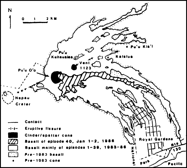 |
Figure 41. Lava flows produced by Kīlauea's East rift zone eruption since January 1983. Episode 40 flows are shown by a separate pattern. |
 |
Figure 42. Space Shuttle photograph (no. 61C-41-050), taken 15 January 1986, showing most of the island of Hawaii. Mauna Loa is at center. On its S flank is the much smaller Kīlauea, partially obscured by clouds. A large plume extends from the active east rift crater, Pu`u `O`o, following episode 40 of the eruption that began in January 1983. Courtesy of C. Wood. |
EPISODE 41
When episode 41 began on 27 January, after only 25 days of repose, only 9.5 µrad of the deflation that occurred during E-40 had been recovered (figure 43). Because of inclement weather, it was not possible to establish a precise start time from time-lapse film but the first lava spillover from the crater into the flow channel was reported by a helicopter pilot on 26 January at 1240. A field crew that was at Pu`u `O`o on 27 January from 1230 to 1600 observed almost continuous small spillovers. Deflation began on 27 January at 1900 and totaled 16.5 µrad by the end of E-41. Harmonic tremor started at 2030, increased at 2035 and continued at high amplitude until 0737 the next morning when lava production stopped. Lava flows extended 6.7 km to SE, to within 400 m of the NE corner of Royal Gardens Subdivision. By the end of January tilt had recovered 8.4 µrad.
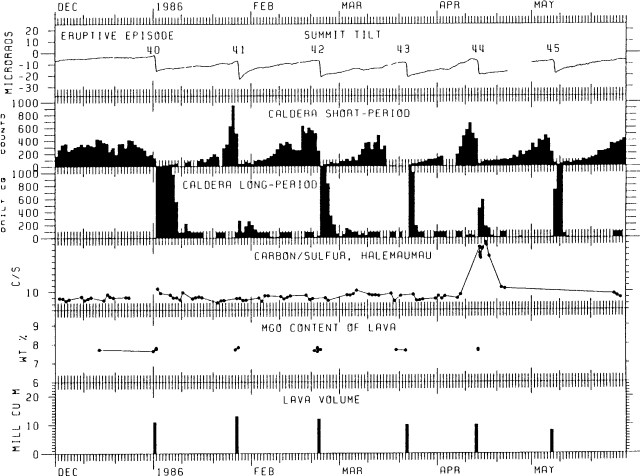 |
Figure 43. Six-month summary of Kīlauea's activity, January-June 1986, showing tilt, short- and long-period caldera earthquakes, carbon/sulfur ratio of summit gases, lava volumes, and the MgO content of lavas produced prior to and during major eruptive episodes. The main summit tiltmeter is still under repair, as indicated by the break in the tilt curve, but a substitute tiltmeter has been installed to record summit deformation. |
Geological Summary. Kilauea overlaps the E flank of the massive Mauna Loa shield volcano in the island of Hawaii. Eruptions are prominent in Polynesian legends; written documentation since 1820 records frequent summit and flank lava flow eruptions interspersed with periods of long-term lava lake activity at Halemaumau crater in the summit caldera until 1924. The 3 x 5 km caldera was formed in several stages about 1,500 years ago and during the 18th century; eruptions have also originated from the lengthy East and Southwest rift zones, which extend to the ocean in both directions. About 90% of the surface of the basaltic shield volcano is formed of lava flows less than about 1,100 years old; 70% of the surface is younger than 600 years. The long-term eruption from the East rift zone between 1983 and 2018 produced lava flows covering more than 100 km2, destroyed hundreds of houses, and added new coastline.
Information Contacts: C. Heliker, G. Ulrich, R. Koyanagi, and R. Hanatani, HVO.