Report on Piton de la Fournaise (France) — March 1986

Scientific Event Alert Network Bulletin, vol. 11, no. 3 (March 1986)
Managing Editor: Lindsay McClelland.
Piton de la Fournaise (France) First eruption outside caldera since 1977; evacuations; pit crater formed
Please cite this report as:
Global Volcanism Program, 1986. Report on Piton de la Fournaise (France) (McClelland, L., ed.). Scientific Event Alert Network Bulletin, 11:3. Smithsonian Institution. https://doi.org/10.5479/si.GVP.SEAN198603-233020
Piton de la Fournaise
France
21.244°S, 55.708°E; summit elev. 2632 m
All times are local (unless otherwise noted)
Eruptive activity resumed 19 March, after less than 6 weeks of quiet. This sixth episode of the eruption . . . included the first lava production outside the Enclos Caldera since 1977.
Pre-eruption seismicity and deformation. The first half of March was characterized by weak seismicity. On the l7th, intermediate-depth events began, centered 3 km below the summit. During the night and the next day, 7 events were recorded, all at the same depth, E of the summit zone. A seismic crisis began suddenly at 2246 and lasted 30 minutes without an eruption. All of the events were shallow and centered under the summit crater. A tiltmeter on the SW flank of Bory Crater and an extensiometer inside the crater recorded a sudden movement at 2245-2255 related to this intrusion. A 300-µrad inflation of the E portion of Dolomieu Crater was measured by the two tilt stations E of the summit area. Geodetic measurements between the Enclos Caldera and the summit showed a NW displacement of the E wall of Dolomieu. No movement was recorded within the caldera.
SE caldera eruption, 18-19 March. Significant seismic activity during the night of 18-19 March followed the intrusion and preceded fracturing that began in the S part of the caldera at 0500. An eruption began at 0640 in the SE part of the caldera (at the bottom of Nez Coupe du Tremblet; figure 17), producing lava fountains and a small flow from the 120°-trending fissure. The volume of lava erupted was low, and this phase ended at 1520. The seismic crisis, however, continued during the effusive activity with both deep (3-5 km) and summit events.
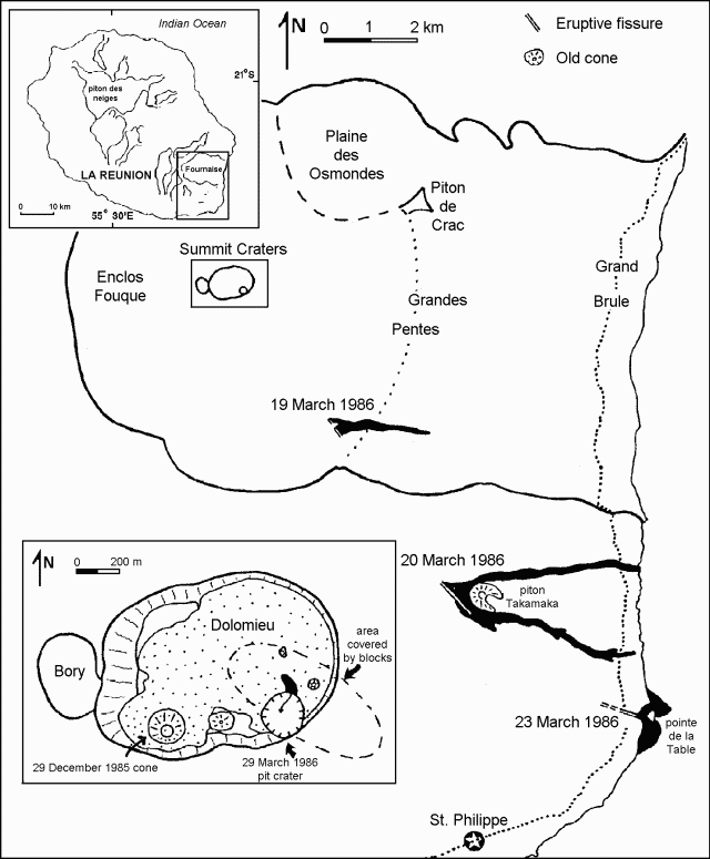 |
Figure 17. Map of Piton de la Fournaise showing the March 1986 eruption fissures, lava flows, and summit pit crater. Courtesy of P. Bachélery. |
Upper flank eruption, 20-22 March. On 20 March at 0020 a weak tremor was recorded in the S part (near the Nez Coupe du Tremblet station), and outside the caldera. Observation of glowing lava was possible only during pre-dawn hours because of poor weather conditions and dense vegetation. Tremor increased during the night, and another 120°-trending fissure, 600 m long, opened outside the caldera at 1,000 m altitude (just above Piton Takamaka; figure 17). At 0900, authorities evacuated 250 inhabitants. Two lava flows issued from the fissure, cutting the main circum-island road (RN 2) in the afternoon (at 1500 and 1700) of the 20th. One moved N of Piton Takamaka and reached the sea the next day. The second flow passed S of Piton Takamaka, stopping 200 m from the sea. Significant seismic activity continued in the summit area during the flank eruption. Lava destroyed 8 houses, leaving 51 people homeless. The lavas are olivine basalts with a small amount of 1-4 mm olivine phenocrysts. Effusive and seismic activity continued at a high level through 21-22 March.
Lower flank eruption, 23-29 March.Seismicity increased on the 23rd at 0000, with numerous shallow seismic events in the summit area. More than 30 magnitude 1.5-2.7 shocks were recorded during the night. At 0900 a fissure opened in the circum-island road S of the volcano at < 100 m altitude (near Pointe de la Table) initially emitting only water vapor. At about 1600, the fissure apparently began to extend downslope into thick forest. At 1700, very viscous lava emerged from three vents (in the forest) at an altitude of 30 m. A levelling network established around the fissures showed the progressive emplacement of a shallow dike. A new tilt station 1 km away from the fissures did not record any movement.
The opening of the main fissures across the road reached 105 cm on 23 March (70 cm during the first 5 hours). After the onset of lava production, the width of the main fissure decreased by 9 cm, but widening resumed, reaching 129 cm on the 27th and 167 cm on the 31st. Right-lateral movement accompanying the opening of the fissures was measured at 41.5 cm the first day and 49.7 cm by the 31st.
During the night of 23-24 March, more vigorous activity took place between Pointe de la Table and the circum-island road. Predominantly pahoehoe lava emerged from lava tubes and cascaded into the sea at two points near Pointe de la Table. On the 24th seismicity decreased and was limited to the summit zone. Effusive activity stopped on the upper flank fissure (near Piton Takamaka) that had begun to erupt on 20 March, but significant degassing continued. Activity from the lower flank fissures was strongest on 24 March at about 1400. Outflow rates on the 24th exceeded 7 m3/s and lava temperature was 1,160°C. By the time lava production stopped on 29 March at 0100, 3-4 x 10⁶ m3 of lava had built a very flat 30-hectare platform along the shore that contained many lava tubes. The lava front in the sea was ~1.5 km wide, and its maximum seaward extension was 150-200 m. The volume of degassed magma was ~5 x 10⁶ m3. This flow was less olivine-rich than the Takamaka lava.
Summit eruption and pit crater formation, 29 March-5 April. On 28 March at 1000 a new seismic crisis began, with tremor on the dome at 1110-1120. The seismic crisis was limited to the summit area and lava emission stopped outside the Enclos caldera. No deformation had affected the summit area during the 20-28 March period, but on the 29th at 1030-1600, the tiltmeter on the SW flank of Bory crater recorded progressive summit deflation of 23 µrads. Seismicity changed at midday to tremor-like activity. At 2238 a phreatic explosion began in Dolomieu crater and minor fountaining occurred from a fissure in its SE sector. By early the next morning collapse had formed a pit crater 100 m in diameter and 80-100 m deep. Degassed lava emerged from just below one edge, perhaps from a sill or still-molten 29 December lava [see 11:4], forming a 5-m-wide cascade that drained back into the bottom of the newly formed pit crater.
A general deflation of 35-350 µrads of the summit area, centered on the SE part of Dolomieu Crater, occurred on the 30th. This deflation was not detected by the Enclos tilt stations. The summit lava flow stopped around 5 April.
Magnetic data. Beginning in mid-l985, a permanent magnetic network has been maintained on the volcano. Four stations telemetered to the observatory: Bory Crater (BOR), the N flank of the dome (PMC), the W part of the Enclos Caldera (CSR), and the observatory (PDC), with a 1-minute sampling frequency of the earth's magnetic field. The time variations of the simultaneous differences are studied with CSR as the reference station. Several days before the first seismic crisis (17 March), a slow decrease in the differences appeared, ~2 nanoteslas (nT)/10 days. Early in the seismic crisis of 17 March, a sharp decrease in the differences was observed (~3.5 nT and 2 nT for CSR and BOR). Similar variations were observed on the 29th when the seismic crisis preceded pit crater formation. By 3 April, after the eruptive episode, variations were no longer observed.
Further Reference. Delorme, H., Bachelery, P., Blum, P.A., Cheminée, J.-L., Delarue, J., Delmond, J., Hirn, A., Lepine, J., Vincent, P., and Zlotnicki, J., 1989, March 1986 eruptive episodes at Piton de la Fournaise volcano (Réunion Island): JVGR, V. 36, p. 199-208.
Geological Summary. Piton de la Fournaise is a massive basaltic shield volcano on the French island of Réunion in the western Indian Ocean. Much of its more than 530,000-year history overlapped with eruptions of the deeply dissected Piton des Neiges shield volcano to the NW. Three scarps formed at about 250,000, 65,000, and less than 5,000 years ago by progressive eastward slumping, leaving caldera-sized embayments open to the E and SE. Numerous pyroclastic cones are present on the floor of the scarps and their outer flanks. Most recorded eruptions have originated from the summit and flanks of Dolomieu, a 400-m-high lava shield that has grown within the youngest scarp, which is about 9 km wide and about 13 km from the western wall to the ocean on the E side. More than 150 eruptions, most of which have produced fluid basaltic lava flows, have occurred since the 17th century. Only six eruptions, in 1708, 1774, 1776, 1800, 1977, and 1986, have originated from fissures outside the scarps.
Information Contacts: H. DeLorme, J-F. DeLarue, J. Delmond, J. Hoarau, A. Hirn, J. Lepine, J. Zlotnicki, C. Robin (IGN); Hakenholtz (EDF); Maison (TAAF), and DuPont (ONF), OVPDLF, Réunion Island; P. Bachelery, Univ de la Réunion; P. Vincent and A. Bonneville, Univ de Clermont; J-L. Le Mouel, J-L. Cheminée, P. Blum, and G. Brandeis, IPGP; M. Krafft, Cernay, France.