Report on Kilauea (United States) — July 1986

Scientific Event Alert Network Bulletin, vol. 11, no. 7 (July 1986)
Managing Editor: Lindsay McClelland.
Kilauea (United States) Episode 48 from three new fissures
Please cite this report as:
Global Volcanism Program, 1986. Report on Kilauea (United States) (McClelland, L., ed.). Scientific Event Alert Network Bulletin, 11:7. Smithsonian Institution. https://doi.org/10.5479/si.GVP.SEAN198607-332010
Kilauea
United States
19.421°N, 155.287°W; summit elev. 1222 m
All times are local (unless otherwise noted)
Episode 48 (E-48). "After 22 days of repose, E-48 . . . began on 18 July with a local earthquake swarm and eruptions from new fissures on both the uprift and downrift sides of the Pu`u `O`o cone. At the time of the swarm, the magma column had reached the top of the conduit and was emitting spatter from a 15-m-high cone within Pu`u `O`o, but as fissures opened, the column subsided, the top of the spatter cone collapsed, and only burning gas issued from the small opening for the duration of the activity. After nearly 23 hours, activity ended temporarily on 19 July at around 0930. Mostly pahoehoe flows were produced. The longest flow moved rapidly SE for 7.5 km through a forested part of the Hawaii Volcanoes National Park to within 2.5 km of the sea. The Chain of Craters road was closed briefly until the flow stagnated, and ~4 km2 of forest were burned.
"On 20 July at about 0830, following 23 hours of inactivity, low fountains on the downrift fissure ("B" on figure 44) were first observed by a National Park Service overflight while the "A" fissure and the main Pu`u `O`o conduit remained quiet. By 0950, the "B" fissure had shut down and a new fissure ("C" on figure 44) had begun to erupt along a line parallel to, and ~150 m N of, the original January 1983 fissure. Low fountains, a few meters high, played intermittently along the 1100-m-long fissure, which eventually shortened to a pair of vents, < 50 m apart, that have continuously produced lava at a low rate. A pahoehoe shield, ~1.2 km2 in area and > 25 m high, has been built around the vents and a branching tube-fed pahoehoe and aa flow has moved ~4.5 km SE toward the sea. By the end of July, it had stagnated and remained ~6 km upslope from the nearest developed area. As of 8 August, lava was still welling out of one main vent without fountaining and was spreading over the summit of the growing shield. The new basalt flows have sparse small (<1 mm) olivine phenocrysts, similar to those of recent eruptions.
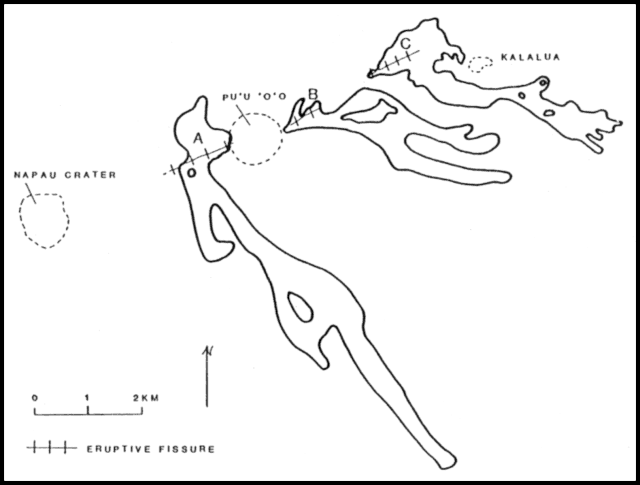 |
Figure 44. Sketch map of eruptive fissures A-C and lava flows on Kīlauea's East rift zone, July 1986. Courtesy of HVO. |
"The earthquake swarm . . . began on 18 July at 1046 and progressed downrift. It was recorded by seismometers just uprift of Pu`u `O`o and N of Kalalua. High tremor amplitudes on the uprift seismometer characterized the early phase of activity. From 20 July on, the tremor on the uprift instrument decreased to background levels, while very low-amplitude tremor has continued on the downrift instrument nearest the eruption vent. Above-normal levels of long-period seismicity occurred following the early activity of E-48 (figure 45).
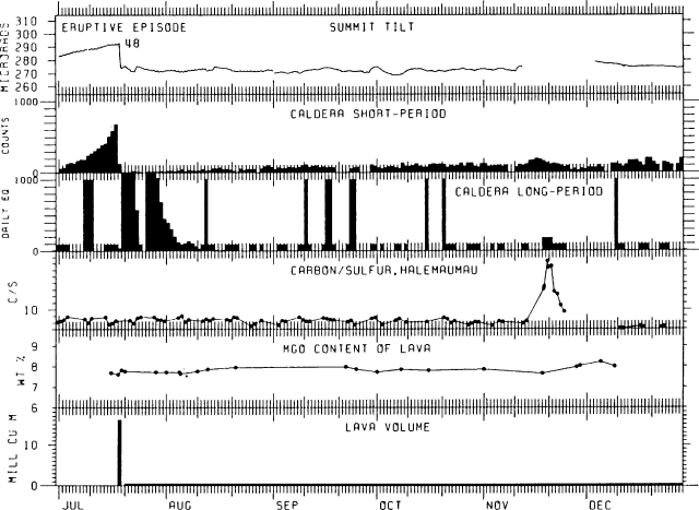 |
Figure 45. Six-month summary of Kīlauea's activity, July-December 1986, showing tilt, short- and long-period earthquakes, carbon/sulfur ratio of summit gases, lava volume, and the MgO content of lava. The intermediate depth swarm of 17-20 November are "C" type long-period (deeper) earthquakes and the caldera long-period earthquakes are "A" type (shallow) events, so the swarm is not shown on this summary. |
"Deflationary summit tilt began on 18 July at about 1145, an hour after the onset of seismicity, and reached a record rate of nearly 3.1 µrad/hour between 1200 and 1300 (figure 45). The deflationary pattern reversed temporarily into an inflationary trend from about 0500 on 19 July, in concert with the short repose period. Since 20 July, tilt changes have been very small and no particular trend has been defined."
Geological Summary. Kilauea overlaps the E flank of the massive Mauna Loa shield volcano in the island of Hawaii. Eruptions are prominent in Polynesian legends; written documentation since 1820 records frequent summit and flank lava flow eruptions interspersed with periods of long-term lava lake activity at Halemaumau crater in the summit caldera until 1924. The 3 x 5 km caldera was formed in several stages about 1,500 years ago and during the 18th century; eruptions have also originated from the lengthy East and Southwest rift zones, which extend to the ocean in both directions. About 90% of the surface of the basaltic shield volcano is formed of lava flows less than about 1,100 years old; 70% of the surface is younger than 600 years. The long-term eruption from the East rift zone between 1983 and 2018 produced lava flows covering more than 100 km2, destroyed hundreds of houses, and added new coastline.
Information Contacts: G. Ulrich, HVO.