Report on Okmok (United States) — December 1986
Scientific Event Alert Network Bulletin, vol. 11, no. 12 (December 1986)
Managing Editor: Lindsay McClelland.
Okmok (United States) Tephra eruption and debris flow
Please cite this report as:
Global Volcanism Program, 1986. Report on Okmok (United States) (McClelland, L., ed.). Scientific Event Alert Network Bulletin, 11:12. Smithsonian Institution. https://doi.org/10.5479/si.GVP.SEAN198612-311290
Okmok
United States
53.43°N, 168.13°W; summit elev. 1073 m
All times are local (unless otherwise noted)
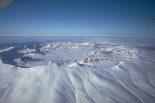
A steam and ash plume was rising to ~200 m above a cinder cone in the SW part of the caldera when Aleutian Air pilot T. Madsen flew past the volcano on 18 November at 1320. Winds blew ash to the SE. Because of his low flight altitude, Madsen was unable to determine the extent of recent ash deposits. The active cone, probably Cone A of Byers (1959) is one of eight that ring the inside of the 9-km Okmok caldera.
No additional reports of activity were received until 5 January [but see 12:1], when a small ash eruption was observed by Peninsula Airways pilot H. Wilson, ~13 hours after a large earthquake with an epicenter 130 km to the SW. The shallow, Ms 6.6 event occurred at 0312, centered at 52.47°N, 169.28°W. Objects were knocked off shelves in Nikolski, 65 km to the SW, but there was no structural damage. When Wilson flew over Okmok at 1630, a 300-m-high steam and ash plume was being emitted, again from Cone A in the SW part of the caldera. A small debris flow had descended to the cone's SE foot. Fresh black ash extended NE from the cone across the caldera floor and over the caldera rim, 9 km away, where Wilson estimated that the ash deposit was ~5 km wide. The deposit thinned noticeably with distance from the cone, and was difficult to recognize beyond the caldera rim because the volcano's flanks were snow-free. Although there were snow squalls in the area, the ash lacked any obvious snow cover.
Reference. Byers, F. M., Jr., 1959, Geology of Umnak and Bogoslof Islands, Aleutian Islands, Alaska: USGS Bulletin 1028-L, p. 267-369.
Geological Summary. The broad, basaltic Okmok shield volcano, which forms the NE end of Umnak Island, has a dramatically different profile than most other Aleutian volcanoes. The summit of the low, 35-km-wide volcano is cut by two overlapping 10-km-wide calderas formed during eruptions about 12,000 and 2050 years ago that produced dacitic pyroclastic flows that reached the coast. More than 60 tephra layers from Okmok have been found overlying the 12,000-year-old caldera-forming tephra layer. Numerous satellitic cones and lava domes dot the flanks of the volcano down to the coast, including 1253-m Mount Tulik on the SE flank, which is almost 200 m higher than the caldera rim. Some of the post-caldera cones show evidence of wave-cut lake terraces; the more recent cones, some of which have been active historically, were formed after the caldera lake, once 150 m deep, disappeared. Hot springs and fumaroles are found within the caldera. Historical eruptions have occurred since 1805 from cinder cones within the caldera.
Information Contacts: J. Reeder, Alaska Division of Geological and Geophysical Surveys (ADGGS).