Report on Nevado del Ruiz (Colombia) — May 1987
Scientific Event Alert Network Bulletin, vol. 12, no. 5 (May 1987)
Managing Editor: Lindsay McClelland.
Nevado del Ruiz (Colombia) Ash emission; fine ash to 50 km W
Please cite this report as:
Global Volcanism Program, 1987. Report on Nevado del Ruiz (Colombia) (McClelland, L., ed.). Scientific Event Alert Network Bulletin, 12:5. Smithsonian Institution. https://doi.org/10.5479/si.GVP.SEAN198705-351020
Nevado del Ruiz
Colombia
4.892°N, 75.324°W; summit elev. 5279 m
All times are local (unless otherwise noted)
Activity increased again after several months at low to moderate levels. Swarms of high-frequency earthquakes occurred 21 and 22 May, 3-6 km SW of the active crater (Arenas), at an average depth of ~6 km. 125 events were registered above the count threshold, with a maximum magnitude of 2.0. Low-frequency events (B-type) remained stable. Slightly shallower seismic events were recorded following the swarm, similar to observations after the previous swarm (16 April).
Harmonic tremor was generally absent or just above background, but increased suddenly on 9 June at 2007 to levels close to saturation, similar to the tremor activity recorded for months after the 4 May 1986 ash emission. Ashfall was first reported more than an hour later at 2115 (at Cerro Gualí) but visibility was poor, so the onsets of ash emission from Arenas Crater and tremor may have been simultaneous. Fine ash fell 40-50 km to the W, and by the afternoon of 10 June, 3.5 cm had accumulated 6 km W of the volcano. Initial microscopic inspection indicated no fresh glass in the ash. A helicopter overflight 11 hours after activity began revealed no impact craters or other evidence of ejection of large tephra. Minor melting of summit-area ice caused small increases in the flows of W flank rivers, but no evacuations were necessary. No pyroclastic flows were observed. After the first day of activity, ash emission declined irregularly, and had ended four days later. Tremor declined steadily, with no apparent correlation between its amplitude and observed fluctuations in ash emission.
COSPEC data showed that SO2 emission rates increased slightly for a few days after the May earthquake swarm, to a maximum of 2,300 t/d. Weather clouds and ash hampered COSPEC measurements during the ash emission period. Values ranged from 850 t/d on the first day of the activity to 3,600 t/d the second and fifth days, but because of masking effects of the ash, these are minimum values.
Deformation measurements did not yield values that correlated clearly between stations or with seismic and eruptive activity. One dry-tilt station N of the summit showed a change of 12 µrad just before the May seismic swarm, and a SE-flank electronic tilt station recorded ~11 µrad of inflation in the week before the swarm.
The deaths of birds mentioned in 12:03 [and originally in 12:04] were observed 2-4 April, 25-26 km NE of Arenas Crater (in Casabianca, Villahermosa, and Herveo) and at 4,200 m altitude 8 km S of the crater (at Laguna Verde). An estimated 2,000 birds died in that 3-day period, during which clouds and rain were almost continuous, and residents reported a constant rotten egg odor. Most of the affected birds, generally migrants en route to North America, fell to the ground between the hours of 0300 and 0400. Some were still alive but had evident breathing problems, and some survived several days before dying. Seventeen birds were taken to the Instituto Colombiano de Agricultura for study. All had lung damage, and autopsies suggested that they died from carbon monoxide poisoning. There were no reports of ill effects to humans. Similar bird mortalities were reported at the end of the 19th century during a period of increased fumarolic activity at Ruiz.
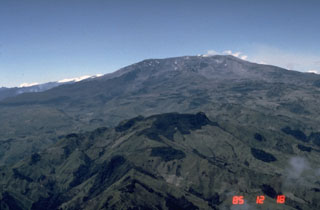
Geological Summary. Nevado del Ruiz is a broad, glacier-covered volcano in central Colombia that covers more than 200 km2. Three major edifices, composed of andesitic and dacitic lavas and andesitic pyroclastics, have been constructed since the beginning of the Pleistocene. The modern cone consists of a broad cluster of lava domes built within the caldera of an older edifice. The 1-km-wide, 240-m-deep Arenas crater occupies the summit. The prominent La Olleta pyroclastic cone located on the SW flank may also have been active in historical time. Steep headwalls of massive landslides cut the flanks. Melting of its summit icecap during historical eruptions, which date back to the 16th century, has resulted in devastating lahars, including one in 1985 that was South America's deadliest eruption.
Information Contacts: H. Meyer, INGEOMINAS, Manizales.

