Report on Piton de la Fournaise (France) — August 1987

Scientific Event Alert Network Bulletin, vol. 12, no. 8 (August 1987)
Managing Editor: Lindsay McClelland.
Piton de la Fournaise (France) Lava flows from summit crater
Please cite this report as:
Global Volcanism Program, 1987. Report on Piton de la Fournaise (France) (McClelland, L., ed.). Scientific Event Alert Network Bulletin, 12:8. Smithsonian Institution. https://doi.org/10.5479/si.GVP.SEAN198708-233020
Piton de la Fournaise
France
21.244°S, 55.708°E; summit elev. 2632 m
All times are local (unless otherwise noted)
Seismicity beneath the summit continued after the 2 June intrusion. Minor inflation was recorded through 6 June. The volcano then remained stable until a new intrusion developed below the E summit zone at 0411 on 9 June. Seismicity ceased at 0500 but no eruption occurred. Hypocenters were concentrated along a N-S axis, 1-1.5 km under Dolomieu.
On 10 June, 50 µrads of inflation in the upper summit zone were recorded. At 1510 that day an eruption began in the S part of the crater along a 50-m N-S fissure. Lava broke out the next day in the E part of the crater (figure 18). About 106 m3 of aphyric basalt were extruded by 28 June. During this phase, two inflation pulses were recorded by the permanent tiltmeter network, on 18 and 22-26 June. After 28 June, moderate seismicity and slight deformation were recorded. Significant inflation was observed on 19 July from 0450 to 0630 during a new intrusion crisis, mainly in the NE part of Dolomieu. Seismicity shifted from N to S at about 0535. An eruption then occurred at two sites. The main eruption was 1 km S of the summit craters, close to Chateau-Fort (1948 eruption site), lasted ~32 hours, and produced slightly more than 106 m3 of aphyric basalt. Poor weather conditions prevented clear observation of the less-active site 1.5 km NNE of the summit. Deformation changes have not been significant since the eruptions, but weak summit-area seismicity began 15 August and was continuing in the first week of September.
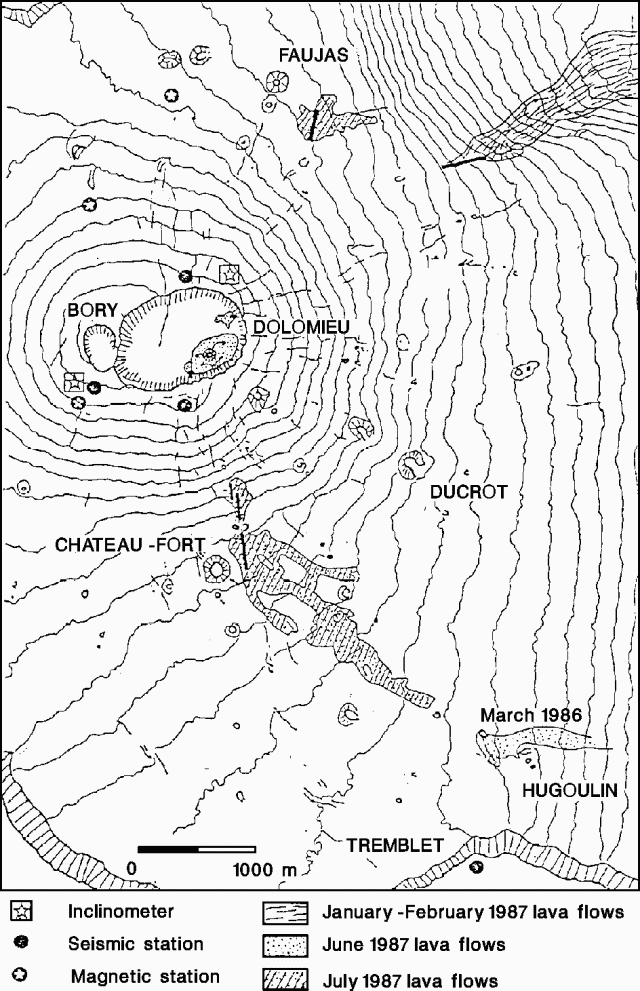 |
Figure 18. Map of the summit area of Piton de la Fournaise showing 1987 lava flows. Courtesy of P. Bachélery. |
Geological Summary. Piton de la Fournaise is a massive basaltic shield volcano on the French island of Réunion in the western Indian Ocean. Much of its more than 530,000-year history overlapped with eruptions of the deeply dissected Piton des Neiges shield volcano to the NW. Three scarps formed at about 250,000, 65,000, and less than 5,000 years ago by progressive eastward slumping, leaving caldera-sized embayments open to the E and SE. Numerous pyroclastic cones are present on the floor of the scarps and their outer flanks. Most recorded eruptions have originated from the summit and flanks of Dolomieu, a 400-m-high lava shield that has grown within the youngest scarp, which is about 9 km wide and about 13 km from the western wall to the ocean on the E side. More than 150 eruptions, most of which have produced fluid basaltic lava flows, have occurred since the 17th century. Only six eruptions, in 1708, 1774, 1776, 1800, 1977, and 1986, have originated from fissures outside the scarps.
Information Contacts: H. Delorme and B. Gillet, OVPDLF; P. Bachelery, Univ de la Réunion; J-L. Cheminee, A. Hirn, J. LePine, P. Blum, and J. Zlotnicki, IPGP.