Report on Tupungatito (Chile-Argentina) — December 1987
Scientific Event Alert Network Bulletin, vol. 12, no. 12 (December 1987)
Managing Editor: Lindsay McClelland.
Tupungatito (Chile-Argentina) Increased summit thermal activity, small ash eruption in January 1986; 50-km-long lahar kills 41 people
Please cite this report as:
Global Volcanism Program, 1987. Report on Tupungatito (Chile-Argentina) (McClelland, L., ed.). Scientific Event Alert Network Bulletin, 12:12. Smithsonian Institution. https://doi.org/10.5479/si.GVP.SEAN198712-357010
Tupungatito
Chile-Argentina
33.425°S, 69.797°W; summit elev. 5660 m
All times are local (unless otherwise noted)
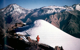
"Reactivation of one of the NW craters with a weak emission of black ash occurred 20 January 1986 at 1030 (figure 1). The activity was observed by the pilot of a Chilean Air Force C-130 and reported directly by radio-telephone to the author. The volcano had been under observation since the last pyroclastic eruption occurred 10 January 1980. After the M 7.8 earthquake that affected the Santiago region on 3 March 1985, vertical aerial photographic coverage was carried out at a scale of 1:20,000 on 25 March 1985. No increased activity was observed within the caldera, which has a diameter of ~5 km and is covered with ice and snow. Glaciers descend from it toward the W. The group of cones and craters with historic activity, in the extreme NW of the caldera, have only a thin covering of snow. Observations on 24 November 1987 show ice partially covered by 20 January 1986 ash, and intense solfataric activity in the same crater (figure 1).
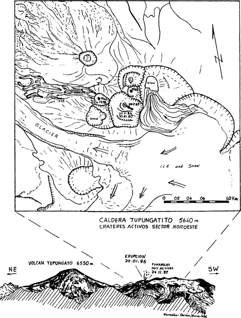 |
Figure 1. Sketch map by O. González-Ferrán of the summit area of Tupungatito, labeling craters active in recent eruptions and the location of vigorous solfataric activity on 24 November 1987. |
"On 4 December, new aerial photographic coverage of the Tupungatito volcanic region was taken by the Air Force Aerophotogrammetric Service at the request of the author and the National Emergency Office.
Analysis of the airphotos revealed a notable increase in snowmelt inside Tupungatito's active craters and an important increase in fumarolic activity without showing a direct relation with the 29 November lahar.
"The volcano remains under observation. If it produced an eruptive reactivation of some magnitude it could: affect the glacier covering the caldera; cause lahars larger than the one that occurred 29 November; and seriously damage the S sector of Santiago, Chile and Mendoza, Argentina."
Event in the Estero del Parraguirre. "On 29 November 1987, because of a regional (summer) thaw and the instability of mountains affected by the 1985 earthquake, an avalanche was generated in a small valley (Quebrada de Parraguirre) in the volcanic area. The avalanche caused a mudflow that descended the Río Colorado, killing 41 persons, destroying roads, machinery, and the Los Maitenes hydroelectric plant along some 50 km until its confluence with the Río Maipó, which passes through the city of Santiago. Also affected were the city's drinking water installations, and some 500,000 persons were left without water for 48 hours."
Geological Summary. Tupungatito volcano, the northernmost historically active volcano of the central Chilean Andes, is located along the Chile-Argentina border about 90 km E of Santiago and immediately SW of the Pleistocene Tupungato volcano. Tupungatito consists of a group of 12 Holocene andesitic and basaltic andesite craters and a pyroclastic cone at the NW end of the 4-km-wide, Pleistocene dacitic Nevado Sin Nombre caldera, which is filled by glaciers at its southern end and is breached to the NW. Lava flows from the northernmost vent have traveled down the NW flank breach. Tupungatito has produced frequent mild explosive eruptions during the 19th and 20th centuries.
Information Contacts: O. González-Ferrán, Univ de Chile.