Report on Krakatau (Indonesia) — March 1988
Scientific Event Alert Network Bulletin, vol. 13, no. 3 (March 1988)
Managing Editor: Lindsay McClelland.
Krakatau (Indonesia) Two lava flows from new crater; glowing blocks
Please cite this report as:
Global Volcanism Program, 1988. Report on Krakatau (Indonesia) (McClelland, L., ed.). Scientific Event Alert Network Bulletin, 13:3. Smithsonian Institution. https://doi.org/10.5479/si.GVP.SEAN198803-262000
Krakatau
Indonesia
6.1009°S, 105.4233°E; summit elev. 285 m
All times are local (unless otherwise noted)
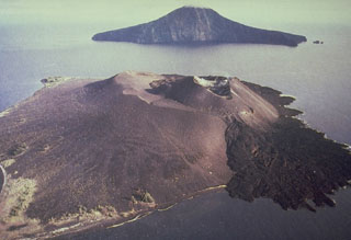
On 16 March, a group from VSI visited Anak Krakatau. The eruption . . . had created a new crater on the SSE flank of the 1960-81 Vulcanian cone. The new crater was ~80 m wide and 150-200 m in length, with the long axis oriented approximately NNW-SSE. Its low point was on the SSE side at an altitude of 140 m. Lava emerging from a vent at that point fed one small flow moving SSW, and a second, longer flow to the SE. The second flow had descended from the 1960-81 cone onto the old crater floor (between the pre-1960 crater rim and the younger inner cone).
A single vigorous fumarole, on the SSW slope of the 1960-81 cone ~50-80 m W of the new 1988 crater, was active about every 5 minutes . . . . Reports from the forestry observer on Sertung Island (4 km W) indicated that incandescent blocks were ejected from this vent. Some of the blocks were thrown into the sea outside the new crater, ~500 m from the vent. During the 16 March visit, this vent was only mildly active, so geologists were able to enter it and collect samples from the current activity. Hand-specimen petrography indicated that the 1988 lava resembles the 1980 plagioclase andesite (SiO2 53-54%) and is clearly not like the dacite bombs of the 1981 Vulcanian eruption (SiO2 62-63%).
Geological Summary. The renowned Krakatau (frequently mis-named as Krakatoa) volcano lies in the Sunda Strait between Java and Sumatra. Collapse of an older edifice, perhaps in 416 or 535 CE, formed a 7-km-wide caldera. Remnants of that volcano are preserved in Verlaten and Lang Islands; subsequently the Rakata, Danan, and Perbuwatan cones were formed, coalescing to create the pre-1883 Krakatau Island. Caldera collapse during the catastrophic 1883 eruption destroyed Danan and Perbuwatan, and left only a remnant of Rakata. This eruption caused more than 36,000 fatalities, most as a result of tsunamis that swept the adjacent coastlines of Sumatra and Java. Pyroclastic surges traveled 40 km across the Sunda Strait and reached the Sumatra coast. After a quiescence of less than a half century, the post-collapse cone of Anak Krakatau (Child of Krakatau) was constructed within the 1883 caldera at a point between the former Danan and Perbuwatan cones. Anak Krakatau has been the site of frequent eruptions since 1927.
Information Contacts: VSI.

