Report on Nevado del Ruiz (Colombia) — June 1988

Scientific Event Alert Network Bulletin, vol. 13, no. 6 (June 1988)
Managing Editor: Lindsay McClelland.
Nevado del Ruiz (Colombia) Daily ash emissions; continued strong seismicity
Please cite this report as:
Global Volcanism Program, 1988. Report on Nevado del Ruiz (Colombia) (McClelland, L., ed.). Scientific Event Alert Network Bulletin, 13:6. Smithsonian Institution. https://doi.org/10.5479/si.GVP.SEAN198806-351020
Nevado del Ruiz
Colombia
4.892°N, 75.324°W; summit elev. 5279 m
All times are local (unless otherwise noted)
Several small brief ash emissions occurred daily during June, all associated with increased harmonic tremor. Ash fell to the W, usually <10 km from the vent. High-frequency earthquakes increased to 2,362 in June, while low-frequency events decreased to 1,758. A significant high-frequency swarm (273 events) occurred on 15 June (figure 13). There were 212 shallow events in June and daily energy release tended to increase, continuing a trend that began in late 1987 (figure 14). Average SO2 content was 1,700 t/d (measured by COSPEC), a decrease from May's average of 2,435 t/d. Deformation measurements showed no significant changes.
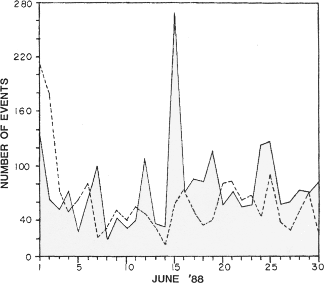 |
Figure 13. Daily number of recorded seismic events of high (solid line) and low frequency (dashed line), June 1988. Courtesy of the Observatorio Vulcanológico de Colombia. |
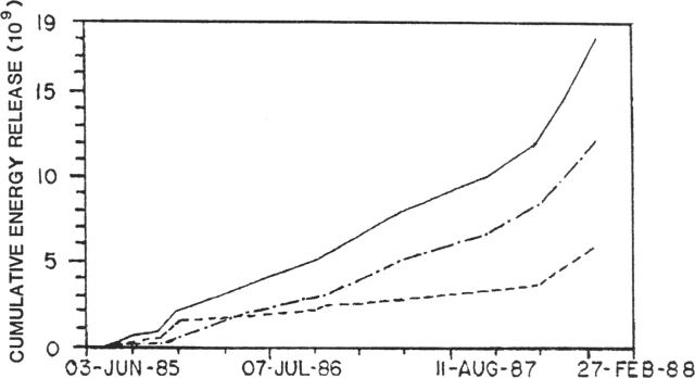 |
Figure 14. Cumulative seismic energy release at Ruiz, June 1985-February 1988. The solid line sums high- and low-frequency energy release, indicated by dashed and dotted lines, respectively. Courtesy of the Observatorio Vulcanológico de Colombia. |
Geological Summary. Nevado del Ruiz is a broad, glacier-covered volcano in central Colombia that covers more than 200 km2. Three major edifices, composed of andesitic and dacitic lavas and andesitic pyroclastics, have been constructed since the beginning of the Pleistocene. The modern cone consists of a broad cluster of lava domes built within the caldera of an older edifice. The 1-km-wide, 240-m-deep Arenas crater occupies the summit. The prominent La Olleta pyroclastic cone located on the SW flank may also have been active in historical time. Steep headwalls of massive landslides cut the flanks. Melting of its summit icecap during historical eruptions, which date back to the 16th century, has resulted in devastating lahars, including one in 1985 that was South America's deadliest eruption.
Information Contacts: E. Parra, R. Mendez, and F. Muñoz, INGEOMINAS, Manizales.