Report on Sabancaya (Peru) — June 1988

Scientific Event Alert Network Bulletin, vol. 13, no. 6 (June 1988)
Managing Editor: Lindsay McClelland.
Sabancaya (Peru) Increased fumarolic activity
Please cite this report as:
Global Volcanism Program, 1988. Report on Sabancaya (Peru) (McClelland, L., ed.). Scientific Event Alert Network Bulletin, 13:6. Smithsonian Institution. https://doi.org/10.5479/si.GVP.SEAN198806-354006
Sabancaya
Peru
15.787°S, 71.857°W; summit elev. 5960 m
All times are local (unless otherwise noted)
Sabancaya reportedly began strong fumarolic activity in December 1986 [see also 15:05]. Interviews with area residents indicated that glowing tephra ejections from the crater were visible at night. Seismicity was felt on the flanks but was not noticed at a distance of 15 km.
A summit photograph was taken 10 August 1987, 8 months after initial reports of activity, during a civil defense helicopter reconnaissance in response to requests from residents and local authorities. Light to dense steam emerged from several sources in a moat surrounding the central plug of the middle (of at least three) summit cone. The dome, moat, and surrounding pyroclastic cone were covered with thick ice and snow except in areas adjacent to steam emission.
Geologists observed the volcano 22-24 June 1988.
22 June (Banks, Hall, Salas, Mothes, and Huaman; at 40 km distance with binoculars.) Every 0.5-2 minutes, voluminous steam pulses, some with dark, basal "rooster-tails," rose 0.5-1 km above the summit. A yellowish plume streamed horizontally 10-15 km E. A dark area of several tens to hundreds of square meters was prominent on the NE slope adjacent to the source of the steam emission.
23 June (Hall, Salas, Mothes, and Huaman; at 15 km.) Activity was similar to 22 June with perhaps slightly decreased plume heights. Strong sulfurous fumes were reported by flank inhabitants. Some cattle had died in these areas, either directly from the fumes or after eating contaminated foliage.
24 June (Banks, Lazo, Portillo, Salas, Huaman, and Tejada; from a fixed-wing flight supported by the Fuerza Aérea del Perú in coordination with the Defensa Civil. Observations are preliminary and will be improved by analysis of photographs and geological investigations on the ground.) A continuous annular crack encircled the outer flanks of an old pyroclastic cone. Weak to moderate fumarolic activity emitted vapor along the annular crack and the dome's edges. Frequent steam emissions (every 1-2 minutes) rose 0.3-5 km and originated from a vent in the moat on the SE side of the dome. Emission energy was substantially less than on 22 June. Some ejection events were lightly colored with ash but no "rooster-tail" forms were noted. Initial white steam pulses dissipated 500 m above the crater, but a yellowish plume streamed more than 10 km E. There was ~ 20-50 x 106 m3 of ice and snow on Sabancaya, a substantial decrease since the August 1987 observations. A bare area, devoid of snow and ice, surrounded the annular crack at variable distances averaging 50 m. Snow beyond this bare area was lightly dusted with ash, particularly on the SE side nearest the pulsing steam vent. Fresh sulfur surrounded many of the fumaroles. Several tens of meters in the bare area, S of the summit, were yellow. No crater lake was observed in the moat between the central dome and the surrounding pyroclastic cone. No new lava or bomb craters were observed. Sabancaya appeared to be built on a pile of young, thick, blocky lava flows and domes erupted from a vent on the mid-NE flanks of the larger Ampato volcano (figure 1). No thick pyroclastic deposits were obvious on Sabancaya or Ampato.
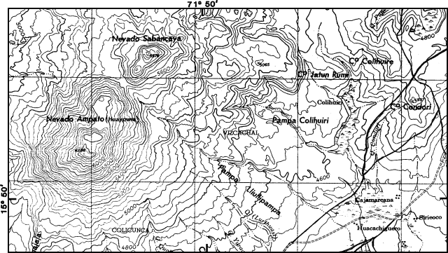 |
Figure 1. Map of Sabancaya and Ampato showing the plateau, drainage system, and villages to the SE. Contour interval, 50 m. From the Chivay sheet (1:100,000), Instituto Geográfico Militar, 1980. |
25 June (at 30 km from Aeroperú flight.) Activity was greatly diminished relative to that of 24 June.
Geological Summary. Sabancaya, located in the saddle NE of Ampato and SE of Hualca Hualca volcanoes, is the youngest of these volcanic centers and the only one to have erupted in historical time. The oldest of the three, Nevado Hualca Hualca, is of probable late-Pliocene to early Pleistocene age. The name Sabancaya (meaning "tongue of fire" in the Quechua language) first appeared in records in 1595 CE, suggesting activity prior to that date. Holocene activity has consisted of Plinian eruptions followed by emission of voluminous andesitic and dacitic lava flows, which form an extensive apron around the volcano on all sides but the south. Records of observed eruptions date back to 1750 CE.
Information Contacts: N. Banks, CVO; M. Hall, Instituto Geofísico, and P. Mothes, Defensa Civil liaison, Quito, Ecuador; M. Lazo, G. Salas Alvarez, and H. Portillo, Univ Nacional de Arequipa; D. Huaman, Instituto Geofísico del Perú, Lima; M. Tejada, Tercera Region Defensa Civil, Arequipa.