Report on Nevado del Ruiz (Colombia) — September 1988

Scientific Event Alert Network Bulletin, vol. 13, no. 9 (September 1988)
Managing Editor: Lindsay McClelland.
Nevado del Ruiz (Colombia) Small ash emissions; continued strong seismicity
Please cite this report as:
Global Volcanism Program, 1988. Report on Nevado del Ruiz (Colombia) (McClelland, L., ed.). Scientific Event Alert Network Bulletin, 13:9. Smithsonian Institution. https://doi.org/10.5479/si.GVP.SEAN198809-351020
Nevado del Ruiz
Colombia
4.892°N, 75.324°W; summit elev. 5279 m
All times are local (unless otherwise noted)
The number of high- and low-frequency seismic events increased in September. Although seismic energy release declined slightly from August, energy release has risen substantially during 1988 (figure 18). Most September seismicity was centered ~4 km SE of the crater at depths of 0.5-7 km. A high-frequency earthquake swarm 2 km SE of the crater occurred 18 September. Brief increases in tremor were associated with small ash emissions. Tremor amplitude was at one of the year's highest levels. SO2 emissions averaged 2,870, up from 2,139 t/d in August (figure 19). No significant deformation was recorded.
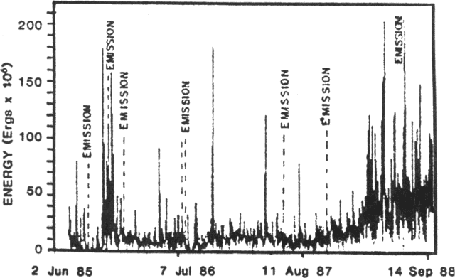 |
Figure 18. Seismic energy release at Ruiz, June 1985-September 1988. Periods of tephra emission are labeled. Courtesy of the Observatorio Vulcanológico de Colombia. |
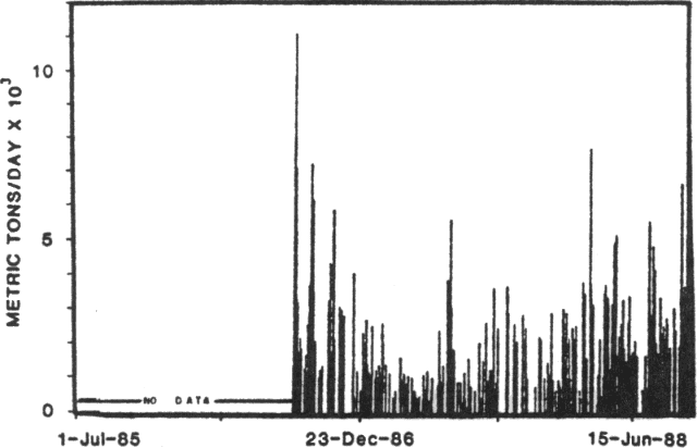 |
Figure 19. Daily SO2 flux as measured by COSPEC at Ruiz, mid-1986 to September 1988. Courtesy of the Observatorio Vulcanológico de Colombia. |
Geological Summary. Nevado del Ruiz is a broad, glacier-covered volcano in central Colombia that covers more than 200 km2. Three major edifices, composed of andesitic and dacitic lavas and andesitic pyroclastics, have been constructed since the beginning of the Pleistocene. The modern cone consists of a broad cluster of lava domes built within the caldera of an older edifice. The 1-km-wide, 240-m-deep Arenas crater occupies the summit. The prominent La Olleta pyroclastic cone located on the SW flank may also have been active in historical time. Steep headwalls of massive landslides cut the flanks. Melting of its summit icecap during historical eruptions, which date back to the 16th century, has resulted in devastating lahars, including one in 1985 that was South America's deadliest eruption.
Information Contacts: C. Carvajal, INGEOMINAS, Manizales.