Report on Nevado del Ruiz (Colombia) — November 1988

Scientific Event Alert Network Bulletin, vol. 13, no. 11 (November 1988)
Managing Editor: Lindsay McClelland.
Nevado del Ruiz (Colombia) Seismic energy release remains high
Please cite this report as:
Global Volcanism Program, 1988. Report on Nevado del Ruiz (Colombia) (McClelland, L., ed.). Scientific Event Alert Network Bulletin, 13:11. Smithsonian Institution. https://doi.org/10.5479/si.GVP.SEAN198811-351020
Nevado del Ruiz
Colombia
4.892°N, 75.324°W; summit elev. 5279 m
All times are local (unless otherwise noted)
Energy released in November by high- and low-frequency earthquakes and volcanic tremor remained similar to October values. A tremor episode on 23 November was associated with fumarolic activity and a brief landslide in the canyon of the Río Azufrado, 2 km NE of the crater (figure 21).
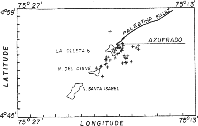 |
Figure 21. Epicenters of high-frequency earthquakes, November 1988, and the position of the Palestina Fault. Courtesy of the Observatorio Vulcanológico de Colombia. |
Although the tremor episode lasted only a few minutes, it produced one of the largest displacements of the energy release curve since 1986. A slight increase in seismicity followed for the next few hours. The month's main high-frequency activity was centered parallel to the regional Palestina Fault, occurring in two clusters. Depths were between 0.5 and 6 km. No significant deformation was measured during the month.
Geological Summary. Nevado del Ruiz is a broad, glacier-covered volcano in central Colombia that covers more than 200 km2. Three major edifices, composed of andesitic and dacitic lavas and andesitic pyroclastics, have been constructed since the beginning of the Pleistocene. The modern cone consists of a broad cluster of lava domes built within the caldera of an older edifice. The 1-km-wide, 240-m-deep Arenas crater occupies the summit. The prominent La Olleta pyroclastic cone located on the SW flank may also have been active in historical time. Steep headwalls of massive landslides cut the flanks. Melting of its summit icecap during historical eruptions, which date back to the 16th century, has resulted in devastating lahars, including one in 1985 that was South America's deadliest eruption.
Information Contacts: C. Carvajal, INGEOMINAS, Manizales.