Report on Ruapehu (New Zealand) — December 1988

Scientific Event Alert Network Bulletin, vol. 13, no. 12 (December 1988)
Managing Editor: Lindsay McClelland.
Ruapehu (New Zealand) Crater lake eruption ejects ash and blocks
Please cite this report as:
Global Volcanism Program, 1988. Report on Ruapehu (New Zealand) (McClelland, L., ed.). Scientific Event Alert Network Bulletin, 13:12. Smithsonian Institution. https://doi.org/10.5479/si.GVP.SEAN198812-241100
Ruapehu
New Zealand
39.28°S, 175.57°E; summit elev. 2797 m
All times are local (unless otherwise noted)
The longest recorded period of low Crater Lake temperatures was interrupted by a moderate eruption on 8 December. Earthquakes started at 0843 that morning after a month of weak seismicity [but see 14:01]. The third event, at 0903, was followed by the onset of 2-Hz tremor. Just 1-2 minutes before the 6th and strongest earthquake (M [3.6]) at [1011], white steam clouds rose in 2-3 pulses to a short distance above the crater lake before being blown NE by strong winds. No ash was evident in the clouds but a thin veneer of dark gray wet ash extended 1.1 km NE of the crater lake (figure 8). Swirling patterns and feathered edges in the airfall zone suggested deposition from a turbulent cloud. Most blocks fell within 100 m of the lake, producing many impact and melt craters up to 1 m across. Most of the blocks consisted of altered andesite; no juvenile bombs were found. No fresh glass was evident in samples of fine-grained tephra. The ash was dominantly silty silica particles and aggregates mixed with solid sulfur globules and spheroids, plus a few fine andesite grains and plagioclase fragments. Ash and water on the upper Whangaehu Glacier formed a small mudflow, only a few meters wide, that extended ~500 m downslope.
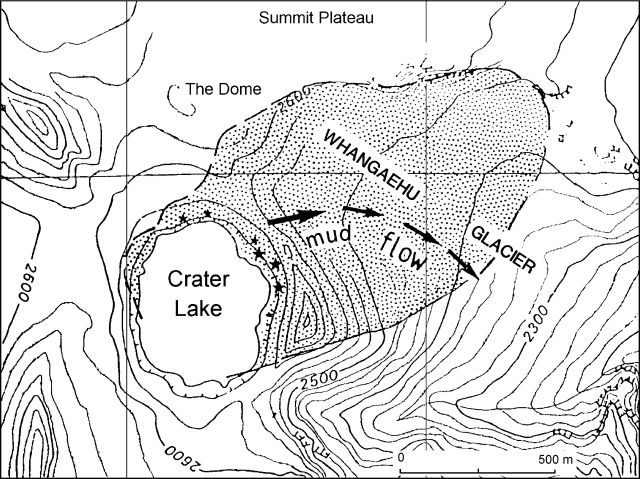 |
Figure 8. Ashfall (stippled), mudflow (arrows), and sites of greatest block concentrations (stars) from the 8 December 1988 eruption of Ruapehu. |
Lake temperature was 13.7°C the day after the eruption, only slightly above the record low of 9° measured during previous fieldwork on 14 November. Only minor deformation changes had occurred since 14 November. Semi-continuous to continuous 2-Hz tremor was observed on seismic records through 12 December, and 8-10 low-frequency earthquakes occurred 9-10 December.
Geological Summary. Ruapehu, one of New Zealand's most active volcanoes, is a complex stratovolcano constructed during at least four cone-building episodes dating back to about 200,000 years ago. The dominantly andesitic 110 km3 volcanic massif is elongated in a NNE-SSW direction and surrounded by another 100 km3 ring plain of volcaniclastic debris, including the NW-flank Murimoto debris-avalanche deposit. A series of subplinian eruptions took place between about 22,600 and 10,000 years ago, but pyroclastic flows have been infrequent. The broad summait area and flank contain at least six vents active during the Holocene. Frequent mild-to-moderate explosive eruptions have been recorded from the Te Wai a-Moe (Crater Lake) vent, and tephra characteristics suggest that the crater lake may have formed as recently as 3,000 years ago. Lahars resulting from phreatic eruptions at the summit crater lake are a hazard to a ski area on the upper flanks and lower river valleys.
Information Contacts: I. Nairn, P. Otway, B. Scott, and C. Wood, NZGS Rotorua; S. Sherburn and B. Christenson, DSIR Chemistry, Wairakei.