Report on Nevado del Ruiz (Colombia) — January 1989

Scientific Event Alert Network Bulletin, vol. 14, no. 1 (January 1989)
Managing Editor: Lindsay McClelland.
Nevado del Ruiz (Colombia) Seismic energy and number of event increase
Please cite this report as:
Global Volcanism Program, 1989. Report on Nevado del Ruiz (Colombia) (McClelland, L., ed.). Scientific Event Alert Network Bulletin, 14:1. Smithsonian Institution. https://doi.org/10.5479/si.GVP.SEAN198901-351020
Nevado del Ruiz
Colombia
4.892°N, 75.324°W; summit elev. 5279 m
All times are local (unless otherwise noted)
During January, total seismic energy release increased (figure 24a), as did the number of low- and high-frequency events (figure 24b). Most of the high-frequency seismicity was centered in an elongate NW-SE zone between Arenas Crater and Nevado del Cisne (figure 25). Focal depths generally ranged from 0.5 to 4.5 km. Swarms of long-period events occurred on the 17th and 29th, but their energy release was relatively low. Brief increases in the intensity of shallow tremor were usually associated with small ash emissions. A different type of tremor occurred 2-3 January; with a monochromatic signal, a dominant period of 0.35-0.45 seconds, and low energy. During the month, deformation did not exceed 10 µrad except at Molinas station (4 km NW of Arenas crater), which was affected by rainfall.
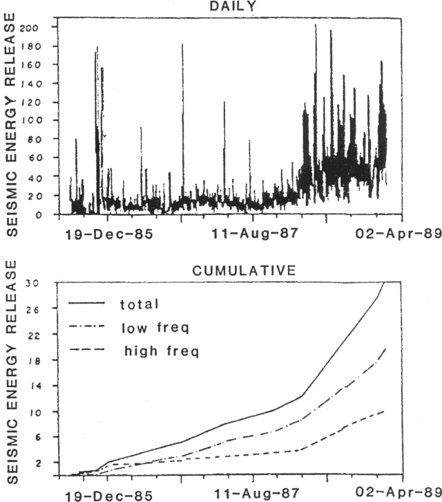 |
Figure 24. Cumulative seismic energy release at Ruiz, June 1985-January 1989. |
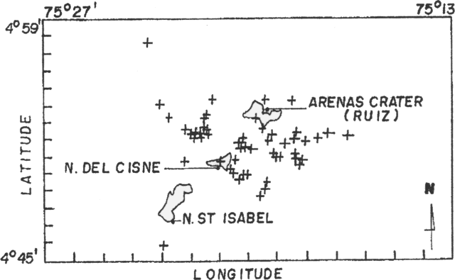 |
Figure 25. Locations of high-frequency events at Ruiz, January 1989. |
Geological Summary. Nevado del Ruiz is a broad, glacier-covered volcano in central Colombia that covers more than 200 km2. Three major edifices, composed of andesitic and dacitic lavas and andesitic pyroclastics, have been constructed since the beginning of the Pleistocene. The modern cone consists of a broad cluster of lava domes built within the caldera of an older edifice. The 1-km-wide, 240-m-deep Arenas crater occupies the summit. The prominent La Olleta pyroclastic cone located on the SW flank may also have been active in historical time. Steep headwalls of massive landslides cut the flanks. Melting of its summit icecap during historical eruptions, which date back to the 16th century, has resulted in devastating lahars, including one in 1985 that was South America's deadliest eruption.
Information Contacts: C. Carvajal and F. Muñoz, INGEOMINAS, Manizales.