Report on Galeras (Colombia) — April 1989

Scientific Event Alert Network Bulletin, vol. 14, no. 4 (April 1989)
Managing Editor: Lindsay McClelland.
Galeras (Colombia) Ash emission and strong seismicity; area residents alerted
Please cite this report as:
Global Volcanism Program, 1989. Report on Galeras (Colombia) (McClelland, L., ed.). Scientific Event Alert Network Bulletin, 14:4. Smithsonian Institution. https://doi.org/10.5479/si.GVP.SEAN198904-351080
Galeras
Colombia
1.22°N, 77.37°W; summit elev. 4276 m
All times are local (unless otherwise noted)
Frequent ash ejection in early May was accompanied by increased seismicity (figure 1) and SO2 emission. The strong seismic swarm that began 5 April at 1000 and saturated one seismograph was not associated with eruptive activity. COSPEC measurements the next day showed a sharp rise in SO2 emission to >1,200 metric tons/day (t/d) from 30-40 t/d 19-20 March [SO2 flux rose above 1,000 t/d on four days in April, see figure 12]. Glow was observed within the active (El Pinta) vent and by mid-April rocks 2 m below the rim had reached almost 600°C. The seismic swarm and glow prompted officials to increase the alert status to "yellow." A hazard map was published in a local newspaper and residents of areas designated as hazardous were urged to move, if possible, to a safer region. As of late April, a dense water-rich gas plume continued to rise 1-2 km above the crater and low-level seismicity persisted, but no deformation was evident.
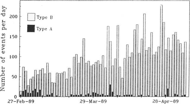 |
Figure 1. Number of recorded seismic events at Galeras, 27 February-5 May 1989. Courtesy of the Observatorio Vulcanológico de Colombia and the USGS Volcano Disaster Assistance Program. |
4-5 May. After 10 hours of gradual increases in both background tremor (<1 mm peak to peak) and small long-period seismic events, ash was erupted between 0613 and 0830 on 4 May. Although emission rates were low, column heights reached 3.3 km. Ash composed of lithic particles and some plagioclase crystals fell towards the SW and E; a light dusting of ash fell on Pasto (population 350,000) at the volcano's E foot. Seismicity fluctuated between low and moderate levels for the next 11 hours before ash emission resumed at 1743. There were no recognizable immediate seismic precursors but the onset of the activity was accompanied by increased tremor. The rate of ash emission was again low, with the column pulsing at times to 2.9 km height. Both the plume and tremor diminished to low levels at 1855, but ash emission continued until 1940. Most of the ash was blown SW, and 1 mm of dust-sized tephra fell on Consaca, roughly 13 km WSW of the vent. EDM lines showed no change during the activity.
The ash eruption resumed at 0638, accompanied by an impulsive seismic signal, and tremor increased rapidly to an average peak-to-peak amplitude of 2 mm. The column grew to 1.2 km height by 0712, 1.9 km by 0726, and stabilized as a pulsing column to 2.8 km height between 0728 and 0825. The eruption column and tremor then decreased rapidly to low levels. The plume was broad and dense, dropping sheets of ash mainly within a few kilometers W of the vent. On the vent's E rim, the new deposit was ~25 cm thick, with the first layer a wet mud, probably from the lake that had occupied the bottom of the vent. Surge units were found in the deposit, as were lithic blocks that averaged about 15 cm in diameter. Only a thin film of ash fell at Consaca and other areas to the W and SW. However, the press reported that rescue workers evacuated ~2,000 residents of the Consacá area because of the ashfall. Activity around 1100 was accompanied by pulses of 4-5-Hz tremor and some long-period events. Ash was blown to the N, falling over La Florida and Nariño (8 km NNW and 7.5 km N of the vent). The EDM line across the caldera showed no change after the 4-5 May activity, but there may have been slight deflation on lines from the caldera rim to the active cone.
6 May. Ash emission resumed on 6 May at about 0900, producing a broad, pulsing column that fluctuated between 2.5 and 3.2 km height until darkness prevented further observations (about 1800). The rate of ash emission was intermediate between that of 4 May and the more vigorous activity of 5 May. Only low-level tremor and occasional long-period events accompanied the 6 May activity.
7-9 May. Harmonic tremor (1.3-1.4 Hz) began on 7 May at 0730 and continued for 38 minutes. Amplitudes reached 5 mm peak-to-peak and the tremor could be detected throughout the seismic net to 10 km from the vent. A similar signal reappeared at 0900, lasting for 40 minutes, and a pattern of intermittent tremor continued until 1400, with each episode building to larger amplitudes (as much as 1.5 cm peak-to-peak). The tremor typically occurred in 1.35-Hz packets with wavelengths of 10 seconds. The next-to-last tremor episode ceased abruptly after two large A-type events were recorded. During the last and strongest episode, many small A-type shocks were imbedded in the tremor. The A-type events were centered 3-3.5 km below the vent and 1-7 km to its S. The strong tremor was succeeded by bands of higher frequency tremor with much lower amplitude (<1 mm peak-to-peak). Minor ash emission continued 7 and 8 May. Ash was blown N on 7 May but did not reach La Florida, Nariño, or Jenoy (6 km NNE of the vent). The 8 May ash fell only near the crater. Frequent tremor episodes continued 8 May: 45 minutes of 2-3-Hz tremor that began gradually at 0614; low-frequency (1.54 Hz) banded tremor that began at 0800 and reached 23 mm amplitude about noon, decreasing in amplitude around 1540; amplitude increased again at 1600, to 20 mm, before declining at 1650 and stabilizing at 2-3 mm. Tremor decreased gradually from 9 May at 2000, to a maximum of 1 mm amplitude. Ash emission then stopped, and eruptive activity had not resumed as of 16 May.
The five days of ash emission prompted school closings and an increase in alert status to "orange" on 9 May. No immediate evacuations were ordered but officials asked residents to be ready for instructions if an eruption occurs. The Galeras Volcano Workshop that began 8 May with 50 participants from Central and South America will study the activity and hazards response.
Tephra deposits. An area of ~33 km2 was enclosed within the 3 mm ashfall isopach, including the TELECOM and television sites, 1.5 km to the S, and Nariño, 7.5 km N of the crater. The volume of tephra deposits was calculated at ~4 x 10⁵ m3. The 7 cm of fine ash deposited at the S rim of El Pinta crater 19 February-3 May was overlain by more than 5 m of tephra that accumulated 4-9 May. A preliminary grain-size analysis shows a large fraction of fine (<1 mm) material (table 1). Some coarser layers of the early May tephra included scoria; in one layer (G) it was clearly altered, but in another horizon (E) it included abundant crystals in a very glassy matrix.
Table 1. Grain-size distribution of tephra deposited 4-9 May at Galeras, on the S rim of El Pinta crater. Thicknesses of individual layers (in cm) are supplemented by cumulative thickness of post-19 February tephra; only 7 cm of the section fell 19 February-3 May. The weight percent of six size fractions: <0.5, 0.5-1, 1-2, 2-4, 4-6.5, and >6.5 cm are shown. Courtesy of INGEOMINAS.
| Layer ID | Layer Thickness | Cumulative Thickness | 0-0.5 cm | 0.5-1 cm | 1-2 cm | 2-4 cm | 4-6.5 cm | 6.5+ cm |
| B | 3 cm | 501 cm | 26.6 | 32.2 | 27.3 | 8.6 | 5.5 | -- |
| C | 7 cm | 498 cm | 96.0 | 2.3 | 1.0 | 0.5 | 0.3 | -- |
| D | 12 cm | 491 cm | 44.6 | 27.3 | 20.4 | 6.1 | 1.6 | -- |
| E | 22 cm | 469 cm | 5.0 | 4.1 | 6.1 | 7.9 | 30.9 | 46.0 |
| F | 32 cm | 447 cm | 38.8 | 33.0 | 17.9 | 5.2 | 5.2 | -- |
| G | 43 cm | 415 cm | 6.9 | 8.1 | 7.5 | 6.5 | 6.5 | 24.1 |
Geological Summary. Galeras, a stratovolcano with a large breached caldera located immediately west of the city of Pasto, is one of Colombia's most frequently active volcanoes. The dominantly andesitic complex has been active for more than 1 million years, and two major caldera collapse eruptions took place during the late Pleistocene. Long-term extensive hydrothermal alteration has contributed to large-scale edifice collapse on at least three occasions, producing debris avalanches that swept to the west and left a large open caldera inside which the modern cone has been constructed. Major explosive eruptions since the mid-Holocene have produced widespread tephra deposits and pyroclastic flows that swept all but the southern flanks. A central cone slightly lower than the caldera rim has been the site of numerous small-to-moderate eruptions since the time of the Spanish conquistadors.
Information Contacts: H. Cepeda and B. Pulgarin, INGEOMINAS, Popayán; M. Calvache, F. Muñoz, and R. Méndez, INGEOMINAS, Manizales; I. Mejía and E. Parra, INGEOMINAS, Medellín; M. Mercado, Popayán; N. Banks, USGS; Deutche Presse-Agentur; Agence France-Presse.