Report on Galeras (Colombia) — August 1989

Scientific Event Alert Network Bulletin, vol. 14, no. 8 (August 1989)
Managing Editor: Lindsay McClelland.
Galeras (Colombia) Earthquake swarm; inflation; new fumaroles; more SO2
Please cite this report as:
Global Volcanism Program, 1989. Report on Galeras (Colombia) (McClelland, L., ed.). Scientific Event Alert Network Bulletin, 14:8. Smithsonian Institution. https://doi.org/10.5479/si.GVP.SEAN198908-351080
Galeras
Colombia
1.22°N, 77.37°W; summit elev. 4276 m
All times are local (unless otherwise noted)
Ash ejections declined in mid-May and had not resumed by early September. Seismic energy release and the number of volcanic events generally remained relatively stable in August and early September (figure 6). Relatively few high-frequency events were recorded until an increase began on 14 August, peaking on 25 August, associated with a 21-event swarm ~6 km NE of the crater at 12-15 km depth (figure 7). Similar events have also occurred near the crater at depths of 2-7 km. Low-frequency events declined slightly from July levels. Electronic tilt data showed inflationary changes of 100 µrad 2 km S of the crater at 3,900 m elevation (Telecom station) but only 4 µrad 2 km E of the crater at 3,800 m elevation (Peladitos station), possibly associated with a very shallow source. Neither EDM or dry tilt measurements showed significant changes. SO2 emissions increased through mid-August then declined slightly, yielding an average rate through 12 September of 1,046 t/d (see figure 12).
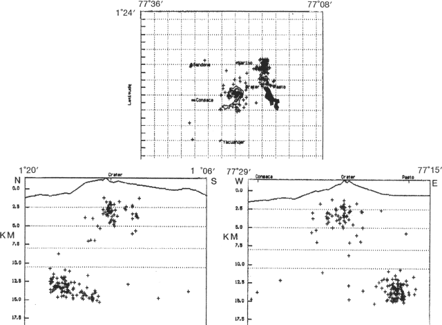 |
Figure 6. Daily seismic energy release, 21 February-9 September 1989, recorded by the Nariño station, 5 km from the crater at Galeras. Courtesy of INGEOMINAS. |
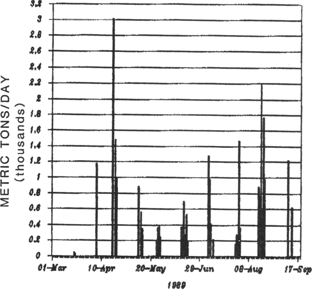 |
Figure 7. Epicenters (right) and N-S and E-W cross sections showing focal depths (below, left and right) of 164 seismic events near Galeras, August 1989. Note that the scales of the cross sections differ from the scale of the epicenter map by a factor of 2. Courtesy of INGEOMINAS. |
Geologists climbed into the crater on 5 September. Fumarolic activity was continuing to increase on the SW flank of the central cone, with the areas numbered 3, 4, and 8 (figure 8) showing expansion in size. The volume and pressure of gas emission increased since the last visit, as has the strong noise associated with the expulsion of superheated gases. Incandescence was observed within vents in the La Chava area (number 4 on figure 8) and an E-W fracture crossing the same area. The fracture had increased its width to 30 cm. A new fumarolic area (number 5) had developed on the W flank of the central cone, associated with radial and tangential fractures. The western inner flank of the main crater had also shown an increase in fumarolic activity. Deposits from small phreatic emissions were observed near the vents.
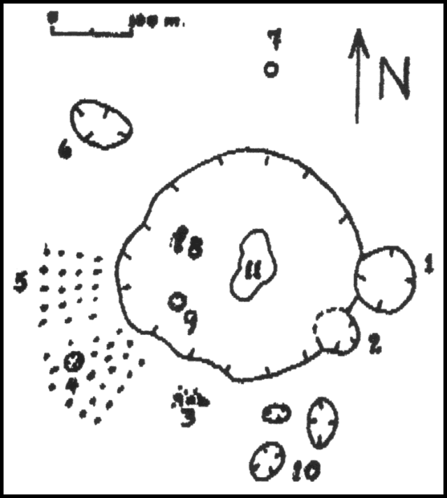 |
Figure 8. Sketch map of the summit area of Galeras during fieldwork 5 September 1989. Thermal features are numbered. Courtesy of INGEOMINAS. |
Geological Summary. Galeras, a stratovolcano with a large breached caldera located immediately west of the city of Pasto, is one of Colombia's most frequently active volcanoes. The dominantly andesitic complex has been active for more than 1 million years, and two major caldera collapse eruptions took place during the late Pleistocene. Long-term extensive hydrothermal alteration has contributed to large-scale edifice collapse on at least three occasions, producing debris avalanches that swept to the west and left a large open caldera inside which the modern cone has been constructed. Major explosive eruptions since the mid-Holocene have produced widespread tephra deposits and pyroclastic flows that swept all but the southern flanks. A central cone slightly lower than the caldera rim has been the site of numerous small-to-moderate eruptions since the time of the Spanish conquistadors.
Information Contacts: INGEOMINAS, Pasto; INGEOMINAS, Manizales.