Report on Ahyi (United States) — December 1989
Scientific Event Alert Network Bulletin, vol. 14, no. 12 (December 1989)
Managing Editor: Lindsay McClelland.
Ahyi (United States) Renewed activity at September 1989 site
Please cite this report as:
Global Volcanism Program, 1989. Report on Ahyi (United States) (McClelland, L., ed.). Scientific Event Alert Network Bulletin, 14:12. Smithsonian Institution. https://doi.org/10.5479/si.GVP.SEAN198912-284141
Ahyi
United States
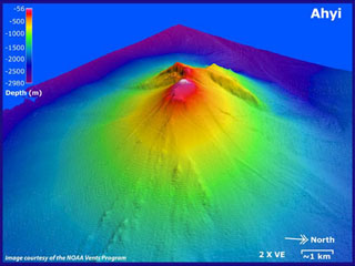
20.42°N, 145.03°E; summit elev. -75 m
All times are local (unless otherwise noted)
An ocean bottom seismometer off the Boso Peninsula, Japan, and hydrophones on Wake Island detected renewed episodes of apparent submarine volcanism on 22-24 and 26-27 December. Arrival directions and times were very similar to those from the 21-22 September activity, and probably originated from the same area.
Seismicity began to be recorded by the Boso Peninsula instrument on 22 December at about 0630, and events soon became frequent, although intervals between events were slightly longer than in September. Seismicity had nearly ended shortly before 0200 on 24 December, although one additional shock was recorded at 0245. T-phase signals resumed on 26 December at about 1600 and continued until about 2300 the next day, but occurred at significantly longer intervals than the two earlier episodes.
Using more precise sound velocities, Univ of Hawaii geophysicists refined the locations of the 21-22 September events to about 20.3°N, 144.9°E, roughly 30 km S of... Farallon de Pajaros (Uracas). The potential location error remains large, but is oriented along a NE-SW line oblique to the volcanic chain. The 21-22 September locations are very close to the site of... a 3-km zone of discolored water that was observed in September 1985 near the 1969 eruption site.
[Report reviewed and attributed to Ahyi in 2023.]
Geological Summary. Ahyi seamount is a large conical submarine volcano that rises to within 75 m of the ocean surface ~18 km SE of the island of Farallon de Pajaros in the northern Marianas. Water discoloration has been observed there, and in 1979 the crew of a fishing boat felt shocks over the summit area, followed by upwelling of sulfur-bearing water. On 24-25 April 2001 an explosive eruption was detected seismically by a station on Rangiroa Atoll, Tuamotu Archipelago. The event was well constrained (+/- 15 km) at a location near the southern base of Ahyi. An eruption in April-May 2014 was detected by NOAA divers, hydroacoustic sensors, and seismic stations.
Information Contacts: Y. Sawada, JMA; C. McCreery and D. Walker, Univ of Hawaii.