Report on Llaima (Chile) — 1 April-7 April 2009
Smithsonian Institution / US Geological Survey
Weekly Volcanic Activity Report, 1 April-7 April 2009
Managing Editor: Sally Sennert.
Please cite this report as:
Global Volcanism Program, 2009. Report on Llaima (Chile) (Sennert, S, ed.). Weekly Volcanic Activity Report, 1 April-7 April 2009. Smithsonian Institution and US Geological Survey.
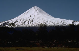
Llaima
Chile
38.692°S, 71.729°W; summit elev. 3125 m
All times are local (unless otherwise noted)
During 2-3 April, SERNAGEOMIN reported that seismicity from Llaima increased in frequency and amplitude and evolved into continuous seismic tremor. Steam plumes with small amounts of ash were emitted. Late in the day on 3 April, observers reported incandescence from the main crater. Weak Strombolian explosions were produced by the N cone inside the crater. On 4 April, Strombolian activity and rhythmic explosions in the main crater originated from two nested pyroclastic cones. Incandescent tephra was ejected 700 m above the crater. The Alert Level was raised to Red. ONEMI reported that fine ash fell in Verde Lake in the Conguillío National Park (a 608 square kilometer park containing Llaima) and a lava flow 1 km long traveled W towards the Calbuco River. Access to local parks was restricted and twelve people self-evacuated. Later that day, authorities ordered an evacuation for people in high-risk areas, mainly due to the potential for lahars along the Calbuco River. According to news articles, 71 people evacuated.
SERNAGEOMIN reported that Strombolian activity continued on 5 April. A dark gray ash plume drifted E; heavy ashfall was reported in Lago Verde. A lahar traveled down the Captrén River (NNE) and lava continued to travel down the W flank. On 6 April, poor weather mostly prevented visual observations, but continuous explosions were reported from Melipeuco (about 17 km SSE). Lahars again traveled down the Captrén River. Occasionally, gas-and-ash plumes were seen and drifted E; ash fell in areas E. Heavy ashfall and lapilli up to 1.5 cm in diameter fell in areas between Conguillio Lake (about 10 km ENE, in Conguillío National Park) and the Arcoiris Lake (less than 10 km ENE, in Conguillío National Park). On 7 April, gas and ash emitted from multiple points formed a plume that rose 1 km above the summit and drifted NE. The flanks of the volcano were covered with bombs, lapilli, and ash.
Geological Summary. Llaima, one of Chile's largest and most active volcanoes, contains two main historically active craters, one at the summit and the other, Pichillaima, to the SE. The massive, dominantly basaltic-to-andesitic, stratovolcano has a volume of 400 km3. A Holocene edifice built primarily of accumulated lava flows was constructed over an 8-km-wide caldera that formed about 13,200 years ago, following the eruption of the 24 km3 Curacautín Ignimbrite. More than 40 scoria cones dot the volcano's flanks. Following the end of an explosive stage about 7200 years ago, construction of the present edifice began, characterized by Strombolian, Hawaiian, and infrequent subplinian eruptions. Frequent moderate explosive eruptions with occasional lava flows have been recorded since the 17th century.
Sources: Servicio Nacional de Geología y Minería (SERNAGEOMIN), Oficina Nacional de Emergencia-Ministerio del Interior (ONEMI), Reuters