Report on Cerro Hudson (Chile) — 16 November-22 November 2011
Smithsonian Institution / US Geological Survey
Weekly Volcanic Activity Report, 16 November-22 November 2011
Managing Editor: Sally Sennert.
Please cite this report as:
Global Volcanism Program, 2011. Report on Cerro Hudson (Chile) (Sennert, S, ed.). Weekly Volcanic Activity Report, 16 November-22 November 2011. Smithsonian Institution and US Geological Survey.
Cerro Hudson
Chile
45.9°S, 72.97°W; summit elev. 1905 m
All times are local (unless otherwise noted)
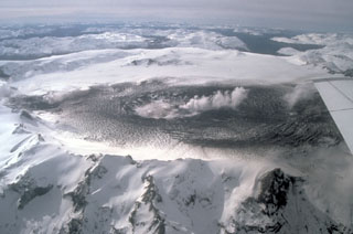
OVDAS-SERNAGEOMIN reported that satellite imagery and an area web camera showed no plumes rising from Cerro Hudson during 7-15 November. Seismic activity decreased significantly, reaching a low level characterized by no more than four earthquakes per hour and the absence of tremor. The Alert Level remained at Yellow, Level 4.
Geological Summary. The ice-filled, 10-km-wide caldera of Cerro Hudson volcano was not recognized until its first 20th-century eruption in 1971. It is the southernmost volcano in the Chilean Andes, related to subduction of the Nazca plate beneath the South American plate. The massive volcano covers an area of 300 km2. The compound caldera is drained through a breach on its NW rim, which has been the source of mudflows down the Río de Los Huemeles. Two cinder cones occur N of the volcano and others occupy the SW and SE flanks. This volcano has been the source of several major Holocene explosive eruptions. An eruption about 6,700 years ago was one of the largest known in the southern Andes during the Holocene; another eruption about 3,600 years ago also produced more than 10 km3 of tephra. An eruption in 1991 formed a new 800-m-wide crater in the SW portion of the caldera.
Source: Servicio Nacional de Geología y Minería (SERNAGEOMIN)