Report on Kanaga (United States) — 22 February-28 February 2012
Smithsonian Institution / US Geological Survey
Weekly Volcanic Activity Report, 22 February-28 February 2012
Managing Editor: Sally Sennert.
Please cite this report as:
Global Volcanism Program, 2012. Report on Kanaga (United States) (Sennert, S, ed.). Weekly Volcanic Activity Report, 22 February-28 February 2012. Smithsonian Institution and US Geological Survey.
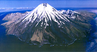
Kanaga
United States
51.923°N, 177.168°W; summit elev. 1307 m
All times are local (unless otherwise noted)
AVO reported that no unusual activity was detected in seismic data or in partly-cloudy satellite images of Kanaga during 22-24 and 26-28 February. Low-level volcanic tremor was detected on 25 February. The Volcano Alert Level remained at Advisory and the Aviation Color Code remained at Yellow.
Geological Summary. Symmetrical Kanaga stratovolcano is situated within the Kanaton caldera at the northern tip of Kanaga Island. The caldera rim forms a 760-m-high arcuate ridge south and east of Kanaga; a lake occupies part of the SE caldera floor. The volume of subaerial dacitic tuff is smaller than would typically be associated with caldera collapse, and deposits of a massive submarine debris avalanche associated with edifice collapse extend nearly 30 km to the NNW. Several fresh lava flows from historical or late prehistorical time descend the flanks of Kanaga, in some cases to the sea. Historical eruptions, most of which are poorly documented, have been recorded since 1763. Kanaga is also noted petrologically for ultramafic inclusions within an outcrop of alkaline basalt SW of the volcano. Fumarolic activity occurs in a circular, 200-m-wide, 60-m-deep summit crater and produces vapor plumes sometimes seen on clear days from Adak, 50 km to the east.
Source: US Geological Survey Alaska Volcano Observatory (AVO)