Report on Osorno (Chile) — 2 May-8 May 2018
Smithsonian Institution / US Geological Survey
Weekly Volcanic Activity Report, 2 May-8 May 2018
Managing Editor: Sally Sennert.
Please cite this report as:
Global Volcanism Program, 2018. Report on Osorno (Chile) (Sennert, S, ed.). Weekly Volcanic Activity Report, 2 May-8 May 2018. Smithsonian Institution and US Geological Survey.
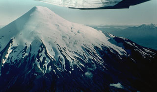
Osorno
Chile
41.105°S, 72.496°W; summit elev. 2659 m
All times are local (unless otherwise noted)
Servicio Nacional de Geología and Minería (SERNAGEOMIN) Observatorio Volcanológico de Los Andes del Sur (OVDAS) raised the Alert Level for Osorno to Yellow (the second lowest level on a four-color scale) on 8 May, due to a gradual increase in the number and magnitude of seismic events recorded during 1-30 April. Earthquakes were concentrated on the NNW flank. The largest of the 294 total events was a M 3, located 2 km NW of the crater at a depth of 3.3 km.
Geological Summary. The symmetrical, glaciated, Osorno volcano towers above Todos los Santos and Llanquihué lakes. It was constructed over the SW part of a roughly 250,000-year-old eroded stratovolcano, La Picada, that has a mostly buried 6-km-wide caldera. The dominantly basaltic to basaltic andesite volcano includes two small dacitic lava domes on the NW and SSE flanks. Flank scoria cones and fissure vents, primarily on the W and SW sides, have produced lava flows that reached Lago Llanquihué. Frequent explosive eruptions including pyroclastic flows and surges have occurred during the past 14,000 years. Recorded eruptions have originated from summit and flank vents, producing basaltic and andesitic lava flows that have entered both Llanquihué and Todos los Santos lakes.
Sources: Oficina Nacional de Emergencia-Ministerio del Interior (ONEMI), Servicio Nacional de Geología y Minería (SERNAGEOMIN)