Report on Takawangha (United States) — 8 March-14 March 2023
Smithsonian Institution / US Geological Survey
Weekly Volcanic Activity Report, 8 March-14 March 2023
Managing Editor: Sally Sennert.
Please cite this report as:
Global Volcanism Program, 2023. Report on Takawangha (United States) (Sennert, S, ed.). Weekly Volcanic Activity Report, 8 March-14 March 2023. Smithsonian Institution and US Geological Survey.
Takawangha
United States
51.873°N, 178.006°W; summit elev. 1449 m
All times are local (unless otherwise noted)
AVO reported that the earthquake swarm at Takawangha that began in November 2022 started to decline on 1 March. Seismicity abruptly increased again on 8 March and was sustained, with M4 or lower earthquakes occurring at depths of less than about 6 km below sea level. Earthquake activity beneath Takawangha volcano and nearby Tanaga Volcano (8 km W), both on Tanaga Island, continued at a high rate during 8-9 March, with more than 100 events per hour at times. Sustained seismicity indicated an increased potential for an eruption, so AVO raised the Volcano Alert Level for Takawangha to Watch (the second highest level on a four-level scale) and the Aviation Color Code to Orange (the second highest level on a four-color scale) at 1722 on 9 March. It was uncertain which volcano would erupt, if an eruption were to occur, so the Volcano Alert Level and Aviation Color Code for Tanaga were also raised to the same level. Earthquakes beneath Tanaga and Takawangha occurred at a rate of up to several events per minute during 10-11 March and at a slightly reduced rate during 12-14 March. The earthquakes had magnitudes up to about 4 and were mostly occurring at depths less than about 6 km.
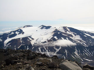
Geological Summary. Takawangha is a youthful volcano with an ice-filled caldera on northern Tanaga Island, near the western end of the Andreanof Islands. It lies across a saddle from historically active Tanaga volcano to the west; older, deeply eroded volcanoes lie adjacent to the east. The summit of the dominantly basaltic to basaltic-andesite volcano is largely ice covered, with the exception of five Holocene craters that during the last few thousand years produced explosive eruptions and lava flows that reached the lower flanks. No historical eruptions are known, although radiocarbon dating indicates explosive eruptions have occurred within the past several hundred years.
Source: US Geological Survey Alaska Volcano Observatory (AVO)