Report on Ahyi (United States) — 14 June-20 June 2023
Smithsonian Institution / US Geological Survey
Weekly Volcanic Activity Report, 14 June-20 June 2023
Managing Editor: Sally Sennert.
Please cite this report as:
Global Volcanism Program, 2023. Report on Ahyi (United States) (Sennert, S, ed.). Weekly Volcanic Activity Report, 14 June-20 June 2023. Smithsonian Institution and US Geological Survey.
Ahyi
United States
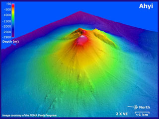
20.42°N, 145.03°E; summit elev. -75 m
All times are local (unless otherwise noted)
Unrest at Ahyi Seamount possibly continued during 13-20 June. A few small hydroacoustic signals coming from the direction of the seamount were detected by pressure sensors on Wake Island (2,270 km E) during 16-17 June. No surface activity was visible in satellite images. The Aviation Color Code remained at Yellow (the second lowest level on a four-color scale) and the Volcano Alert Level remained at Advisory (the second lowest level on a four-level scale).
Geological Summary. Ahyi seamount is a large conical submarine volcano that rises to within 75 m of the ocean surface ~18 km SE of the island of Farallon de Pajaros in the northern Marianas. Water discoloration has been observed there, and in 1979 the crew of a fishing boat felt shocks over the summit area, followed by upwelling of sulfur-bearing water. On 24-25 April 2001 an explosive eruption was detected seismically by a station on Rangiroa Atoll, Tuamotu Archipelago. The event was well constrained (+/- 15 km) at a location near the southern base of Ahyi. An eruption in April-May 2014 was detected by NOAA divers, hydroacoustic sensors, and seismic stations.
Source: US Geological Survey