Report on Suwanosejima (Japan) — 28 February-5 March 2024
Smithsonian Institution / US Geological Survey
Weekly Volcanic Activity Report, 28 February-5 March 2024
Managing Editor: Sally Sennert.
Please cite this report as:
Global Volcanism Program, 2024. Report on Suwanosejima (Japan) (Sennert, S, ed.). Weekly Volcanic Activity Report, 28 February-5 March 2024. Smithsonian Institution and US Geological Survey.
Suwanosejima
Japan
29.638°N, 129.714°E; summit elev. 796 m
All times are local (unless otherwise noted)
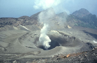
JMA reported that the eruption at Suwanosejima's Ontake Crater continued during 26 February-4 March. Crater incandescence was observed in webcam images nightly and large blocks were sometimes ejected up to 600 m from the vent. Explosions recorded at 0431, 1402, 1910, and 1918 on 26 February, and at 0135, 0249, and 0617 on 27 February produced ash plumes that rose 500-800 m above the crater rim and drifted S. An eruptive event at 0104 on 28 February produced an ash plume that rose 1.4 km above the crater rim and drifted S. Explosions at 1537 on 28 February and 0013 on 2 March generated ash plumes that rose 500-600 m and drifted W and SE, respectively. An explosion was recorded at 0255 on 1 March but emission details were unknown. Ash plumes from eruptive events at 1530 on 3 March and 0905 on 4 March produced ash plumes that rose 800-1,300 m above the crater rim; the 3 March plume rose into weather clouds. Ashfall was reported in Toshima village (3.5 km SSW), though dates were not specified. The Alert Level remained at 2 (on a 5-level scale) and the public was warned to stay at least 1 km away from the crater.
Geological Summary. The 8-km-long island of Suwanosejima in the northern Ryukyu Islands consists of an andesitic stratovolcano with two active summit craters. The summit is truncated by a large breached crater extending to the sea on the E flank that was formed by edifice collapse. One of Japan's most frequently active volcanoes, it was in a state of intermittent Strombolian activity from Otake, the NE summit crater, between 1949 and 1996, after which periods of inactivity lengthened. The largest recorded eruption took place in 1813-14, when thick scoria deposits covered residential areas, and the SW crater produced two lava flows that reached the western coast. At the end of the eruption the summit of Otake collapsed, forming a large debris avalanche and creating an open collapse scarp extending to the eastern coast. The island remained uninhabited for about 70 years after the 1813-1814 eruption. Lava flows reached the eastern coast of the island in 1884. Only about 50 people live on the island.