Report on Ruang (Indonesia) — 10 April-16 April 2024
Smithsonian Institution / US Geological Survey
Weekly Volcanic Activity Report, 10 April-16 April 2024
Managing Editor: Sally Sennert.
Please cite this report as:
Global Volcanism Program, 2024. Report on Ruang (Indonesia) (Sennert, S, ed.). Weekly Volcanic Activity Report, 10 April-16 April 2024. Smithsonian Institution and US Geological Survey.
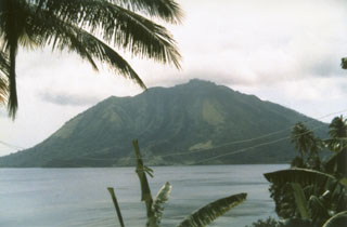
Ruang
Indonesia
2.3°N, 125.37°E; summit elev. 725 m
All times are local (unless otherwise noted)
PVMBG reported that the number of deep volcanic earthquakes at Ruang increased each day during 10-15 April, with the total number significantly higher than from the entire month of March. During the morning of 16 April dense white plumes were visible rising 200-500 m above the summit and seismicity intensified. At 1000 on 16 April the Alert Level was raised to 2 (on a scale of 1-4) and the public was warned to stay 2 km away from the crater.
A minor eruption began at around 1337 on 16 April. The Darwin VAAC noted that an ash plume was visible in a satellite image rising to 1.2 km (4,000 ft) a.s.l. and drifting SSW. At 1600 the Alert Level was raised to 3. According to a news article a larger eruption began at 2045 and ash plumes rose 2 km. The eruption intensified overnight during 16-17 April. The Darwin VAAC report that at 0230 on 17 April ash plumes rose to 9.1 km (30,000 ft) a.s.l. and drifted W; another plume at 0300 reached 12.2 km (40,000 ft) a.s.l. and detached from the summit. Ash plumes at a lower altitude, 4.6 km (15,000 ft) a.s.l., drifted WSW. At 0600 ash plumes rose to 13.7 km (45,000 ft) a.s.l. and drifted W and NW. The plume was detached from the summit by 0713. BNPB reported that 828 people evacuated and the communication network in Laingpatehi village was not operational. Photos showed incandescent material being ejected above the summit, incandescent material on the flanks, and dense ash plumes with lightning rising into dark, nighttime skies.
Geological Summary. Ruang volcano is the southernmost volcano in the Sangihe Island arc, north of Sulawesi Island; it is not the better known Raung volcano on Java. The 4 x 5 km island volcano is across a narrow strait SW of the larger Tagulandang Island. The summit contains a crater partially filled by a lava dome initially emplaced in 1904. Explosive eruptions recorded since 1808 have often been accompanied by lava dome formation and pyroclastic flows that have damaged inhabited areas.
Sources: Pusat Vulkanologi dan Mitigasi Bencana Geologi (PVMBG, also known as CVGHM), Badan Nacional Penanggulangan Bencana (BNPB), Jakarta Post, Darwin Volcanic Ash Advisory Centre (VAAC)