According to news articles, Enzo Boschi, the head of INGV, stated that seismicity increased near Campi Flegrei Mar Sicilia a group of submarine volcanoes ~30 km S of Sicily, near Tunisia. Boschi stated, "The island could come back to the surface, but we'll have to wait and see... It could be a few weeks or months." The Stromboli On-Line website noted that similar statements have been made several times in the past couple of years. The increased seismicity does not necessarily signify that an eruption is imminent and the island will re-emerge above wave base.
Sources: Stromboli On-Line, Reuters
2002: November
According to news articles, Enzo Boschi, the head of INGV, stated that seismicity increased near Campi Flegrei Mar Sicilia a group of submarine volcanoes ~30 km S of Sicily, near Tunisia. Boschi stated, "The island could come back to the surface, but we'll have to wait and see... It could be a few weeks or months." The Stromboli On-Line website noted that similar statements have been made several times in the past couple of years. The increased seismicity does not necessarily signify that an eruption is imminent and the island will re-emerge above wave base.
Sources: Stromboli On-Line; Reuters
The Global Volcanism Program has no Bulletin Reports available for Campi Flegrei del Mar di Sicilia.
This compilation of synonyms and subsidiary features may not be comprehensive. Features are organized into four major categories: Cones, Craters, Domes, and Thermal Features. Synonyms of features appear indented below the primary name. In some cases additional feature type, elevation, or location details are provided.
Synonyms |
||||
| Phlegraean Fields of the Sicily Sea | Campi Fleigrei Canale de Sicilia | ||||
Cones |
||||
| Feature Name | Feature Type | Elevation | Latitude | Longitude |
| Nerita Bank | Submarine cone | -142 m | 37° 5' 32" N | 12° 50' 20" E |
| Terribile Bank | Submarine cone | -19 m | 37° 9' 22" N | 12° 52' 32" E |
Craters |
||||
| Feature Name | Feature Type | Elevation | Latitude | Longitude |
| Anfitrite | Submarine crater | |||
| Cimotoe | Submarine crater | |||
|
Ferdinandea
Corrao Graham Island Graham Bank Ferdinandea Bank Hotham Nerita Scircca Giulia-Ferdinandeo |
Submarine crater | 37° 12' 0" N | 12° 42' 0" E | |
| Galatea | Submarine crater | |||
| Madrepore | Submarine crater | 36° 42' 0" N | 13° 42' 0" E | |
| Pantelleria Bank | Submarine crater | 37° 12' 0" N | 12° 6' 0" E | |
|
Pinne
Pinne Marine |
Submarine crater | -45 m | 37° 5' 37" N | 13° 6' 48" E |
| Smyt Bank I | Submarine crater | 37° 36' 0" N | 12° 6' 0" E | |
| Smyt Bank II | Submarine crater | 37° 18' 0" N | 11° 54' 0" E | |
| Talbot Bank | Submarine crater | 37° 30' 0" N | 11° 42' 0" E | |
| Tetide | Submarine crater | |||
|
|
||||||||||||||||||||||||
There is data available for 6 confirmed Holocene eruptive periods.
[ 1911 Sep 30 ] Uncertain Eruption
| Episode 1 | Eruption Episode | Pinne | ||||||||||||||
|---|---|---|---|---|---|---|---|---|---|---|---|---|---|---|---|
| 1911 Sep 30 - Unknown | Evidence from Unknown | ||||||||||||||
|
List of 1 Events for Episode 1 at Pinne
| |||||||||||||||
1867 Confirmed Eruption Max VEI: 0
| Episode 1 | Eruption Episode | Pinne | ||||||||||||||
|---|---|---|---|---|---|---|---|---|---|---|---|---|---|---|---|
| 1867 - Unknown | Evidence from Observations: Reported | ||||||||||||||
|
List of 1 Events for Episode 1 at Pinne
| |||||||||||||||
1863 Aug 12 Confirmed Eruption Max VEI: 2
| Episode 1 | Eruption Episode | Giulia Ferdinandeo | |||||||||||||||||||
|---|---|---|---|---|---|---|---|---|---|---|---|---|---|---|---|---|---|---|---|---|
| 1863 Aug 12 - Unknown | Evidence from Observations: Reported | |||||||||||||||||||
|
List of 2 Events for Episode 1 at Giulia Ferdinandeo
| ||||||||||||||||||||
1846 Oct 4 - 1846 Oct 5 Confirmed Eruption Max VEI: 2
| Episode 1 | Eruption Episode | Pinne | ||||||||||||||
|---|---|---|---|---|---|---|---|---|---|---|---|---|---|---|---|
| 1846 Oct 4 - 1846 Oct 5 | Evidence from Observations: Reported | ||||||||||||||
|
List of 1 Events for Episode 1 at Pinne
| |||||||||||||||
1831 Jun 28 (in or after) - 1831 Aug 11 ± 4 days Confirmed Eruption Max VEI: 3
| Episode 1 | Eruption Episode | Giulia Ferdinandeo (Graham Island) | ||||||||||||||||||||||||||||||||||||||||||||
|---|---|---|---|---|---|---|---|---|---|---|---|---|---|---|---|---|---|---|---|---|---|---|---|---|---|---|---|---|---|---|---|---|---|---|---|---|---|---|---|---|---|---|---|---|---|
| 1831 Jun 28 (in or after) - 1831 Aug 11 ± 4 days | Evidence from Observations: Reported | ||||||||||||||||||||||||||||||||||||||||||||
|
List of 7 Events for Episode 1 at Giulia Ferdinandeo (Graham Island)
| |||||||||||||||||||||||||||||||||||||||||||||
[ 1701 ] Uncertain Eruption
| Episode 1 | Eruption Episode | Giulia Ferdinandeo | |||||||||||||||||||
|---|---|---|---|---|---|---|---|---|---|---|---|---|---|---|---|---|---|---|---|---|
| 1701 - Unknown | Evidence from Unknown | |||||||||||||||||||
|
List of 2 Events for Episode 1 at Giulia Ferdinandeo
| ||||||||||||||||||||
1632 Confirmed Eruption Max VEI: 0
| Episode 1 | Eruption Episode | Giulia Ferdinandeo | ||||||||||||||
|---|---|---|---|---|---|---|---|---|---|---|---|---|---|---|---|
| 1632 - Unknown | Evidence from Observations: Reported | ||||||||||||||
|
List of 1 Events for Episode 1 at Giulia Ferdinandeo
| |||||||||||||||
0253 BCE ± 12 years Confirmed Eruption
| Episode 1 | Eruption Episode | ||||
|---|---|---|---|---|
| 0253 BCE ± 12 years - Unknown | Evidence from Observations: Reported | |||
There is no Deformation History data available for Campi Flegrei del Mar di Sicilia.
There is no Emissions History data available for Campi Flegrei del Mar di Sicilia.
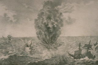 A column of steam and ash rises above the sea surface during the early phase of a submarine eruption in 1831 at Graham Island (Giulia Ferdinandeo) south of Sicily. Earthquakes were first reported on June 28. During the first few days, floating matter, boiling water, and dead fish were observed. On July 8 black smoke was ejected, and by the 12th pumice washed up on the shores of Sicily. A new, but short-lived island was first seen on July 16.
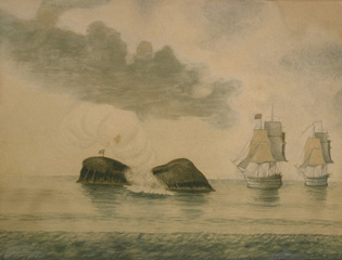 Campi Flegrei del Mar di Sicilia (Phlegraean Fields of the Sicily Sea) is a group of submarine volcanoes off the coast of Sicily. Submarine banks rise from a 1000-m-deep depression between Sicily and Tunisia to near sea level. Submarine eruptions have been recorded since the 3rd century BCE, including some that built ephemeral islands, such as this one at Graham Island (Giulia Ferdinandeo), in 1831.
 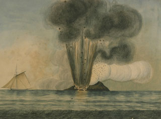 An eruption at Graham Island (Giulia Ferdinandeo) in the Sicilian Sea in 1831. A new island was formed that was promptly claimed by Italy, France, Britain, and Spain. The island quickly eroded to beneath the sea surface after the eruption ended. Graham Island (also known as Ferdinandeo Bank) is part of the Campi Flegrei del Mar di Sicilia (Phlegraean Fields of the Sicily Sea), a group of submarine volcanoes constructed within a depression about 1,000 m deep, SW of Sicily.
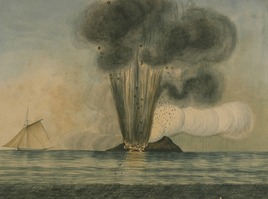
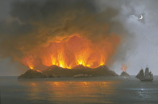 This painting of the eruption of Graham Island (Giulia Ferdinandeo) on 13 July 1831 shows late-stage Strombolian eruptions originating from several vents along a fissure. A submarine eruption that began sometime after 28 June eventually constructed a new island that reached a height of 65 m and a diameter of about 500 m. After August, when the eruption ended, the ephemeral island soon eroded beneath the sea.
The maps shown below have been scanned from the GVP map archives and include the volcano on this page. Clicking on the small images will load the full 300 dpi map. Very small-scale maps (such as world maps) are not included. The maps database originated over 30 years ago, but was only recently updated and connected to our main database. We welcome users to tell us if they see incorrect information or other problems with the maps; please use the Contact GVP link at the bottom of the page to send us email.
There are no samples for Campi Flegrei del Mar di Sicilia in the Smithsonian's NMNH Department of Mineral Sciences Rock and Ore collection.
| Copernicus Browser | The Copernicus Browser replaced the Sentinel Hub Playground browser in 2023, to provide access to Earth observation archives from the Copernicus Data Space Ecosystem, the main distribution platform for data from the EU Copernicus missions. |
| MIROVA | Middle InfraRed Observation of Volcanic Activity (MIROVA) is a near real time volcanic hot-spot detection system based on the analysis of MODIS (Moderate Resolution Imaging Spectroradiometer) data. In particular, MIROVA uses the Middle InfraRed Radiation (MIR), measured over target volcanoes, in order to detect, locate and measure the heat radiation sourced from volcanic activity. |
| MODVOLC Thermal Alerts | Using infrared satellite Moderate Resolution Imaging Spectroradiometer (MODIS) data, scientists at the Hawai'i Institute of Geophysics and Planetology, University of Hawai'i, developed an automated system called MODVOLC to map thermal hot-spots in near real time. For each MODIS image, the algorithm automatically scans each 1 km pixel within it to check for high-temperature hot-spots. When one is found the date, time, location, and intensity are recorded. MODIS looks at every square km of the Earth every 48 hours, once during the day and once during the night, and the presence of two MODIS sensors in space allows at least four hot-spot observations every two days. Each day updated global maps are compiled to display the locations of all hot spots detected in the previous 24 hours. There is a drop-down list with volcano names which allow users to 'zoom-in' and examine the distribution of hot-spots at a variety of spatial scales. |
|
WOVOdat
Single Volcano View Temporal Evolution of Unrest Side by Side Volcanoes |
WOVOdat is a database of volcanic unrest; instrumentally and visually recorded changes in seismicity, ground deformation, gas emission, and other parameters from their normal baselines. It is sponsored by the World Organization of Volcano Observatories (WOVO) and presently hosted at the Earth Observatory of Singapore.
GVMID Data on Volcano Monitoring Infrastructure The Global Volcano Monitoring Infrastructure Database GVMID, is aimed at documenting and improving capabilities of volcano monitoring from the ground and space. GVMID should provide a snapshot and baseline view of the techniques and instrumentation that are in place at various volcanoes, which can be use by volcano observatories as reference to setup new monitoring system or improving networks at a specific volcano. These data will allow identification of what monitoring gaps exist, which can be then targeted by remote sensing infrastructure and future instrument deployments. |
| Volcanic Hazard Maps | The IAVCEI Commission on Volcanic Hazards and Risk has a Volcanic Hazard Maps database designed to serve as a resource for hazard mappers (or other interested parties) to explore how common issues in hazard map development have been addressed at different volcanoes, in different countries, for different hazards, and for different intended audiences. In addition to the comprehensive, searchable Volcanic Hazard Maps Database, this website contains information about diversity of volcanic hazard maps, illustrated using examples from the database. This site is for educational purposes related to volcanic hazard maps. Hazard maps found on this website should not be used for emergency purposes. For the most recent, official hazard map for a particular volcano, please seek out the proper institutional authorities on the matter. |
| IRIS seismic stations/networks | Incorporated Research Institutions for Seismology (IRIS) Data Services map showing the location of seismic stations from all available networks (permanent or temporary) within a radius of 0.18° (about 20 km at mid-latitudes) from the given location of Campi Flegrei del Mar di Sicilia. Users can customize a variety of filters and options in the left panel. Note that if there are no stations are known the map will default to show the entire world with a "No data matched request" error notice. |
| UNAVCO GPS/GNSS stations | Geodetic Data Services map from UNAVCO showing the location of GPS/GNSS stations from all available networks (permanent or temporary) within a radius of 20 km from the given location of Campi Flegrei del Mar di Sicilia. Users can customize the data search based on station or network names, location, and time window. Requires Adobe Flash Player. |
| DECADE Data | The DECADE portal, still in the developmental stage, serves as an example of the proposed interoperability between The Smithsonian Institution's Global Volcanism Program, the Mapping Gas Emissions (MaGa) Database, and the EarthChem Geochemical Portal. The Deep Earth Carbon Degassing (DECADE) initiative seeks to use new and established technologies to determine accurate global fluxes of volcanic CO2 to the atmosphere, but installing CO2 monitoring networks on 20 of the world's 150 most actively degassing volcanoes. The group uses related laboratory-based studies (direct gas sampling and analysis, melt inclusions) to provide new data for direct degassing of deep earth carbon to the atmosphere. |
| Large Eruptions of Campi Flegrei del Mar di Sicilia | Information about large Quaternary eruptions (VEI >= 4) is cataloged in the Large Magnitude Explosive Volcanic Eruptions (LaMEVE) database of the Volcano Global Risk Identification and Analysis Project (VOGRIPA). |
| EarthChem | EarthChem develops and maintains databases, software, and services that support the preservation, discovery, access and analysis of geochemical data, and facilitate their integration with the broad array of other available earth science parameters. EarthChem is operated by a joint team of disciplinary scientists, data scientists, data managers and information technology developers who are part of the NSF-funded data facility Integrated Earth Data Applications (IEDA). IEDA is a collaborative effort of EarthChem and the Marine Geoscience Data System (MGDS). |

