Eruption in 2009 linked to over 100 m of sea floor collapse
We reported in BGVN 34:07 that New Zealand scientists found evidence during a research cruise in 2009 of a recent large eruption at Rumble III, one of more than 30 big submarine volcanoes on the Kermadec Arc, NE of the Bay of Plenty on the N coast of New Zealand's North Island (figures 3 and 4). A newly available report of the 2009 cruise (Dodge, 2010) noted some new details, including the following: (1) since the last study of Rumble III volcano in 2007, significant volcanic activity had occurred; (2) the bathymetric profile of the seamount had changed since it was last mapped in 2007—the summit of Rumble III had collapsed and was ~100 m deeper, at 310 m, much of the 800-m-wide crater was filled by ash, and much of the W side of the volcano had slid down-slope; (3) volcanic flow deposits were documented in camera tows—lava boulders, hackley flow, truncated lobate or pillows, and talus were common; and (4) there was a massive abundance of ash, in particular draped across substrates in many areas, provided compelling evidence for a large eruption since 2007.
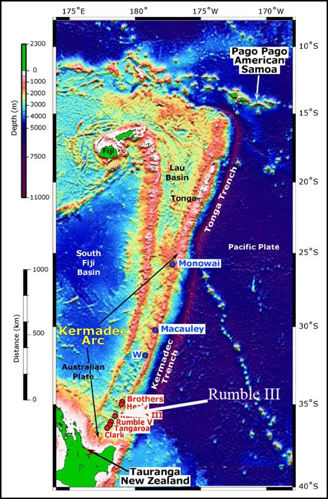 |
Figure 3. Southwest Pacific from Samoa (NE) to New Zealand (SW), showing the location of Rumble III and other submarine volcanoes along the southern Kermadec Arc. Rumble III volcano is located ~ 350 km NE of the Bay of Plenty, New Zealand, 200 km NE of Auckland, and is one of a number of submarine volcanoes that delineate the active arc front in this region. Bathymetry data were satellite-derived (for deep water) and acquired using an EM 300 multibeam echo sounder (along the arc and Lau Basin). Satellite-derived bathymetry from Sandwell and Smith (1997); EM300 bathymetry data courtesy of New Zealand National Institute of Water and Atmospheric Research (NIWA). Map courtesy of National Oceanic and Atmospheric Agency (NOAA) Ocean Explorer web site; from New Zealand American Submarine Ring of Fire 2005 expedition plan. |
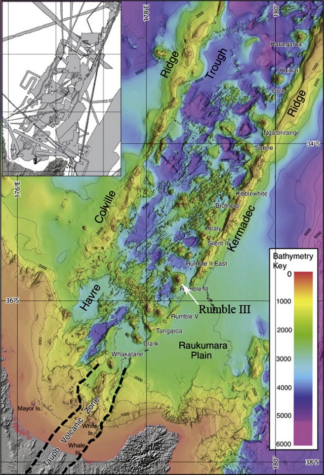 |
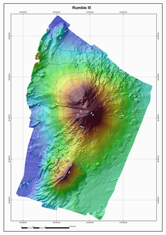
Figure 4. Bathymetric map of all available multibeam data as of 2009 for the Southern Havre Trough, between the Colville and Kermadec Ridges and N of the New Zealand's North Island. In the colored version of this figure, the bathymetry key (in meters) ranges from red at the surface to purple at depths of 5 to 6 km. The location of Rumble III submarine volcano is highlighted. The inset indicates the tracks and areas of individual surveys whose data comprise the map. Areas that are not covered use satellite data configured to fit the edges of multibeam data set. Courtesy of Wysoczanski and others (2010). |
A press release dated 17 August 2010 by the New Zealand National Institute of Water and Atmospheric Research (NIWA) noted that, during an oceanographic cruise aboard NIWA's research vessel R/V Tangaroa in May-June 2010, scientists confirmed that (a) the W flank of the volcano had collapsed ~100 m or more, (b) collapse of 90 m was observed at its highest (shallowest) point, and (c) as much as 120 m collapse occurred in some places. The release noted that the collapse was caused by an eruption some time in the last 2 years.
Glassy, black basaltic rock filled with vesicles was dredged from the volcano. Richard Wysoczanski (NIWA) noted that the samples are the youngest-known rocks from the Kermadec Arc region, created some time between the years 2007 and 2009. It is notable that andesite samples were previously collected from the flank of the submarine volcano by Brothers (1967). Rumble III was last mapped using multibeam technology in 2002.
NIWA principal scientist Geoffrey Lamarche said that the observation of significant pieces of sea floor moving hundreds of meters in height over a short timespan of 8 years give insight into short-time movements of the seabed. Research of the Kermadec Arc is directed in part by NIWA's survey of the area for massive sulphide deposits that sometimes develop over hydrothermal vents.
On 28 February 2011, NIWA and GNS Science announced an upcoming research cruise of about 3 weeks in 2011 to investigate mineral deposits and hydrothermal activity at five major submarine volcanoes in the Kermadec Arc (Clark, Healy, Brothers, Rumble II West, and Rumble III; see figure 4).
References. Brothers, R.N., 1967, Andesite from Rumble III Volcano, Kermadec Ridge, southwest Pacific, Bulletin of Volcanology, v. 31, no. 1, pp. 17-19.
Dodge, E., 2010, Catastrophic volcanic activity at Rumble III volcano based on EM300 bathymetry and direct sea floor imaging, Senior Thesis for Oceanography 444, University of Washington, School of Oceanography, Seattle, WA.
Smith, W. H. F., and Sandwell, D.T., 1997, Global seafloor topography from satellite altimetry and ship depth soundings, Science, v. 277, p. 1957-1962+.
Todd, E., Gill, J.B., Wysoczanski, R.J., Handler, M.R., Wright, I.C., Gamble, J.A., 2010, Sources of constructional cross-chain volcanism in the southern Havre Trough: New insights from HFSE and REE concentration and isotope systematics, Geochemistrry Geophysics Geosystems. v. 11, Q04009, 31 pp, DOI: 10.1029/2009GC002888.
Wysoczanski, R.J., Todd, E., Wright, I.C., Leybourne, M.I., Hergt, J.M., Adam, C., and Mackay, K., 2010, Backarc rifting, constructional volcanism and nascent disorganised spreading in the southern Havre Trough backarc rifts (SW Pacific), Journal of Volcanology and Geothermal Research, v. 190, issues 1-2, p. 39-57.
Information Contacts: Roger Matthews, North Shore City Council, 1 The Strand, Takapuna Private Bag 93500, Takapuna, North Shore City, New Zealand; Richard Wysoczanski, New Zealand National Institute of Water and Atmospheric Research (NIWA) (URL: https://www.niwa.co.nz/); Geoffrey Lamarche, NIWA (URL: https://www.niwa.co.nz/); GNS Science, Wairakei Research Centre, Private Bag 2000, Taupo 3352, New Zealand (URL: http://www.gns.cri.nz/); National Oceanic and Atmospheric Agency (NOAA) Ocean Explorer (URL: http://oceanexplorer.noaa.gov/gallery/gallery.html).
The Global Volcanism Program has no Weekly Reports available for Rumble III.
Reports are organized chronologically and indexed below by Month/Year (Publication Volume:Number), and include a one-line summary. Click on the index link or scroll down to read the reports.
Submarine activity discolors water; hydrophone noise
The New Zealand Defence Scientific Establishment reported that hydrophones detected noise of probable volcanic origin, peaking on 15-16 June. About 1 July, hydrophones on Great Barrier Island, ~290 km SW of Rumble III, recorded noise of possible volcanic origin, but detected no activity by 13 July.
On 13-14 July, a Japanese fishing boat reported cream-colored steam rising from the ocean at 35.74°S, 178.49°E, and observed a 500 m2 sulfur slick. No explosions were reported. The New Zealand Meteorological office reported a satellite-derived sea surface temperature anomaly of possibly +2°C in the area 10-14 July.
On an overflight 5 August, Royal New Zealand Air Force observers saw a circular patch of discolored blue water ~40 m across, thought to be a zone of gas-rich water. The discolored water repeatedly vanished and reformed, then dispersed 4-6 km SW. Sonar buoys dropped into the area detected bubbling noises, but no low-frequency or pulsing noises.
Personnel on the HMNZS Tui examined the area of the volcano during the night or 7-8 August between 2300 and 0500. The sea was calm with no discoloration, sulfur smell, or steam. They found a minimum depth of 150 m [but see 15:03], and samples were dredged from ~300 m.
Information Contacts: J. Latter, DSIR Geophysics, Wellington; L. Hall, Defence Scientific Establishment, Auckland.
Submarine summit bathymetry; bubble plumes in water column
The following observations, made by scientists from the USSR and New Zealand during a cruise of the RV Vulkanolog, were reported by W.F. Giggenbach and I. Menyailov.
"Considerable uncertainty remains about the minimum depth to the summit of Rumble III seamount. Early bathymetric measurements place it at 117 m depth (Kibblewhite and Denham, 1967), while later data and surveys by the RV Vulkanolog in March 1988 suggest a depth of 200 m. A special effort was therefore made to locate its highest point and to determine its depth.
"From echograms, it appears that the uncertainty may largely be due to the production of gas-rich, probably volcanic fluids from the summit area (Kibblewhite, 1966). Close inspection of the echograms shows that reflections above 200 m are probably caused by a plume of expanding bubbles, as they are invariably Separated from the solid reflector (the true summit) by a non-reflecting zone. There, the bubbles are either too small or the prevailing pressures keep the gases in solution.
"In contrast to March 1988, when echograms suggested that some of the bubble swarms reached the surface and gas bubbles were observed from the RV Vulkanolog, in January 1990 the plumes terminated at 150-120 m depth and no bubbles were observed at the surface. The disappearance of bubbles at depths <120 m is likely to be due to re-dissolution of soluble, probably volcanic gases (CO2 and SO2). The decrease in extent of the bubble zones may reflect a decrease in the production rate of thermal fluids and, therefore, of volcanic activity. There were no obvious signs of volcanic activity in either March 1988 or January 1990.
"Several large samples of ferro-magnesian, basaltic pillow lavas were dredged from the slopes of the seamount at depths of 400-1,200 m."
References. Kibblewhite, A.C., 1966, The acoustic detection and location of an underwater volcano: New Zealand Journal of Science, v. 9, p. 178-199.
Kibblewhite, A.C. and Denham, R.N., 1967, The Bathymetry and total magnetic field of the south Kermadec Ridge seamounts: New Zealand Journal of Science, v. 10, p. 52-69.
Information Contacts: I. Menyailov and A. Ivanenko, IV, Petropavlovsk; W. Giggenbach, DSIR Chemistry, Petone.
Gas bubbles detected; summit 140 m below surface
Three previously unknown submarine arc stratovolcanoes have been identified at the S end of the Kermadec Ridge: Rumble V (36.140°S, 178.195°E, summit 700 m below sea level); Tangaroa (36.318°S, 178.031°E, summit 1,350 m below sea level); and Clark (36.423°S, 177.845°E, summit 1,150 m below sea level) (figure 1). All three have basal diameters of 16-18 km and rise from the seafloor at ~2,300 m depth. The first evidence of the volcanoes was from GLORIA side-scan mapping of the southern Havre Trough-Kermadec Ridge region in 1988 (Wright, 1990). Later investigations, including a photographic and rock-dredge study during the 3-week Rapuhia cruise (early 1992), confirmed previous interpretations. Side-scan and photographic data show a complex terrain of lava flows and talus fans on the flanks of all three volcanoes, with the most pristine-looking morphology at Rumble V. During the 1992 cruise, gas bubbles were detected acoustically, rising from the crests of Rumble III, IV, and V. No gas bubbling was evident from Tangaroa or Clark. Bathymetric surveys indicated that the summits of the shallowest volcanoes, Rumble III and IV, were at ~140 and 450 m, respectively, below the sea surface.
 |
Figure 1. Sketch map of New Zealand's North Island and the southern Kermadec Ridge area, with locations of young volcanoes. Courtesy of Ian Wright. |
Reference. Wright, I.C., 1990, Bay of Plenty-Southern Havre Trough physiography, 1:400,000: New Zealand Oceanographic Institute Chart, Miscellaneous Series no. 68.
Information Contacts: I. Wright, New Zealand Oceanographic Institute, National Institute of Water and Atmospheric Research, Wellington.
Submarine summit craters underwent collapse and eruption
GNS Science in New Zealand issued a press release on 12 March 2009 reporting that scientists have returned from exploring submarine volcanoes in the Kermadec arc, where they found evidence of a recent large eruption at Rumble III (figure 2). While mapping the volcano aboard the University of Washington research vessel Thomas G. Thompson on 11 March 2009, they found that marked changes had occurred in the bathymetry of the summits and ash deposits there since their previous visit in 2007. The base of the volcano sits at a depth of 1.4 km.
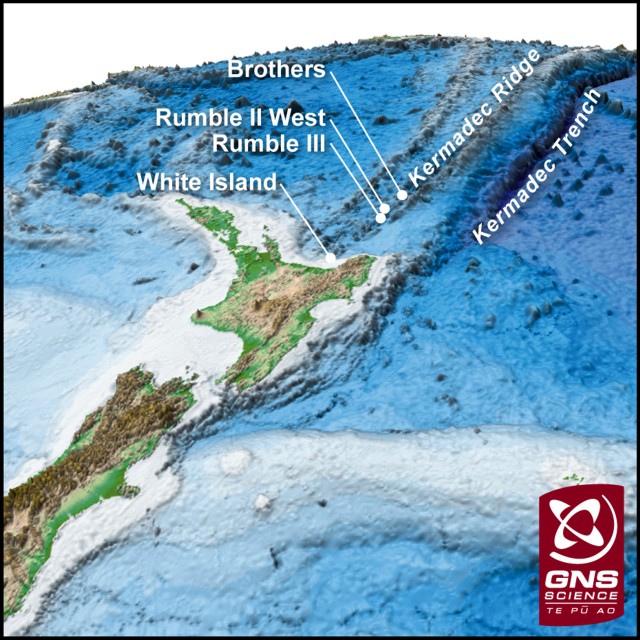 |
Figure 2. Map showing the location of Rumble III and other submarine volcanoes along the southern Kermadec arc. Rumble III volcano is located ~ 350 km NE of the Bay of Plenty, New Zealand, and is one of a number of submarine volcanoes that delineate the active arc front in this region. Courtesy of GNS Science (12 March 2009 press release). |
A 2007 bathymetric map prepared by GNS Science showed an 800-m-wide crater near the top of Rumble III. The map, made aboard the RV Thompson in 2009, showed that this crater has been in-filled and a nearby summit cone had been reduced in height by ~ 100 m. "This suggests there has been a major eruption that collapsed the summit cone and filled the adjacent crater," said Co-Chief Scientist on the voyage, Cornel de Ronde of GNS Science. He also stated that the date of collapse was not known.
According to the same report, images taken by a WHOI underwater camera towed by the research ship showed strewn lava boulders covered by black volcanic ash near the summit. Consistent with the lowering of the summit, de Ronde noted that hydrothermal plumes emanating from the summit vents were more vigorous than observed previously. In addition, some new and deeper vents were discovered.
Olivier Hyvernaud looked for acoustic (T-wave) signals recorded by the French Polynesian network that may have originated from Rumble III. He reported that the Laboratoire de Géophysique in Tahiti did not see any acoustic events from that location.
Information Contacts: GNS Science, Wairakei Research Centre, Private Bag 2000, Taupo 3352, New Zealand (URL: http://www.gns.cri.nz/); Cornel de Ronde, GNS Science (URL: http://www.gns.cri.nz/); Olivier Hyvernaud, Laboratoire de Géophysique, Commissariat a l'Energie Atomique (CEA/DASE/LDG), PO Box 640, Papeete, Tahiti, French Polynesia.
Eruption in 2009 linked to over 100 m of sea floor collapse
We reported in BGVN 34:07 that New Zealand scientists found evidence during a research cruise in 2009 of a recent large eruption at Rumble III, one of more than 30 big submarine volcanoes on the Kermadec Arc, NE of the Bay of Plenty on the N coast of New Zealand's North Island (figures 3 and 4). A newly available report of the 2009 cruise (Dodge, 2010) noted some new details, including the following: (1) since the last study of Rumble III volcano in 2007, significant volcanic activity had occurred; (2) the bathymetric profile of the seamount had changed since it was last mapped in 2007—the summit of Rumble III had collapsed and was ~100 m deeper, at 310 m, much of the 800-m-wide crater was filled by ash, and much of the W side of the volcano had slid down-slope; (3) volcanic flow deposits were documented in camera tows—lava boulders, hackley flow, truncated lobate or pillows, and talus were common; and (4) there was a massive abundance of ash, in particular draped across substrates in many areas, provided compelling evidence for a large eruption since 2007.
|
Figure 3. Southwest Pacific from Samoa (NE) to New Zealand (SW), showing the location of Rumble III and other submarine volcanoes along the southern Kermadec Arc. Rumble III volcano is located ~ 350 km NE of the Bay of Plenty, New Zealand, 200 km NE of Auckland, and is one of a number of submarine volcanoes that delineate the active arc front in this region. Bathymetry data were satellite-derived (for deep water) and acquired using an EM 300 multibeam echo sounder (along the arc and Lau Basin). Satellite-derived bathymetry from Sandwell and Smith (1997); EM300 bathymetry data courtesy of New Zealand National Institute of Water and Atmospheric Research (NIWA). Map courtesy of National Oceanic and Atmospheric Agency (NOAA) Ocean Explorer web site; from New Zealand American Submarine Ring of Fire 2005 expedition plan. |
|
Figure 4. Bathymetric map of all available multibeam data as of 2009 for the Southern Havre Trough, between the Colville and Kermadec Ridges and N of the New Zealand's North Island. In the colored version of this figure, the bathymetry key (in meters) ranges from red at the surface to purple at depths of 5 to 6 km. The location of Rumble III submarine volcano is highlighted. The inset indicates the tracks and areas of individual surveys whose data comprise the map. Areas that are not covered use satellite data configured to fit the edges of multibeam data set. Courtesy of Wysoczanski and others (2010). |
A press release dated 17 August 2010 by the New Zealand National Institute of Water and Atmospheric Research (NIWA) noted that, during an oceanographic cruise aboard NIWA's research vessel R/V Tangaroa in May-June 2010, scientists confirmed that (a) the W flank of the volcano had collapsed ~100 m or more, (b) collapse of 90 m was observed at its highest (shallowest) point, and (c) as much as 120 m collapse occurred in some places. The release noted that the collapse was caused by an eruption some time in the last 2 years.
Glassy, black basaltic rock filled with vesicles was dredged from the volcano. Richard Wysoczanski (NIWA) noted that the samples are the youngest-known rocks from the Kermadec Arc region, created some time between the years 2007 and 2009. It is notable that andesite samples were previously collected from the flank of the submarine volcano by Brothers (1967). Rumble III was last mapped using multibeam technology in 2002.
NIWA principal scientist Geoffrey Lamarche said that the observation of significant pieces of sea floor moving hundreds of meters in height over a short timespan of 8 years give insight into short-time movements of the seabed. Research of the Kermadec Arc is directed in part by NIWA's survey of the area for massive sulphide deposits that sometimes develop over hydrothermal vents.
On 28 February 2011, NIWA and GNS Science announced an upcoming research cruise of about 3 weeks in 2011 to investigate mineral deposits and hydrothermal activity at five major submarine volcanoes in the Kermadec Arc (Clark, Healy, Brothers, Rumble II West, and Rumble III; see figure 4).
References. Brothers, R.N., 1967, Andesite from Rumble III Volcano, Kermadec Ridge, southwest Pacific, Bulletin of Volcanology, v. 31, no. 1, pp. 17-19.
Dodge, E., 2010, Catastrophic volcanic activity at Rumble III volcano based on EM300 bathymetry and direct sea floor imaging, Senior Thesis for Oceanography 444, University of Washington, School of Oceanography, Seattle, WA.
Smith, W. H. F., and Sandwell, D.T., 1997, Global seafloor topography from satellite altimetry and ship depth soundings, Science, v. 277, p. 1957-1962+.
Todd, E., Gill, J.B., Wysoczanski, R.J., Handler, M.R., Wright, I.C., Gamble, J.A., 2010, Sources of constructional cross-chain volcanism in the southern Havre Trough: New insights from HFSE and REE concentration and isotope systematics, Geochemistrry Geophysics Geosystems. v. 11, Q04009, 31 pp, DOI: 10.1029/2009GC002888.
Wysoczanski, R.J., Todd, E., Wright, I.C., Leybourne, M.I., Hergt, J.M., Adam, C., and Mackay, K., 2010, Backarc rifting, constructional volcanism and nascent disorganised spreading in the southern Havre Trough backarc rifts (SW Pacific), Journal of Volcanology and Geothermal Research, v. 190, issues 1-2, p. 39-57.
Information Contacts: Roger Matthews, North Shore City Council, 1 The Strand, Takapuna Private Bag 93500, Takapuna, North Shore City, New Zealand; Richard Wysoczanski, New Zealand National Institute of Water and Atmospheric Research (NIWA) (URL: https://www.niwa.co.nz/); Geoffrey Lamarche, NIWA (URL: https://www.niwa.co.nz/); GNS Science, Wairakei Research Centre, Private Bag 2000, Taupo 3352, New Zealand (URL: http://www.gns.cri.nz/); National Oceanic and Atmospheric Agency (NOAA) Ocean Explorer (URL: http://oceanexplorer.noaa.gov/gallery/gallery.html).
|
|
||||||||||||||||||||||||||
There is data available for 6 confirmed eruptive periods.
2008 Jul 2 ± 1 years ± 182 days Confirmed Eruption (Explosive / Effusive) VEI: 0
| Episode 1 | Eruption (Explosive / Effusive) | |||||||||||||||||||
|---|---|---|---|---|---|---|---|---|---|---|---|---|---|---|---|---|---|---|---|
| 2008 Jul 2 ± 1 years ± 182 days - Unknown | Evidence from Observations: Reported | ||||||||||||||||||
|
List of 2 Events for Episode 1
|
|||||||||||||||||||
1986 Jun 15 - 1986 Aug 5 (?) Confirmed Eruption (Explosive / Effusive) VEI: 0
| Episode 1 | Eruption (Explosive / Effusive) | ||||||||||||||
|---|---|---|---|---|---|---|---|---|---|---|---|---|---|---|
| 1986 Jun 15 - 1986 Aug 5 (?) | Evidence from Observations: Hydrophonic | |||||||||||||
|
List of 1 Events for Episode 1
|
||||||||||||||
1973 Oct 15 - 1973 Oct 17 Confirmed Eruption (Explosive / Effusive) VEI: 0
| Episode 1 | Eruption (Explosive / Effusive) | ||||||||||||||
|---|---|---|---|---|---|---|---|---|---|---|---|---|---|---|
| 1973 Oct 15 - 1973 Oct 17 | Evidence from Observations: Hydrophonic | |||||||||||||
|
List of 1 Events for Episode 1
|
||||||||||||||
1970 Jul 2 ± 182 days Confirmed Eruption (Explosive / Effusive) VEI: 0
| Episode 1 | Eruption (Explosive / Effusive) | ||||||||||||||
|---|---|---|---|---|---|---|---|---|---|---|---|---|---|---|
| 1970 Jul 2 ± 182 days - Unknown | Evidence from Observations: Hydrophonic | |||||||||||||
|
List of 1 Events for Episode 1
|
||||||||||||||
1963 Jan 16 ± 15 days - 1966 Dec 16 (on or after) ± 15 days Confirmed Eruption (Explosive / Effusive) VEI: 0
| Episode 1 | Eruption (Explosive / Effusive) | ||||||||||||||
|---|---|---|---|---|---|---|---|---|---|---|---|---|---|---|
| 1963 Jan 16 ± 15 days - 1966 Dec 16 (on or after) ± 15 days | Evidence from Observations: Hydrophonic | |||||||||||||
|
List of 1 Events for Episode 1
|
||||||||||||||
1958 Jul 9 - 1962 Jul 2 ± 182 days Confirmed Eruption (Explosive / Effusive) VEI: 0
| Episode 1 | Eruption (Explosive / Effusive) | ||||||||||||||
|---|---|---|---|---|---|---|---|---|---|---|---|---|---|---|
| 1958 Jul 9 - 1962 Jul 2 ± 182 days | Evidence from Observations: Hydrophonic | |||||||||||||
|
List of 1 Events for Episode 1
|
||||||||||||||
This compilation of synonyms and subsidiary features may not be comprehensive. Features are organized into four major categories: Cones, Craters, Domes, and Thermal Features. Synonyms of features appear indented below the primary name. In some cases additional feature type, elevation, or location details are provided.
Cones |
||||
| Feature Name | Feature Type | Elevation | Latitude | Longitude |
| Lillie | Cone | -1280 m | 35° 51' 13.00" S | 178° 26' 13.00" E |
There are no samples for Rumble III in the Smithsonian's NMNH Department of Mineral Sciences Rock and Ore collection.
| Copernicus Browser | The Copernicus Browser replaced the Sentinel Hub Playground browser in 2023, to provide access to Earth observation archives from the Copernicus Data Space Ecosystem, the main distribution platform for data from the EU Copernicus missions. |
| MIROVA | Middle InfraRed Observation of Volcanic Activity (MIROVA) is a near real time volcanic hot-spot detection system based on the analysis of MODIS (Moderate Resolution Imaging Spectroradiometer) data. In particular, MIROVA uses the Middle InfraRed Radiation (MIR), measured over target volcanoes, in order to detect, locate and measure the heat radiation sourced from volcanic activity. |
| MODVOLC Thermal Alerts | Using infrared satellite Moderate Resolution Imaging Spectroradiometer (MODIS) data, scientists at the Hawai'i Institute of Geophysics and Planetology, University of Hawai'i, developed an automated system called MODVOLC to map thermal hot-spots in near real time. For each MODIS image, the algorithm automatically scans each 1 km pixel within it to check for high-temperature hot-spots. When one is found the date, time, location, and intensity are recorded. MODIS looks at every square km of the Earth every 48 hours, once during the day and once during the night, and the presence of two MODIS sensors in space allows at least four hot-spot observations every two days. Each day updated global maps are compiled to display the locations of all hot spots detected in the previous 24 hours. There is a drop-down list with volcano names which allow users to 'zoom-in' and examine the distribution of hot-spots at a variety of spatial scales. |
|
WOVOdat
Single Volcano View Temporal Evolution of Unrest Side by Side Volcanoes |
WOVOdat is a database of volcanic unrest; instrumentally and visually recorded changes in seismicity, ground deformation, gas emission, and other parameters from their normal baselines. It is sponsored by the World Organization of Volcano Observatories (WOVO) and presently hosted at the Earth Observatory of Singapore.
GVMID Data on Volcano Monitoring Infrastructure The Global Volcano Monitoring Infrastructure Database GVMID, is aimed at documenting and improving capabilities of volcano monitoring from the ground and space. GVMID should provide a snapshot and baseline view of the techniques and instrumentation that are in place at various volcanoes, which can be use by volcano observatories as reference to setup new monitoring system or improving networks at a specific volcano. These data will allow identification of what monitoring gaps exist, which can be then targeted by remote sensing infrastructure and future instrument deployments. |
| Volcanic Hazard Maps | The IAVCEI Commission on Volcanic Hazards and Risk has a Volcanic Hazard Maps database designed to serve as a resource for hazard mappers (or other interested parties) to explore how common issues in hazard map development have been addressed at different volcanoes, in different countries, for different hazards, and for different intended audiences. In addition to the comprehensive, searchable Volcanic Hazard Maps Database, this website contains information about diversity of volcanic hazard maps, illustrated using examples from the database. This site is for educational purposes related to volcanic hazard maps. Hazard maps found on this website should not be used for emergency purposes. For the most recent, official hazard map for a particular volcano, please seek out the proper institutional authorities on the matter. |
| IRIS seismic stations/networks | Incorporated Research Institutions for Seismology (IRIS) Data Services map showing the location of seismic stations from all available networks (permanent or temporary) within a radius of 0.18° (about 20 km at mid-latitudes) from the given location of Rumble III. Users can customize a variety of filters and options in the left panel. Note that if there are no stations are known the map will default to show the entire world with a "No data matched request" error notice. |
| UNAVCO GPS/GNSS stations | Geodetic Data Services map from UNAVCO showing the location of GPS/GNSS stations from all available networks (permanent or temporary) within a radius of 20 km from the given location of Rumble III. Users can customize the data search based on station or network names, location, and time window. Requires Adobe Flash Player. |
| DECADE Data | The DECADE portal, still in the developmental stage, serves as an example of the proposed interoperability between The Smithsonian Institution's Global Volcanism Program, the Mapping Gas Emissions (MaGa) Database, and the EarthChem Geochemical Portal. The Deep Earth Carbon Degassing (DECADE) initiative seeks to use new and established technologies to determine accurate global fluxes of volcanic CO2 to the atmosphere, but installing CO2 monitoring networks on 20 of the world's 150 most actively degassing volcanoes. The group uses related laboratory-based studies (direct gas sampling and analysis, melt inclusions) to provide new data for direct degassing of deep earth carbon to the atmosphere. |
| Large Eruptions of Rumble III | Information about large Quaternary eruptions (VEI >= 4) is cataloged in the Large Magnitude Explosive Volcanic Eruptions (LaMEVE) database of the Volcano Global Risk Identification and Analysis Project (VOGRIPA). |
| EarthChem | EarthChem develops and maintains databases, software, and services that support the preservation, discovery, access and analysis of geochemical data, and facilitate their integration with the broad array of other available earth science parameters. EarthChem is operated by a joint team of disciplinary scientists, data scientists, data managers and information technology developers who are part of the NSF-funded data facility Integrated Earth Data Applications (IEDA). IEDA is a collaborative effort of EarthChem and the Marine Geoscience Data System (MGDS). |


 The Rumble III seamount, the largest of the Rumbles group along the South Kermadec Ridge, rises 2,300 m from the sea floor to within about 200 m of the sea surface. Edifice collapse has left a large horseshoe-shaped scar breached to the W. Fresh-looking andesitic rocks have been dredged from its summit and basaltic lava from its flanks. Rumble III has been the source of several submarine eruptions detected by hydrophone signals.