Based on analysis of satellite images, GeoNet reported that a submarine eruption at an Unnamed volcano (GVP volcano number 243030) about 46 km NW of Tonga’s capital Nuku’alofa began on 23 January. Activity was also identified in images from 26, 28, 29, and 31 January, characterized by discolored water, and a volcanic plume on 31 January.
Source: GeoNet
Plumes of discolored water seen in satellite imagery during 23-28 January 2017
Murray Ford, a coastal geomorphologist from New Zealand's Auckland University, reported in a Radio New Zealand story on 1 February 2017 that satellite imagery showed a large plume of discolored water between Tongatapu and the volcanic Hunga Tonga-Hunga Ha'apai islands. The activity seen by Murray was on a Landsat 8 OLI (Operational Land Imager) satellite image acquired on 27 January 2017 (figure 2). which showed a bright area of discolored water above the summit and a broader area of discolored water immediately NW, likely from previous events. According to volcanologist Brad Scott (GNS Science) there are additional satellite images from 23, 26, 28, and 29 January 2017, indicating that the eruption had been ongoing for over a week. His colleagues in Tonga indicated a possible associated steam plume, but cloud cover made observations uncertain.
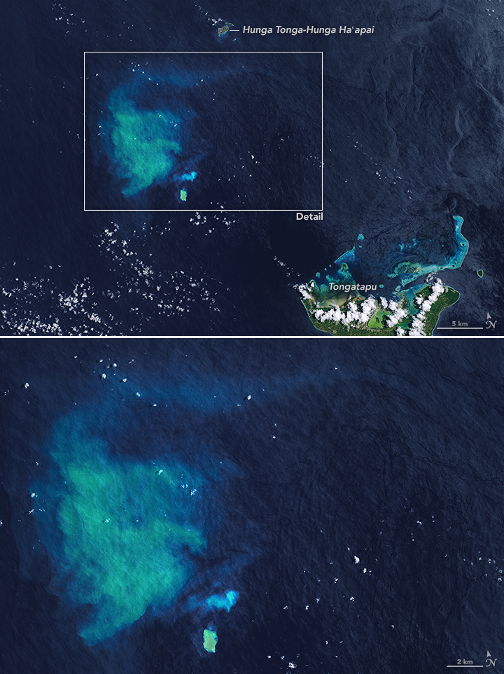 |
Figure 2. Landsat 8 OLI satellite image a submarine plume from an unnamed seamount in Tonga on 27 January 2017, about 33 km NW of Tongatapu island. A small bright area of discolored water is directly over the summit (bottom center), with a small plume immediately N, and a broad area of discolored water to the NW, likely from previous eruptive events. The larger plume to the NW measures 30 km long and 20 km wide. Courtesy of NASA Earth Observatory. |
A report prepared by Taylor (2000) noted that there had been four previous reports of activity from this location: submarine activity in August 1911, a steam plume in July 1923, discolored water in 1970, and an ephemeral island near the end of an eruptive episode during 27 December 1998-14 January 1999 (also see BGVN 24:03). In a blog post about the latest eruption, Brad Scott (GNS Science) also stated that there had been discolored water and felt earthquakes sometime in 2007.
Reference: Taylor, P., 2000, A volcanic hazards assessment following the January 1999 eruption of Submarine Volcano III, Tofua Volcanic Arc, Kingdom of Tonga, Australian Volcanological Investigations (AVI) Occasional Report No. 99/01, 5 August 2000, 7 p.
Information Contacts: NASA Earth Observatory, EOS Project Science Office, NASA Goddard Space Flight Center, Goddard, Maryland, USA (URL: http://earthobservatory.nasa.gov/, https://earthobservatory.nasa.gov/images/89565/underwater-eruption-near-tongatapu); Brad Scott, New Zealand GeoNet Project, a collaboration between the Earthquake Commission and GNS Science, Wairakei Research Centre, Private Bag 2000, Taupo 3352, New Zealand (URL: http://www.geonet.org.nz/, http://www.geonet.org.nz/news/1usjOmF4LqaI64qScMocuW); Radio New Zealand (URL: http://www.radionz.co.nz/international/pacific-news/323569/scientist-discovers-underwater-eruption-in-tonga).
2017: January
Based on analysis of satellite images, GeoNet reported that a submarine eruption at an Unnamed volcano (GVP volcano number 243030) about 46 km NW of Tonga’s capital Nuku’alofa began on 23 January. Activity was also identified in images from 26, 28, 29, and 31 January, characterized by discolored water, and a volcanic plume on 31 January.
Source: GeoNet
Reports are organized chronologically and indexed below by Month/Year (Publication Volume:Number), and include a one-line summary. Click on the index link or scroll down to read the reports.
Large area of water discoloration
Card 0870 (16 February 1970) Large area of water discoloration
William Melson and Robert A. Citron, of the Smithsonian Institution, are on location in the South Pacific . . . . Citron reported the following by cable: "Captain B.N. Rankin, Fiji Airways, spotted submarine volcanic activity on 3 January in vicinity Falcon Island. Rankin estimates discoloration of water covered 500 acre area with a definite division between a patch forming the centre and that surrounding it which was lighter in color. Captain Hillwilliss, Nukualofa, Tonga, believes shoal is Falcon Island. Captain N.M. Ganley, Fiji Airways, gave position of shoal at 35 miles [56 km] SW of . . . Falcon Island."
Information Contacts: Robert A. Citron, Center for Short-Lived Phenomena, Smithsonian Institution.
No activity as of 1974
Admiralty sailing directions (Hydrographer of the Royal Navy, 1984) reported volcanic activity at 20.85°S, 175.55°W in 1970, the site of 1911 and 1923 activity, but noted that in 1974 the volcano was dormant. This entry suggests that the Navy received a report of activity from a passing ship.
Reference. Hydrographer of the Royal Navy, 1984, West approaches - off-lying danger: Pacific Islands Pilot, v. II, British Admiralty Bureau, London, UK, p. 330.
Information Contacts: Hydrographer of the Royal Navy, British Admiralty Bureau, United Kingdom.
Eruption NW of Tongatapu builds temporary island in January
This volcanic center in the Tonga Islands, 35 km NW of Tongatapu (figure 1) and S of Falcon Island, forms part of the Tofua Volcanic Arc (TVA). The following report was compiled from various sources, as well as a submission from Paul Taylor based in part on information obtained from Tongan colleagues.
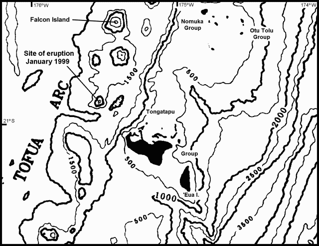 |
Figure 1. Location map of the southern part of the central region of the Tonga Platform and Tofua Volcanic Arc showing the site of the January 1999 volcanic activity in Tonga. Note the NNE-SSW trending trough-like feature that separates the volcanic arc and the Tonga Platform in this region, which may be a southerly extension of the Tofua Trough. Falcon Island is north of the January 1999 eruption site; the structure SSE of Falcon Island contains the islands of Hunga Ha'apai and Hunga Tonga, and was the site of submarine eruptions in 1912, 1937, and 1988. Bathymetric contours are at intervals of 500 m. Courtesy of Paul Taylor. |
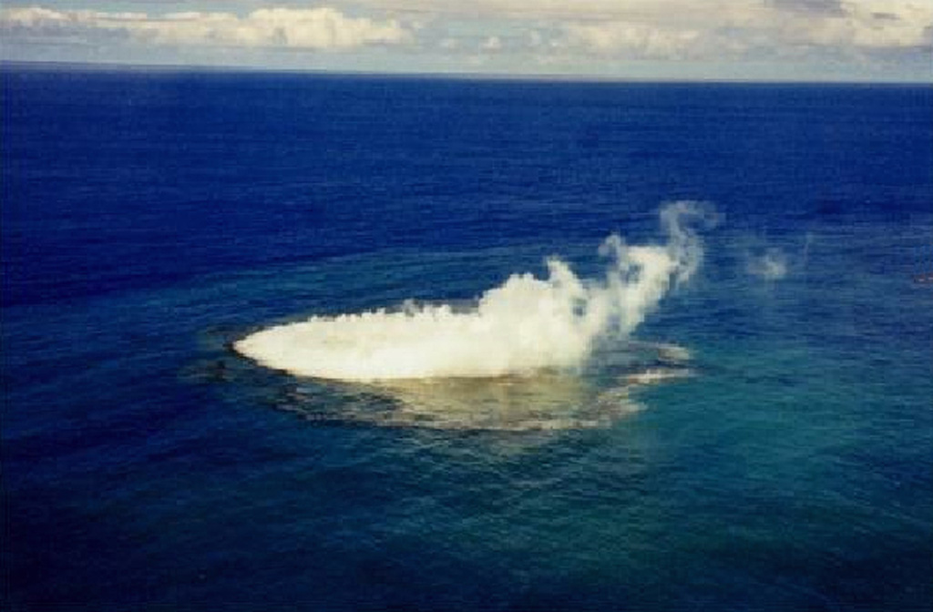
The Tonga Chronicle noted that the activity was first reported to Tonga Defense Services on 8 January by Carl Riechelmann, who had seen a plume coming from the site. On 12 January 1999 the Tonga Defence Services flew a photographic mission to record the reported appearance of a new island. Shortly after departing Tongatapu's Fua'amoto Airport in a Twin Beech equipped for surveillance operations, the crew sighted billowing white plumes from the volcano. The aircraft approached cautiously at 300 m altitude, made one circuit, then descended to 150 m for closer observation. The plane circled for almost an hour while a series of still photographs, as well as a video, were taken. During this time the crew noted that the island appeared to exhibit a pattern of rising, then receding. The island was estimated to be roughly 200-300 m long and 30-40 m wide. The crew also saw lava in a small vent that appeared to be located within a 100-m cone. The island was located at 20° 51.55'S, 175° 32.47'W (20.86°S, 175.54°W). Photographs and a report of their observations were posted on the website of Tonga Cable and Wireless.
Submarine activity continued on 14 January, with turbulent water present around a 40 x 300 m shoal, but no island was observed. Reports described a vent producing an ash-and-steam column and ejecting lava fragments, and floating pumice near the eruption site.
A precautionary Notice to Airmen (NOTAM) was issued to aviators on 14 January by the Nadi Aviation Control Center declaring an area within 5.5 km of the eruption site a danger area. Pilots were requested to report any signs of volcanic activity. Tongan officials also issued a warning to shipping transiting the area.
On 15 January a survey team, including two geologists from the Ministry of Land, Survey, and Natural Resources, inspected the island from the deck of the VOEA Savea, according to a report in the Tonga Chronicle. At that time the island had disappeared beneath the ocean surface, but the site was still emitting smoke and fumes. Because of possible danger, boats were warned to stay away.
Information Contacts: Paul W. Taylor, Australian Volcanological Investigations, PO Box 291, Pymble, NSW 2073, Australia; Kelepi Mafi, Ministry of Lands, Survey, and Natural Resources, P.O. Box 5, Nuku'Alofa, Kingdom of Tonga; Tonga Cable and Wireless, Private Bag 4, Nuku'alofa, Kingdom of Tonga (URL: http://www.candw.to/); Tonga Chronicle, PO Box 197, Nuku'alofa, Kingdom of Tonga; Tom Fox, International Civil Aviation Organization, 999 University Street, Montreal, Quebec H3C 5H7, Canada; Brad Scott, Wairakei Research Centre, Institute of Geological and Nuclear Sciences (IGNS) Limited, Private Bag 2000, Wairakei, New Zealand (URL: https://www.gns.cri.nz/).
Plumes of discolored water seen in satellite imagery during 23-28 January 2017
Murray Ford, a coastal geomorphologist from New Zealand's Auckland University, reported in a Radio New Zealand story on 1 February 2017 that satellite imagery showed a large plume of discolored water between Tongatapu and the volcanic Hunga Tonga-Hunga Ha'apai islands. The activity seen by Murray was on a Landsat 8 OLI (Operational Land Imager) satellite image acquired on 27 January 2017 (figure 2). which showed a bright area of discolored water above the summit and a broader area of discolored water immediately NW, likely from previous events. According to volcanologist Brad Scott (GNS Science) there are additional satellite images from 23, 26, 28, and 29 January 2017, indicating that the eruption had been ongoing for over a week. His colleagues in Tonga indicated a possible associated steam plume, but cloud cover made observations uncertain.
|
Figure 2. Landsat 8 OLI satellite image a submarine plume from an unnamed seamount in Tonga on 27 January 2017, about 33 km NW of Tongatapu island. A small bright area of discolored water is directly over the summit (bottom center), with a small plume immediately N, and a broad area of discolored water to the NW, likely from previous eruptive events. The larger plume to the NW measures 30 km long and 20 km wide. Courtesy of NASA Earth Observatory. |
A report prepared by Taylor (2000) noted that there had been four previous reports of activity from this location: submarine activity in August 1911, a steam plume in July 1923, discolored water in 1970, and an ephemeral island near the end of an eruptive episode during 27 December 1998-14 January 1999 (also see BGVN 24:03). In a blog post about the latest eruption, Brad Scott (GNS Science) also stated that there had been discolored water and felt earthquakes sometime in 2007.
Reference: Taylor, P., 2000, A volcanic hazards assessment following the January 1999 eruption of Submarine Volcano III, Tofua Volcanic Arc, Kingdom of Tonga, Australian Volcanological Investigations (AVI) Occasional Report No. 99/01, 5 August 2000, 7 p.
Information Contacts: NASA Earth Observatory, EOS Project Science Office, NASA Goddard Space Flight Center, Goddard, Maryland, USA (URL: http://earthobservatory.nasa.gov/, https://earthobservatory.nasa.gov/images/89565/underwater-eruption-near-tongatapu); Brad Scott, New Zealand GeoNet Project, a collaboration between the Earthquake Commission and GNS Science, Wairakei Research Centre, Private Bag 2000, Taupo 3352, New Zealand (URL: http://www.geonet.org.nz/, http://www.geonet.org.nz/news/1usjOmF4LqaI64qScMocuW); Radio New Zealand (URL: http://www.radionz.co.nz/international/pacific-news/323569/scientist-discovers-underwater-eruption-in-tonga).
The Global Volcanism Program has no synonyms or subfeatures listed for Unnamed.
|
|
||||||||||||||||||||||||
There is data available for 4 confirmed Holocene eruptive periods.
2017 Jan 23 - 2017 Jan 31 Confirmed Eruption Max VEI: 0
| Episode 1 | Submarine Episode | Submarine | |||||||||||||||||||
|---|---|---|---|---|---|---|---|---|---|---|---|---|---|---|---|---|---|---|---|---|
| 2017 Jan 23 - 2017 Jan 31 | Evidence from Observations: Reported | |||||||||||||||||||
| GeoNet reported that a submarine eruption about 46 km NW of Nuku’alofa began on 23 January 2017. Activity was also identified in satellite images from 26, 28, 29, and 31 January, characterized by discolored water, and a volcanic plume on 31 January. | ||||||||||||||||||||
|
List of 2 Events for Episode 1 at Submarine
| ||||||||||||||||||||
1999 Jan 8 (in or before) - 1999 Jan 14 (?) Confirmed Eruption Max VEI: 1
| Episode 1 | Eruption Episode | ||||||||||||||||||||||||||||||||||||||||
|---|---|---|---|---|---|---|---|---|---|---|---|---|---|---|---|---|---|---|---|---|---|---|---|---|---|---|---|---|---|---|---|---|---|---|---|---|---|---|---|---|
| 1999 Jan 8 (in or before) - 1999 Jan 14 (?) | Evidence from Observations: Reported | |||||||||||||||||||||||||||||||||||||||
| A submarine eruption was first observed on 8 January 1999. On the 12th a new island was reported that was 200-300 m long and 30-40 m wide. Lava was observed in the vent of a small cone on the island. Submarine activity continued on 14 January, with turbulent water present around a shoal, but no island was observed. Reports described a vent producing an ash-and-steam column and ejecting lava fragments, and floating pumice near the eruption site. | ||||||||||||||||||||||||||||||||||||||||
|
List of 6 Events for Episode 1
| ||||||||||||||||||||||||||||||||||||||||
[ 1970 Jan 3 - 1970 Jan 3 ] Uncertain Eruption
| Episode 1 | Uncertain Episode | |||||
|---|---|---|---|---|---|
| 1970 Jan 3 - 1970 Jan 3 | Evidence from Observations: Reported | ||||
| Water discoloration was reported in the area of Falcon Island. There were varying reports as to the location of the event, with one pilot placing it 56 km SW of Falcon Island. The harbormaster of Tonga reported there was no new island, but merely an activated fumarole from an old charted site marked "Volcano 191". | |||||
1923 Jul 1 Confirmed Eruption Max VEI: 0
| Episode 1 | Eruption Episode | |||||||||||||||
|---|---|---|---|---|---|---|---|---|---|---|---|---|---|---|---|
| 1923 Jul 1 - Unknown | Evidence from Observations: Reported | ||||||||||||||
|
List of 1 Events for Episode 1
| |||||||||||||||
1911 Aug Confirmed Eruption Max VEI: 0
| Episode 1 | Eruption Episode | |||||||||||||||
|---|---|---|---|---|---|---|---|---|---|---|---|---|---|---|---|
| 1911 Aug - Unknown | Evidence from Observations: Reported | ||||||||||||||
| Submarine eruption in August 1911 (Sapper, 1927). | |||||||||||||||
|
List of 1 Events for Episode 1
| |||||||||||||||
There is no Deformation History data available for Unnamed.
There is no Emissions History data available for Unnamed.
The maps shown below have been scanned from the GVP map archives and include the volcano on this page. Clicking on the small images will load the full 300 dpi map. Very small-scale maps (such as world maps) are not included. The maps database originated over 30 years ago, but was only recently updated and connected to our main database. We welcome users to tell us if they see incorrect information or other problems with the maps; please use the Contact GVP link at the bottom of the page to send us email.
There are no samples for Unnamed in the Smithsonian's NMNH Department of Mineral Sciences Rock and Ore collection.
| Copernicus Browser | The Copernicus Browser replaced the Sentinel Hub Playground browser in 2023, to provide access to Earth observation archives from the Copernicus Data Space Ecosystem, the main distribution platform for data from the EU Copernicus missions. |
| MIROVA | Middle InfraRed Observation of Volcanic Activity (MIROVA) is a near real time volcanic hot-spot detection system based on the analysis of MODIS (Moderate Resolution Imaging Spectroradiometer) data. In particular, MIROVA uses the Middle InfraRed Radiation (MIR), measured over target volcanoes, in order to detect, locate and measure the heat radiation sourced from volcanic activity. |
| MODVOLC Thermal Alerts | Using infrared satellite Moderate Resolution Imaging Spectroradiometer (MODIS) data, scientists at the Hawai'i Institute of Geophysics and Planetology, University of Hawai'i, developed an automated system called MODVOLC to map thermal hot-spots in near real time. For each MODIS image, the algorithm automatically scans each 1 km pixel within it to check for high-temperature hot-spots. When one is found the date, time, location, and intensity are recorded. MODIS looks at every square km of the Earth every 48 hours, once during the day and once during the night, and the presence of two MODIS sensors in space allows at least four hot-spot observations every two days. Each day updated global maps are compiled to display the locations of all hot spots detected in the previous 24 hours. There is a drop-down list with volcano names which allow users to 'zoom-in' and examine the distribution of hot-spots at a variety of spatial scales. |
|
WOVOdat
Single Volcano View Temporal Evolution of Unrest Side by Side Volcanoes |
WOVOdat is a database of volcanic unrest; instrumentally and visually recorded changes in seismicity, ground deformation, gas emission, and other parameters from their normal baselines. It is sponsored by the World Organization of Volcano Observatories (WOVO) and presently hosted at the Earth Observatory of Singapore.
GVMID Data on Volcano Monitoring Infrastructure The Global Volcano Monitoring Infrastructure Database GVMID, is aimed at documenting and improving capabilities of volcano monitoring from the ground and space. GVMID should provide a snapshot and baseline view of the techniques and instrumentation that are in place at various volcanoes, which can be use by volcano observatories as reference to setup new monitoring system or improving networks at a specific volcano. These data will allow identification of what monitoring gaps exist, which can be then targeted by remote sensing infrastructure and future instrument deployments. |
| Volcanic Hazard Maps | The IAVCEI Commission on Volcanic Hazards and Risk has a Volcanic Hazard Maps database designed to serve as a resource for hazard mappers (or other interested parties) to explore how common issues in hazard map development have been addressed at different volcanoes, in different countries, for different hazards, and for different intended audiences. In addition to the comprehensive, searchable Volcanic Hazard Maps Database, this website contains information about diversity of volcanic hazard maps, illustrated using examples from the database. This site is for educational purposes related to volcanic hazard maps. Hazard maps found on this website should not be used for emergency purposes. For the most recent, official hazard map for a particular volcano, please seek out the proper institutional authorities on the matter. |
| IRIS seismic stations/networks | Incorporated Research Institutions for Seismology (IRIS) Data Services map showing the location of seismic stations from all available networks (permanent or temporary) within a radius of 0.18° (about 20 km at mid-latitudes) from the given location of Unnamed. Users can customize a variety of filters and options in the left panel. Note that if there are no stations are known the map will default to show the entire world with a "No data matched request" error notice. |
| UNAVCO GPS/GNSS stations | Geodetic Data Services map from UNAVCO showing the location of GPS/GNSS stations from all available networks (permanent or temporary) within a radius of 20 km from the given location of Unnamed. Users can customize the data search based on station or network names, location, and time window. Requires Adobe Flash Player. |
| DECADE Data | The DECADE portal, still in the developmental stage, serves as an example of the proposed interoperability between The Smithsonian Institution's Global Volcanism Program, the Mapping Gas Emissions (MaGa) Database, and the EarthChem Geochemical Portal. The Deep Earth Carbon Degassing (DECADE) initiative seeks to use new and established technologies to determine accurate global fluxes of volcanic CO2 to the atmosphere, but installing CO2 monitoring networks on 20 of the world's 150 most actively degassing volcanoes. The group uses related laboratory-based studies (direct gas sampling and analysis, melt inclusions) to provide new data for direct degassing of deep earth carbon to the atmosphere. |
| Large Eruptions of Unnamed | Information about large Quaternary eruptions (VEI >= 4) is cataloged in the Large Magnitude Explosive Volcanic Eruptions (LaMEVE) database of the Volcano Global Risk Identification and Analysis Project (VOGRIPA). |
| EarthChem | EarthChem develops and maintains databases, software, and services that support the preservation, discovery, access and analysis of geochemical data, and facilitate their integration with the broad array of other available earth science parameters. EarthChem is operated by a joint team of disciplinary scientists, data scientists, data managers and information technology developers who are part of the NSF-funded data facility Integrated Earth Data Applications (IEDA). IEDA is a collaborative effort of EarthChem and the Marine Geoscience Data System (MGDS). |


 A plume and discolored water from a submarine eruption were observed in January 1999. This unnamed submarine volcano, 35 km NW of the Niu Aunofo lighthouse on Tongatapu Island, was constructed at the southern end of a submarine ridge segment of the Tofua volcanic arc extending NNE to Falcon Island. The first documented eruptions took place in 1911 and 1923. An ephemeral island was formed during this eruption in 1999; prior to this the summit was 13 m beneath the sea surface.