The Laboratoire de Géophysique reported that explosive volcanic activity may have occurred at Fonualei volcano during late September. On 27, 28, and 30 September numerous short T waves were received by the French Polynesian Seismic Network. The preliminary location of the seismicity was determined to be near the Tonga archipelago at 18.18°S (well constrained) and 174°W (not as well constrained). The hydro-acoustic activity was interpreted to be volcanic and explosive and could not be related to seismic activity at the Tonga Trench. According to the Laboratoire de Géophysique, the hydro-acoustic source could be near Fonualei volcano.
Source: Laboratoire de Géophysique
Typical steam emissions observed in August 2000
In February 1974 a ship's captain reported that Fonualei was "emitting small quantities of steam, foam, and rocks all around the crater" (CSLP Card 1802). Large fluctuations in fumarolic activity were observed by geologists in July 1979 (SEAN 04:12).
On 19 August 2000, Jeff and Raine Williams, aboard the S/Y Gryphon, passed Fonualei enroute from Tonga to Wallis Island. They noted that the lower part of the island was covered with lush tropical vegetation, but the upper parts were scarred brown and gray, and steam was venting from the top of the island. Along the coast were rugged volcanic cliffs and black sand beaches.
[Sections about seismicity and pumice rafts have been moved. Later investigations showed that they probably originated from an unnamed submarine volcano in the Tonga Islands.]
Information Contacts: Jeff and Raine Williams, P.O. Box 729, Funkstown, MD 21734, USA.
2001: October
The Laboratoire de Géophysique reported that explosive volcanic activity may have occurred at Fonualei volcano during late September. On 27, 28, and 30 September numerous short T waves were received by the French Polynesian Seismic Network. The preliminary location of the seismicity was determined to be near the Tonga archipelago at 18.18°S (well constrained) and 174°W (not as well constrained). The hydro-acoustic activity was interpreted to be volcanic and explosive and could not be related to seismic activity at the Tonga Trench. According to the Laboratoire de Géophysique, the hydro-acoustic source could be near Fonualei volcano.
Source: Laboratoire de Géophysique
Reports are organized chronologically and indexed below by Month/Year (Publication Volume:Number), and include a one-line summary. Click on the index link or scroll down to read the reports.
Reported emission of steam, foam, and rocks
Card 1802 (21 February 1974) Reported emission of steam, foam, and rocks
Captain J. Jenkins of the S.S. Union South Pacific reported by radio to Nuku`Alofa, Tonga, the following observation: "Fonualei Island, Tonga, position 18°01' S, 174°19' W (18.02°S, 174.32°W) was emitting small quantities of steam, foam, and rocks all around the crater at 1900 GMT, 15 February 1974."
Tom Simkin indicates that this activity could be a normal geothermal process, but the fact that rocks were being thrown out suggests that the activity is probably significant.
Information Contacts: J. Jenkins, S.S. Union South Pacific, Union Steamship Co. of New Zealand; T. Simkin, Smithsonian Institution.
Steam emissions observed
Geologists aboard the RV Bulikula inspected the volcanoes along the Tonga Arc between 3 and 21 July. . . . Fonualei . . . was emitting steam when viewed . . . in mid-July.
Information Contacts: R. Richmond, Mineral Resources Dept., Fiji.
Fumarolic activity noted during July
Most of the reported eruption sites were investigated during the 11-18 July cruise of the Fijian research vessel RV Bulikula.... Large fluctuations in the intensity of fumarolic activity were observed at both Fonualei and Tofua.
Information Contacts: D. Woodhall and R. Richmond, Mineral Resources Dept., Fiji; D. Tuni, Ministry of Natural Resources, Solomon Islands.
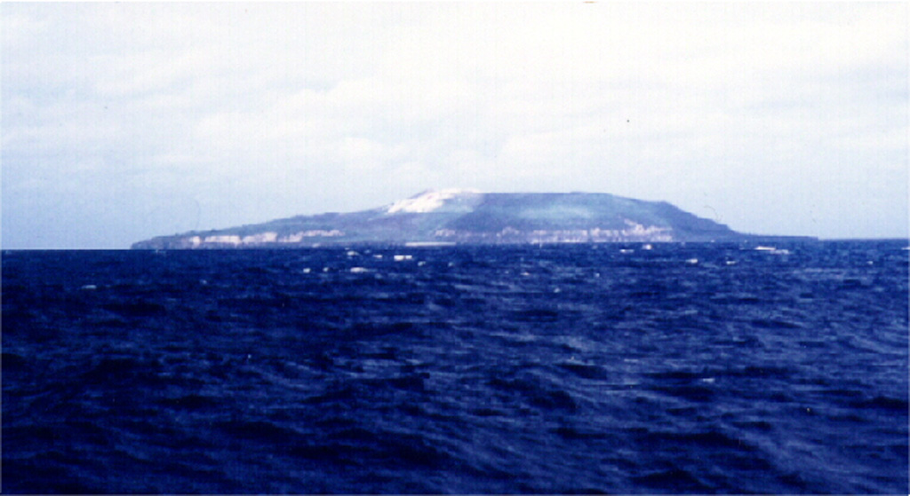
Typical steam emissions observed in August 2000
In February 1974 a ship's captain reported that Fonualei was "emitting small quantities of steam, foam, and rocks all around the crater" (CSLP Card 1802). Large fluctuations in fumarolic activity were observed by geologists in July 1979 (SEAN 04:12).
On 19 August 2000, Jeff and Raine Williams, aboard the S/Y Gryphon, passed Fonualei enroute from Tonga to Wallis Island. They noted that the lower part of the island was covered with lush tropical vegetation, but the upper parts were scarred brown and gray, and steam was venting from the top of the island. Along the coast were rugged volcanic cliffs and black sand beaches.
[Sections about seismicity and pumice rafts have been moved. Later investigations showed that they probably originated from an unnamed submarine volcano in the Tonga Islands.]
Information Contacts: Jeff and Raine Williams, P.O. Box 729, Funkstown, MD 21734, USA.
This compilation of synonyms and subsidiary features may not be comprehensive. Features are organized into four major categories: Cones, Craters, Domes, and Thermal Features. Synonyms of features appear indented below the primary name. In some cases additional feature type, elevation, or location details are provided.
Synonyms |
| Fanua Lai | Amargura | Gardners Island |
|
|
||||||||||||||||||||||||
There is data available for 6 confirmed Holocene eruptive periods.
[ 1974 Feb 16 ] Uncertain Eruption
| Episode 1 | Eruption Episode | ||||||||||||||||||||||||||||||
|---|---|---|---|---|---|---|---|---|---|---|---|---|---|---|---|---|---|---|---|---|---|---|---|---|---|---|---|---|---|---|
| 1974 Feb 16 - Unknown | Evidence from Unknown | |||||||||||||||||||||||||||||
| A Union Steamship Co. of New Zealand ship captain reported the emission of "small quantities of steam, foam, and rocks all around the crater" at 1900 GMT on 15 February 1974 (0800 local time on 16 February) (Smithsonian CSLP Event Card 25-74). | ||||||||||||||||||||||||||||||
|
List of 4 Events for Episode 1
| ||||||||||||||||||||||||||||||
1957 Jun 16 ± 15 days Confirmed Eruption
| Episode 1 | Eruption Episode | |||||
|---|---|---|---|---|---|
| 1957 Jun 16 ± 15 days - Unknown | Evidence from Observations: Reported | ||||
| An eruption was reported by the New Zealand Press Association (Suva, Fiji) on 20 June 1957 (Kear and Wood, 1959). | |||||
1951 Aug 21 Confirmed Eruption Max VEI: 2
| Episode 1 | Eruption Episode | North-central part of the island | ||||||||||||||||||||||||||||||||||
|---|---|---|---|---|---|---|---|---|---|---|---|---|---|---|---|---|---|---|---|---|---|---|---|---|---|---|---|---|---|---|---|---|---|---|---|
| 1951 Aug 21 - Unknown | Evidence from Observations: Reported | ||||||||||||||||||||||||||||||||||
| The Volcano Letter (1951) reported that a Pan American World Airways pilot described an eruption on 21 August 1951 as "...located in the north-central portion of the island, with considerable smoke and a little flame. Large lava flows were evident, some of which were entering the sea. The smoke column rose to about 5,000 feet [1,500 m] and was carried to the northwest by a southeasterly wind." | |||||||||||||||||||||||||||||||||||
|
List of 5 Events for Episode 1 at North-central part of the island
| |||||||||||||||||||||||||||||||||||
1939 Jun Confirmed Eruption Max VEI: 2
| Episode 1 | Eruption Episode | Summit, W and SE sides | ||||||||||||||||||||||||
|---|---|---|---|---|---|---|---|---|---|---|---|---|---|---|---|---|---|---|---|---|---|---|---|---|---|
| 1939 Jun - Unknown | Evidence from Observations: Reported | ||||||||||||||||||||||||
| Eruptions took place from the summit, W side, and SE side. Water spouts were observed ~600 m SE of the island, and five separate eruptions were reported from two different sources. A fresh lava flow that reached the ocean through the breach on the SW side of the crater may have formed during this eruption (Brodie, 1970). | |||||||||||||||||||||||||
|
List of 3 Events for Episode 1 at Summit, W and SE sides
| |||||||||||||||||||||||||
1906 Mar Confirmed Eruption
| Episode 1 | Eruption Episode | |||||
|---|---|---|---|---|---|
| 1906 Mar - Unknown | Evidence from Observations: Reported | ||||
| Fonualei was reported to be in eruption (no details) at the time of an eruption of Ruapehu volcano about 22 March 1906 (Jensen, 1906). | |||||
[ 1847 Jun 1 - 1847 Jul 31 ] Discredited Eruption
Accounts of eruptions in 1846 and 1847 contain similarities and likely refer to the same event. Reports of a major explosive eruption in June or July 1847 (CAVW; Sapper, 1917) that were published in October 1847 in a Honolulu-based newspaper were actually reprints of a March 1847 article in the "Samoan Reporter" of an eruption in June 1846 (Spennemann, 2003).
1846 Jun 11 (?) - 1846 Oct 10 (in or after) Confirmed Eruption Max VEI: 4 (?)
| Episode 1 | Eruption Episode | ||||||||||||||||||||||||||||||||||||||||||||||||||
|---|---|---|---|---|---|---|---|---|---|---|---|---|---|---|---|---|---|---|---|---|---|---|---|---|---|---|---|---|---|---|---|---|---|---|---|---|---|---|---|---|---|---|---|---|---|---|---|---|---|---|
| 1846 Jun 11 (?) - 1846 Oct 10 (in or after) | Evidence from Observations: Reported | |||||||||||||||||||||||||||||||||||||||||||||||||
| Severe earthquakes were felt at Vavau beginning on 9 June 1846. On the night of the 11th bright flashes of light were observed in the direction of Fonualei; the next morning the ground was covered with ash, and crop damage occurred. A ship captain that day reported sailing through an ash cloud dark enough to require use of candles during daylight. Fonualei was also seen in eruption from a passing vessel on 22 June. On 10 October ejections of smoke and stones were seen, with incandescent ejecta at night. Pumice rafts were noted nearby (Sapper, 1917) and ships sailed through ash clouds for about 60 km (Brodie, 1970). CAVW (Richard, 1962) also recorded a lava flow. Following the eruption the population of Toku (13 km SSE) were evacuated to Vavau. | ||||||||||||||||||||||||||||||||||||||||||||||||||
|
List of 8 Events for Episode 1
| ||||||||||||||||||||||||||||||||||||||||||||||||||
1791 Confirmed Eruption Max VEI: 2
| Episode 1 | Eruption Episode | ||||||||||||||||||||
|---|---|---|---|---|---|---|---|---|---|---|---|---|---|---|---|---|---|---|---|---|
| 1791 - Unknown | Evidence from Observations: Reported | |||||||||||||||||||
| Explosive activity reported in 1791 (Richards, 1962, citing Sapper, 1927, and von Wolff, 1929). | ||||||||||||||||||||
|
List of 2 Events for Episode 1
| ||||||||||||||||||||
[ 1780 (in or before) ] Uncertain Eruption
| Episode 1 | Eruption Episode | |||||||||||||||
|---|---|---|---|---|---|---|---|---|---|---|---|---|---|---|---|
| 1780 (in or before) - Unknown | Evidence from Unknown | ||||||||||||||
| When Francisco Antonio Maurelle sighted the island on 26 February 1780 it was reported to be completely barren, suggesting an eruption not long before, perhaps in the 1770s (Spennemann, 2003). The island contains vegetation during non-eruptive periods, and prior to the 1846 eruption inhabitants of Toku Island had gardens on Fonualei. | |||||||||||||||
|
List of 1 Events for Episode 1
| |||||||||||||||
There is no Deformation History data available for Fonualei.
There is no Emissions History data available for Fonualei.
The maps shown below have been scanned from the GVP map archives and include the volcano on this page. Clicking on the small images will load the full 300 dpi map. Very small-scale maps (such as world maps) are not included. The maps database originated over 30 years ago, but was only recently updated and connected to our main database. We welcome users to tell us if they see incorrect information or other problems with the maps; please use the Contact GVP link at the bottom of the page to send us email.
The following 46 samples associated with this volcano can be found in the Smithsonian's NMNH Department of Mineral Sciences collections, and may be availble for research (contact the Rock and Ore Collections Manager). Catalog number links will open a window with more information.
| Catalog Number | Sample Description | Lava Source | Collection Date |
|---|---|---|---|
| NMNH 111548-10 | Dacite | -- | -- |
| NMNH 111548-11 | Volcanic Rock | -- | -- |
| NMNH 111548-12 | Volcanic Rock | -- | -- |
| NMNH 111548-13 | Volcanic Rock | -- | -- |
| NMNH 111548-14 | Pumice | -- | -- |
| NMNH 111548-15 | Volcanic Rock | -- | -- |
| NMNH 111548-16 | Volcanic Rock | -- | -- |
| NMNH 111548-17 | Volcanic Rock | -- | -- |
| NMNH 111548-18 | Volcanic Rock | -- | -- |
| NMNH 111548-2 | Volcanic Rock | -- | -- |
| NMNH 111548-20 | Dacite | -- | -- |
| NMNH 111548-21 | Volcanic Rock | -- | -- |
| NMNH 111548-22 | Volcanic Rock | -- | -- |
| NMNH 111548-24 | Volcanic Rock | -- | -- |
| NMNH 111548-24A | Volcanic Rock | -- | -- |
| NMNH 111548-25 | Volcanic Rock | -- | -- |
| NMNH 111548-26 | Dacite | -- | -- |
| NMNH 111548-27 | Dacite | -- | -- |
| NMNH 111548-28 | Andesite | -- | -- |
| NMNH 111548-29 | Andesite | -- | -- |
| NMNH 111548-3 | Unidentified | -- | -- |
| NMNH 111548-30 | Dacite | -- | -- |
| NMNH 111548-31 | Dacite | -- | -- |
| NMNH 111548-32 | Dacite | -- | -- |
| NMNH 111548-33 | Volcanic Rock | -- | -- |
| NMNH 111548-34 | Volcanic Rock | -- | -- |
| NMNH 111548-35 | Volcanic Rock | -- | -- |
| NMNH 111548-36 | Volcanic Rock | -- | -- |
| NMNH 111548-36A | Andesite | -- | -- |
| NMNH 111548-37 | Dacite | -- | -- |
| NMNH 111548-37A | Andesite | -- | -- |
| NMNH 111548-38 | Pumice | -- | -- |
| NMNH 111548-39 | Volcanic Bomb | -- | -- |
| NMNH 111548-39 | Dacite | -- | -- |
| NMNH 111548-4 | Dacite | -- | -- |
| NMNH 111548-40 | Dacite | -- | -- |
| NMNH 111548-41 | Dacite | -- | -- |
| NMNH 111548-42 | Volcanic Bomb | -- | -- |
| NMNH 111548-43 | Volcanic Bomb | -- | -- |
| NMNH 111548-44 | Volcanic Bomb | -- | -- |
| NMNH 111548-45 | Pumice | -- | -- |
| NMNH 111548-5 | Dacite | -- | -- |
| NMNH 111548-6 | Dacite | -- | -- |
| NMNH 111548-7 | Volcanic Rock | -- | -- |
| NMNH 111548-8 | Dacite | -- | -- |
| NMNH 111548-9 | Volcanic Rock | -- | -- |
| Copernicus Browser | The Copernicus Browser replaced the Sentinel Hub Playground browser in 2023, to provide access to Earth observation archives from the Copernicus Data Space Ecosystem, the main distribution platform for data from the EU Copernicus missions. |
| MIROVA | Middle InfraRed Observation of Volcanic Activity (MIROVA) is a near real time volcanic hot-spot detection system based on the analysis of MODIS (Moderate Resolution Imaging Spectroradiometer) data. In particular, MIROVA uses the Middle InfraRed Radiation (MIR), measured over target volcanoes, in order to detect, locate and measure the heat radiation sourced from volcanic activity. |
| MODVOLC Thermal Alerts | Using infrared satellite Moderate Resolution Imaging Spectroradiometer (MODIS) data, scientists at the Hawai'i Institute of Geophysics and Planetology, University of Hawai'i, developed an automated system called MODVOLC to map thermal hot-spots in near real time. For each MODIS image, the algorithm automatically scans each 1 km pixel within it to check for high-temperature hot-spots. When one is found the date, time, location, and intensity are recorded. MODIS looks at every square km of the Earth every 48 hours, once during the day and once during the night, and the presence of two MODIS sensors in space allows at least four hot-spot observations every two days. Each day updated global maps are compiled to display the locations of all hot spots detected in the previous 24 hours. There is a drop-down list with volcano names which allow users to 'zoom-in' and examine the distribution of hot-spots at a variety of spatial scales. |
|
WOVOdat
Single Volcano View Temporal Evolution of Unrest Side by Side Volcanoes |
WOVOdat is a database of volcanic unrest; instrumentally and visually recorded changes in seismicity, ground deformation, gas emission, and other parameters from their normal baselines. It is sponsored by the World Organization of Volcano Observatories (WOVO) and presently hosted at the Earth Observatory of Singapore.
GVMID Data on Volcano Monitoring Infrastructure The Global Volcano Monitoring Infrastructure Database GVMID, is aimed at documenting and improving capabilities of volcano monitoring from the ground and space. GVMID should provide a snapshot and baseline view of the techniques and instrumentation that are in place at various volcanoes, which can be use by volcano observatories as reference to setup new monitoring system or improving networks at a specific volcano. These data will allow identification of what monitoring gaps exist, which can be then targeted by remote sensing infrastructure and future instrument deployments. |
| Volcanic Hazard Maps | The IAVCEI Commission on Volcanic Hazards and Risk has a Volcanic Hazard Maps database designed to serve as a resource for hazard mappers (or other interested parties) to explore how common issues in hazard map development have been addressed at different volcanoes, in different countries, for different hazards, and for different intended audiences. In addition to the comprehensive, searchable Volcanic Hazard Maps Database, this website contains information about diversity of volcanic hazard maps, illustrated using examples from the database. This site is for educational purposes related to volcanic hazard maps. Hazard maps found on this website should not be used for emergency purposes. For the most recent, official hazard map for a particular volcano, please seek out the proper institutional authorities on the matter. |
| IRIS seismic stations/networks | Incorporated Research Institutions for Seismology (IRIS) Data Services map showing the location of seismic stations from all available networks (permanent or temporary) within a radius of 0.18° (about 20 km at mid-latitudes) from the given location of Fonualei. Users can customize a variety of filters and options in the left panel. Note that if there are no stations are known the map will default to show the entire world with a "No data matched request" error notice. |
| UNAVCO GPS/GNSS stations | Geodetic Data Services map from UNAVCO showing the location of GPS/GNSS stations from all available networks (permanent or temporary) within a radius of 20 km from the given location of Fonualei. Users can customize the data search based on station or network names, location, and time window. Requires Adobe Flash Player. |
| DECADE Data | The DECADE portal, still in the developmental stage, serves as an example of the proposed interoperability between The Smithsonian Institution's Global Volcanism Program, the Mapping Gas Emissions (MaGa) Database, and the EarthChem Geochemical Portal. The Deep Earth Carbon Degassing (DECADE) initiative seeks to use new and established technologies to determine accurate global fluxes of volcanic CO2 to the atmosphere, but installing CO2 monitoring networks on 20 of the world's 150 most actively degassing volcanoes. The group uses related laboratory-based studies (direct gas sampling and analysis, melt inclusions) to provide new data for direct degassing of deep earth carbon to the atmosphere. |
| Large Eruptions of Fonualei | Information about large Quaternary eruptions (VEI >= 4) is cataloged in the Large Magnitude Explosive Volcanic Eruptions (LaMEVE) database of the Volcano Global Risk Identification and Analysis Project (VOGRIPA). |
| EarthChem | EarthChem develops and maintains databases, software, and services that support the preservation, discovery, access and analysis of geochemical data, and facilitate their integration with the broad array of other available earth science parameters. EarthChem is operated by a joint team of disciplinary scientists, data scientists, data managers and information technology developers who are part of the NSF-funded data facility Integrated Earth Data Applications (IEDA). IEDA is a collaborative effort of EarthChem and the Marine Geoscience Data System (MGDS). |


 Seen from the NE, Fonualei volcano is a small, less than 2-km-wide island that contains active fumaroles in the crater, which is breached to the SW with a fresh lava flow extending to the sea and forming a rugged shoreline. Blocky lava flows from a central cone have reached the sea through notches in the caldera rim. Eruptions have been recorded since 1791.