RVO reported that white plumes from Garbuna were emitted during 6-10 October. Deep booming noises were occasionally heard. On 7 October an explosion produced forceful emissions of dense white vapor.
Source: Rabaul Volcano Observatory (RVO)
Occasional ash and steam emissions July to October 2008
Weak to moderate seismicity with an ash emission occurred during March 2008 (BGVN 33:02). According to the Rabaul Volcano Observatory (RVO), white vapor rose from Garbuna during the first 12 days of July; however on 13 July, moderate-to-strong emissions of pale-white to light-gray ash clouds were observed. The ash emissions formed a column that rose ~ 1 km above the summit area. Seismic activity was generally very low during the period.
Additional ash emissions occurred on 5 August, accompanied by incandescent lava ejection, and between 23 September and 1 October. Ash plumes rose ~ 1.6 km and drifted NW. During 1-4 October, forceful emissions of dense white plumes from Garbuna were accompanied by intermittent ash emissions that rose to an altitude of 1.6 km. RVO reported that occasional weak roaring and rumbling noises were heard in Garu village, about 9 km NW.
An overflight on 3 October revealed that existing vents at the summit had increased in size and new vents and fumaroles had appeared in the E sector of the lava dome. The main vent, which had been located on the cone's outside flank, had enlarged considerably (more than tripled in size) and had merged with the November 2005 vent. The original vent that opened on 17 October 2005 was larger and vigorously fuming. There was little evidence of juvenile material having been ejected and surprisingly little eruptive material around the summit; however areas more than 1 km away from the active vents were cratered, possibly from lithic bombs. Fumarolic activity in the summit region away from the currently active vents had ceased.
On 6-10 October the RVO reported that white plumes from Garbuna were emitted and deep booming noises were occasionally heard. On 7 October, an explosion produced forceful emissions of dense white vapor. Seismicity increased to a high level after the explosion. It was characterized by continuous overlapping tremors that continued for a while before declining to a low level again. RVO recorded low-frequency earthquakes on 6 and 8 October. No volcano-tectonic (high-frequency) earthquakes were recorded with those events.
Information Contacts: Herman Patia, Steve Saunders, and Ima Itakarai, Rabaul Volcano Observatory (RVO), PO Box 386, Rabaul, Papua New Guinea.
2008: March
| July
| September
| October
2006: January
2005: October
| November
RVO reported that white plumes from Garbuna were emitted during 6-10 October. Deep booming noises were occasionally heard. On 7 October an explosion produced forceful emissions of dense white vapor.
Source: Rabaul Volcano Observatory (RVO)
RVO reported that forceful emissions of dense white plumes from Garbuna were accompanied by intermittent ash emissions during 1-4 October to an altitude of 1.6 km (5,200 ft) a.s.l. Occasional weak roaring and rumbling noises were reported in Garu village, about 9 km NW. An overflight on 3 October revealed that existing vents at the summit had increased in size and new vents and fumaroles appeared in the E sector of the lava dome. The main vent that had been restricted to the outside flank of the cone had enlarged considerably (more than tripled in size) and merged with the November 2005 vent. The original vent that opened on 17 October 2005 was larger and vigorously fuming. Although there was little evidence of juvenile material having been ejected and there was surprisingly little eruptive material around the summit, it and areas more than 1 km away from the active vents were cratered, possibly from lithic bombs. Fumarolic activity in the summit region away from the currently active vents had ceased.
Source: Rabaul Volcano Observatory (RVO)
RVO reported that ash emissions from Garbuna started on 23 September and continued through 1 October. Ash plumes rose to an approximate altitude of 1.6 km (5,200 ft) a.s.l. and drifted NW.
Source: Rabaul Volcano Observatory (RVO)
Moderate to strong emissions of pale white to light gray ash clouds were observed from Garbuna on the morning of 13 July 2008. Summit activity was low between 1 and 12 July, when emissions consisted mainly of white vapor. The ash emissions on 13 July formed a column that rose about 1 km above the summit area. Seismic activity was generally very low during the corresponding period.
Source: Rabaul Volcano Observatory (RVO)
RVO reported that white plumes from two sources at the summit of Garbuna drifted SE during 19-21 March. Ashfall and a strong sulfur odor were reported in Kimbe Town (about 17 km SE) on 19 March.
Source: Rabaul Volcano Observatory (RVO)
RVO reported that renewed eruptive activity from Garbuna started on 11 March and consisted of ash emissions accompanied by occasional booming noises. The resultant ash plumes rose to an altitude less that 1.6 km (5,200 ft) a.s.l. and drifted SW. Fine ashfall was reported in areas downwind. Ash emissions continued during 12-13 March. During 14-15 March, steam-and-ash plumes again rose to an altitude less that 1.6 km (5,200 ft) a.s.l. and drifted SW. Ashfall and a sulfur odor was reported from areas downwind. Occasional booming noises were heard. On 16 March, steam plumes rose to an altitude of 1.6 km (5,200 ft) a.s.l. Observers from KVO (15 km SE) reported that multiple steam plumes rose from numerous vents at the summit. Steam plumes were again noted on 17 and 18 March and a strong sulfur odor was noticed on 18 March.
Source: Rabaul Volcano Observatory (RVO)
During 1-15 January, the two vents at the summit of Garbuna emitted small-to-moderate volumes of gas. There were no other unusual observations. Seismicity was low and dominated by occasional low-frequency earthquakes.
Source: Rabaul Volcano Observatory (RVO) via the Darwin Volcanic Ash Advisory Center
During 21-27 November, two vents at the summit of Garbuna continued to release weak-to-moderate volumes of steam that rose a few hundred meters above the summit and drifted in various directions. No incandescence was seen at the volcano and no noises were heard. Seismicity was at very low levels.
Source: Rabaul Volcano Observatory (RVO) via the Darwin Volcanic Ash Advisory Center
Based on information from RVO and satellite imagery, the Darwin VAAC reported that on 25 October a pale gray ash cloud rose a few hundred meters above the summit of Garbuna, but no eruption was noted.
Source: Darwin Volcanic Ash Advisory Centre (VAAC)
RVO reported that visually Garbuna remained unchanged on 22 October from it's condition during the previous days, with moderate-to-thick "white fume" billowing from two vents. A banging noise from the summit region was heard on the evening of 21 October in the nearby towns of Walindi and Kimbe. The scent of sulfur was noted in Sisi village. Seismicity increased slightly, but remained at low levels. Small high-frequency events were common. Based on information from RVO, the Darwin VAAC reported that a minor ash cloud emitted from the volcano on 24 October rose a few hundred meters above the summit
Sources: Rabaul Volcano Observatory (RVO); Darwin Volcanic Ash Advisory Centre (VAAC)
RVO reported that an eruption began at Garbuna on the afternoon of 16 October when "white vapor" rose above the volcano and a couple of felt earthquakes occurred. On 17 October, an eruption column rose 3-4 km above the volcano's summit (or 11,700-15,000 ft a.s.l.). At 1100 fine ash fell on the W and NW sides of the volcano, covering two plantations. Water sources originating from Garbuna were affected by the eruption. According to RVO, the volcano last erupted about 1,700 years ago.
Sources: The National; Darwin Volcanic Ash Advisory Centre (VAAC); Rabaul Volcano Observatory (RVO)
Reports are organized chronologically and indexed below by Month/Year (Publication Volume:Number), and include a one-line summary. Click on the index link or scroll down to read the reports.
First historically witnessed eruption in October 2005
This report concerns Garbuna volcano's first historically witnessed eruption. That occurred in mid-October 2005 after a felt earthquake. This report contains a section by members of the Rabaul Volcano Observatory (RVO) and another by Rodger Wilson, a NOAA meteorologist , who made an unofficial visit in November.
Setting. Garbuna is part of the 23 x 15 km Krummel-Garbuna-Welcker complex (a volcanic field with these major topographic highs located in S-to-N progression; figure 1). The field resides at the S end of New Britain island's Willaumez (Talasea) peninsula, a narrow projection jutting well N from the island's W-central region. The peninsula and some local reefs and islands are known for volcanoes and hydrothermal features (including, from N to S, Dakataua caldera and its large lake, Bola stratovolcano, Garua Harbour volcanic field, and the Garbuna complex). In addition to young volcanics found at the complex's three summit (ridge) centers and their associated domes and craters, there have been prior flank and eccentric eruptions, most notably Numundo Maar. The complex's products are mostly high-SiO2 andesites to high-SiO2 dacites with more mafic eruptives from Krummel and Numundo Maar. (McKee and others, 2005). Only 5-6 km to the E and W of the volcanic field are some inhabited and intensively cultivated strips along the coast.
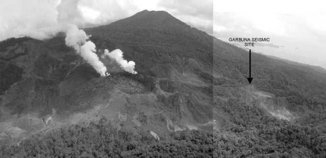 |
Figure 1. Photograph of Garbuna taken on 19 October 2005 from the SSE. View is northward along the Krummel-Garbuna-Welcker ridge, across the general area of Garbuna with Welcker on skyline; Krummel is behind the camera. The two fuming vents can be seen on the periphery of an old lava dome. The bare geothermal nature of the area is apparent. The incised cone to the left is what locals refer to as Mount Garbuna. Photo by Steve Saunders provided courtesy of RVO. |
Garbuna and Welcker volcanoes were thought to have had a latest significant/datable eruption at ~ 1,800 BP. Garbuna in particular was very geothermally active, with the central area containing 4 km2 of fumaroles, solfataras, hot and bubbling mud and water springs, and patches of hot ground. Conspicuous from the barren, sulfurous and geothermally altered, clay-rich areas was a timber-covered but undated lava dome (or alternately, a short, thick lava flow to the S, a feature sometimes described as a coulée). This dome shows little geothermal alteration, appears very youthful, and is not obviously mantled by the regional tephras from Witori or Dakataua, all features suggesting a comparatively young age. The low cone hosting the dome stands ~ 500-600 m in diameter.
Events surrounding the eruption. The RVO team reported this section and noted that the complex was not instrumentally monitored. A single, locally felt earthquake occurred around midday on 16 October 2005. Jet-like noises were noticed about 2342 that night, rumbling noises started soon after, and at about midnight ash emissions began. The eruption continued and by morning pale to dark gray ash clouds were being driven forcefully into the sky. By 1000 a 3-4-km-high eruption column was visible; the main plume drifted NW with a thin veil of falling material below it. The eruption began to wane between midnight and the morning of 18 October, reducing to slow pale-gray emissions, with only white vapor by the end of the day. A second vent opened quietly during the night of the 18-19 October, with two white vapor plumes visible at dawn on the 19th.
Aerial inspections on 19, 20, and 26 October showed the two vents situated in the central low area of Garbuna, historically an area of high geothermal activity. Both vents are located on or close to the edge of the youthful lava dome mentioned above. The center of the dome is at 05° 26' 48" S, 150° 01' 36" E, with the active vents aligned SW-NE at across a NW sector of the old cone. Both active vents are 60-75 m in diameter and emitted low to moderate amounts of white fume, the southerly plume being more voluminous. On the first two visits fume billowed out gently.
The SW vent seems to have been the source of the initial October emissions. Before the 19th a small incomplete cone had formed around it. Within a kilometer of this vent several ten's of centimeters of ash/mud had been deposited, which thinned very rapidly away from the vent. Old records did not indicate the existence of the SW vent or other conspicuous feature prior to the onset of this eruption.
The second, or NE, vent became active on the night of 18-19 October. Photographs from 1996 showed that prior to the eruption this vent was a small, wooded, funnel-shaped pit, with some evidence of instability on its western side and visible un-vegetated scars.
Although ashfall was reported to the NW, images of the eruption at first light on the 17th showed the fallout to resemble rain rather than dry ash. Vegetation damaged by the fallout had brown blotches rather than uniform discoloration, leading to the conclusion that the initial column was made up primarily of acidic water and mud.
It appears that the NE vent is predominantly a collapse feature, surrounded by a small apron of brownish-gray mud, with a jagged edge and bright red/yellow walls. Following a locally felt earthquake, summit observations on the 20th showed that the NE vent had increased ~ 10-20 m by concentric collapse since the previous day and was 50-60 m deeper. At this time it contained a boiling mud lake ~ 60-70 m below the rim.
Observations on the 26th showed the ash cone around the SW vent had all but disappeared as it had increased in size by collapse. The resulting pit was irregular in shape. Quite vigorous steam emissions occurred and some ash was visibly mixed with the fume and dropping out as fine droplets of dilute mud. Impact craters from projectiles were evident around the vent, especially to the SW. Near the vent these small projectiles were visible and block-like. Up to 500-600 m to the SW small impact craters could still be seen but the projectiles themselves were not apparent.
Close study of the old dome, on whose periphery the vents have opened, suggests that it has undergone little or no movement during the onset of this eruption. Foliage-stripped trees are mainly up-right, and no fresh cracks or heaved boulders are evident. Thermal imagery also showed no hot cracks in the dome, suggesting that the eruption was not preceded by intense surface deformation, and that the vents are now enlarging by concentric collapse.
A large area of grass N of the vents gave the impression of having been flattened in a uniform direction. Trees and shrubs, although stripped of leaves, did not show this flattening. This may suggest that floods of water were responsible for the flattened grass, rather than blast effects. To the S, flooding is also suggested by the apparently recent incising of the valley floor (headwaters of the Garu-Haella sulfur stream). The edge of the jungle also shows undercutting with trees having fallen toward the vents.
Since the start of the eruption changes in the amount of discharge, along with unusual discoloration and dying fish were seen in the streams draining from Garbuna. On 26 October, aerial observers followed one of the Garu thermal streams from the Plantation-Garu village road on its ascent to the summit. At higher elevations the stream's water level dropped markedly, until within a few kilometers of the summit, it dried out completely. The stream was not blocked or dammed, and the falling levels of streams and drying of springs appeared to be related to the drying of the summit, or fracturing, allowing water to percolate into the mountain rather than flow off the geothermally produced clay-rich area. At first light on the morning of 29 October, the watercourse commonly known as the Walindi river was milky white with a blue tinge. It was odorless, of normal temperature, and tasted simply of clayey water with no bitterness. This is the first recorded case of one of the eastern drainage systems exhibiting this behavior, although it is common in the W and SW regions.
A few locally felt earthquakes and sulfur odors were reported from areas not traditionally affected by the complex's sulfatara emissions. On several occasions explosions or booming noises from the Garbuna area were heard at Garu Plantation.
Two seismic stations were installed on 18 October. A 3-component digital recorder was located at Garu Plantation ~ 5.5 km SW of the active vents. An analog recorder was installed at Sisi near Walindi, ~ 5.6 km E of the vents. Notable seismicity was recorded on 20, 21, and 22 October. On the 20th a ML ~ 2.5 local volcano-tectonic earthquake was felt, which was followed by a dozen smaller VT earthquakes between 1300 and 1500. Starting about 0500 on 21 October many very small (ML < 0.5) VT earthquakes began to occur. These events continued throughout 21 October and ceased about 1600 on 22 October. Random VT earthquakes numbering 1-4 per day were recorded on 23, 25, and 28 October. Other volcano-related earthquakes recorded included some small low-frequency earthquakes on 22 October by the Sisi station. Continuous tremor was recorded immediately when a new telemetered seismometer was installed about 0.9 km NE of the active vents. At the end of the month the tremors were continuing.
The West New Britain Provincial Disaster Committee has ensured a smooth civic response to this unforeseen event with public education and preparations for a possible evacuation being well advanced.
Observations during mid-November 2005. Rodger Wilson submitted the following report of his visit to Garbuna with John Seach.
"We climbed Garbuna the first time on 14 November. We smelled H2S(?) from at least three locations at lower elevations along the trek. Wind at the time was to the NE, so I don't believe we were sensing the summit gas plume. Also, there was an area that I jokingly referred to as, 'The Valley of Death,' where we all (four) felt nauseated (on both climbs at the same location, both coming and going), but did not detect any odor of gas. On the second climb, we found an immature parrot on the ground at the (SE?) edge of this area (we removed him from that area, and he seemed fine afterward). Again, we were unable to get a GPS fix there, but it occurs along a (NW to SE-running?) depression just prior to a steeper climb to the summit.
"Just before reaching the clearing at the summit, along a more N-S-running depression, we encountered an area where the trees appeared to have been 'sprayed' horizontally as evidenced by ash being 'plastered' to their N (crater) sides. Bark on many of the larger trees appeared to be at least lightly abraded, but not removed. Numerous smaller trees of approximately 6 cm or less in diameter had been neatly 'clipped' or sharply bent over at just less than 2 m height. There was no evidence of high temperature in connection with the physical damage. Our visit was restricted to along the S edge of the summit, bounded by the hydrothermal area on the W and the two old phreatic craters to the E. This area of damaged trees was, as far as we could see, the only significant damage to the surrounding forest (by a base surge or a cold density current?) in contrast to the more complete devastation suffered by the fewer trees and lower vegetation at the summit. Interestingly, the trees still standing at the summit, appeared to be stripped solely by vertically falling, not horizontally moving, debris.
"We exited the forest at the summit at about 1100, along a N-S bare ridge (old crater rim?), that is clearly visible in aerial photos of the area. Copious fume emanated soundlessly from the two new craters. White fume exited the western crater, with yellow-tinged fume rising from the eastern one. There was a fairly strong smell of H2S, but not the eye-stinging or choking sensation I've felt with SO2 at Etna and Stromboli. As we rested there, we noted the water in our bottles was in constant motion and once we made our way to the thermal area, we clearly felt frequent (several per minute) small shocks while we took temperatures at several spots there. The highest temperatures were all at 100°C. During the first couple of hours at the summit, we had two brief bands of rain showers pass overhead, but by about 1330 the rain became sustained and heavy. Run-off in most of the surrounding gullies had increased to several inches deep. We . . . were picking our way back toward the forest when, just as we left the southern edge of the thermal area, we heard a loud roar and witnessed a lahar issue from the gully draining the crater . . ..
"Changes we noted during the second visit 3 days later were [as follows]: a low rumble or rushing noise associated with the summit vents which was heard through most of the journey to the summit, although [they observed] a complete lack of detectable seismicity while at the summit. The interval between "huffs" of fume was shorter, on the order of maybe 4-5 minutes rather than the 8-10 minutes observed during the first visit. Fume leaving the western vent remained white, while ash was clearly visible as it fell over the E flank of the volcano from the eastern plume. That plume also had a more yellow cast as it issued from its source, compared with a few days before.
"We heard low booming rumbles from near Walindi at around 0530 on 17 November and loud roaring the next morning at about 0700 from the same location. The latter was preceded (by as much as 10 minutes) by dogs at our location being agitated and barking, simultaneously with others in the distance.
Reference. McKee, C.O., Patia, H., Kuduon, J., and Torrence, R., 2005, Volcanic Hazard Assessment of the Krummel-Garbuna-Welcker Volcanic Complex, Southern Willaumez Peninsula, WNB, Papua New Guinea: Geological Survey of Papua New Guinea—Report 2005/4.
Information Contacts: Steve Saunders, Ima Itikarai, and Herman Patia, Rabaul Volcano Observatory (RVO), P.O. Box 386, Rabaul, Papua New Guinea; Rodger Wilson, Meteorological Technician, US National Oceanic and Atmospheric Administration (NOAA) and National Weather Service (NWS), WSO, P.O. Box 1685, Valdez, AK 99686, USA.
Steam, small earthquakes, and weak tremor since mid-November 2005
Garbuna volcano's first historically witnessed eruption in October 2005 was reported in BGVN (30:11) and by 14 November the mountain was climbed. Since that time two reports from the Rabaul Volcano Observatory (RVO), one dated 21-27 November 2005 and the other 1-15 January 2006 both noted weak-to-moderate releases of white vapor from the two vents on the summit. Both reports also indicated that there were no noises or glow accompanying the emissions and that seismic activity was low.
The November 2005 report stated that on some days plumes rose vertically a few hundred meters and drifted variably to the NW, W, SW, and occasionally SE. It also noted that the distinct moderate tremor recorded in the previous weeks at the summit ceased by 15 November although weak tremor was recorded on some days, as were small high-frequency earthquakes numbering one to six per day.
RVO's January report described weak to moderate volumes of white vapor released from the two summit vents. The accompanying seismicity was low and dominated by occasional low-frequency earthquakes, as indicated by the two stations located 5-6 km E and SW of the summit.
Information Contacts: Ima Itikarai, Rabaul Volcano Observatory (RVO), P.O. Box 386, Rabaul, Papua New Guinea; Andrew Tupper, Darwin Volcanic Ash Advisory Centre (VAAC), Bureau of Meteorology, Northern Territory Regional Office, PO Box 40050, Casuarina, Northern Territory 0811, Australia (URL: http://www.bom.gov.au/info/vaac/).
Earthquakes continue while vents remain calm through April 2006
Garbuna remained relatively quiet between mid-February and mid-April 2006. The two vents at the summit released weak to moderate volumes of white vapor during this time, but no glow was observed. There was a weak rumbling noise on 14 April. Seismic activity remained at a low level. Few earthquakes were recorded during February and March; the daily average number of high-frequency events was 3 and of low-frequency events between 0 and 5. In April, a few earthquake swarms were recorded with individual events every 1-2 minutes. These episodes lasted less than 20 minutes. Low-frequency earthquakes occurred at the rate of 3-5 times per day and the Real-time Seismic Amplitude Measurement (RSAM) data was at background level fluctuating between 8 and 51 units.
Information Contacts: Ima Itikarai and Herman Patia, Rabaul Volcano Observatory (RVO), P.O. Box 386, Rabaul, Papua New Guinea.
Boiling water in two summit craters, low seismicity
According to the Rabaul Volcanological Observatory (RVO), Garbuna remained quiet from February 2006 through 10 June 2007. Two vents produced the first historically witnessed eruption from this volcano in October 2005 (BGVN 30:11). At least one summit vent continued to release small-to-moderate volumes of white vapor that could be seen from the observation post 15 km SE. There have been no noises heard nor glow observed at night.
An aerial inspection on 2 February 2006 revealed that both summit vents had increased in size and contained vigorously boiling water. The town of Kimbe (-16.6 km SE) experienced continuous rainfall during the days prior to this inspection. A weak smell of sulfur was detected 5 km E of Garbuna on 2 February. Seismic activity was at a low level, between 0 and 9 earthquakes per day, dominated by high-frequency events. Some low-frequency events were also recorded. A faulty seismometer at the summit was replaced and a new global positioning system (GPS) station for monitoring ground deformation was installed on 2 February 2006.
During December 2006 through 10 June 2007, seismicity continued at a low level, dominated by high-frequency volcanic earthquakes (87 in number) recorded daily; none were located due to insufficient seismic stations. Daily totals in December 2006 ranged between 1 and 16 earthquakes, the highest number of events (16) being recorded on 22 December 2006. No low-frequency earthquakes were recorded during December 2006. During January through 10 June 2007 there were 2-3 daily high-frequency events on average, with up to 5 on some days. The summit seismograph picked up continual tremor from the boiling lake in the main vent. Technical problems with the summit seismometer were experienced at times in March, May, and June. Based on GPS measurements, ground deformation showed no significant changes during this period.
Information Contacts: Herman Patia, Steve Saunders, and Felix Taranu, Rabaul Volcano Observatory (RVO), PO Box 3386, Rabaul, E.N.B.P, Papua New Guinea.
Ash emissions during March 2008
Garbuna again began to erupt in March 2008. Prior to that, during late June 2007, the summit continued to release variable volumes of white vapor. Occasional increases in volume caused concern in local communities, although noises and night-time glow were absent. An investigation by the West New Britain Disaster Office indicated no other increased activity or emission of solid material. Vapor emissions from the active vent continued through October 2007. Through the end of 2007 and into January and February 2008 activity was characteristically uneventful, with no indication of an eruption.
A new eruption began on 11 March 2008. Gray ash clouds rose less than a kilometer above the summit before being blown SW, causing fine ashfall. Occasional booming noises were heard accompanying the ash emissions. Ash emissions continued on 12-13 March, and reports indicated most of the ash fell in the summit area. On 14-15 March the odor of sulfur was reported downwind. No glow was visible at night. Around this time, observations from the Kulingai Volcano Observatory (15 km SE) noted white vapor emissions from numerous vents at the summit area. During 17-18 March activity increased slightly with forceful and continuous emission of white vapor. Emissions rose vertically less than a kilometer before dissipating. There were no noises heard and no glow visible at night. A strong smell of sulfur was again noted to the E.
All of the monitoring equipment installed during 2005 and 2006 was destroyed. The two GPS stations at the summit and at the base remained out of service, and for most of the reporting interval there was no functioning seismometer. Seismicity began to be monitored using a KD1 recorder, along with a portable seismometer to the E, at SiSi village. Seismicity fluctuated between low and moderate levels. On 17 March, seismicity increased to a moderate level characterized by non-overlapping tremor. Only three high-frequency volcano-tectonic earthquakes were noted during the first day of recording; no low-frequency events were recorded. Seismicity declined on 18 March but rose to a moderate level on 19 March.
Information Contacts: Herman Patia, Steve Saunders, and Felix Taranu, Rabaul Volcano Observatory (RVO), PO Box 3386, Rabaul, E.N.B.P, Papua New Guinea.
Occasional ash and steam emissions July to October 2008
Weak to moderate seismicity with an ash emission occurred during March 2008 (BGVN 33:02). According to the Rabaul Volcano Observatory (RVO), white vapor rose from Garbuna during the first 12 days of July; however on 13 July, moderate-to-strong emissions of pale-white to light-gray ash clouds were observed. The ash emissions formed a column that rose ~ 1 km above the summit area. Seismic activity was generally very low during the period.
Additional ash emissions occurred on 5 August, accompanied by incandescent lava ejection, and between 23 September and 1 October. Ash plumes rose ~ 1.6 km and drifted NW. During 1-4 October, forceful emissions of dense white plumes from Garbuna were accompanied by intermittent ash emissions that rose to an altitude of 1.6 km. RVO reported that occasional weak roaring and rumbling noises were heard in Garu village, about 9 km NW.
An overflight on 3 October revealed that existing vents at the summit had increased in size and new vents and fumaroles had appeared in the E sector of the lava dome. The main vent, which had been located on the cone's outside flank, had enlarged considerably (more than tripled in size) and had merged with the November 2005 vent. The original vent that opened on 17 October 2005 was larger and vigorously fuming. There was little evidence of juvenile material having been ejected and surprisingly little eruptive material around the summit; however areas more than 1 km away from the active vents were cratered, possibly from lithic bombs. Fumarolic activity in the summit region away from the currently active vents had ceased.
On 6-10 October the RVO reported that white plumes from Garbuna were emitted and deep booming noises were occasionally heard. On 7 October, an explosion produced forceful emissions of dense white vapor. Seismicity increased to a high level after the explosion. It was characterized by continuous overlapping tremors that continued for a while before declining to a low level again. RVO recorded low-frequency earthquakes on 6 and 8 October. No volcano-tectonic (high-frequency) earthquakes were recorded with those events.
Information Contacts: Herman Patia, Steve Saunders, and Ima Itakarai, Rabaul Volcano Observatory (RVO), PO Box 386, Rabaul, Papua New Guinea.
This compilation of synonyms and subsidiary features may not be comprehensive. Features are organized into four major categories: Cones, Craters, Domes, and Thermal Features. Synonyms of features appear indented below the primary name. In some cases additional feature type, elevation, or location details are provided.
Cones |
||||
| Feature Name | Feature Type | Elevation | Latitude | Longitude |
| Garbuna | Stratovolcano | 802 m | 5° 26' 25" S | 150° 1' 31" E |
|
Krummel
Worri |
Stratovolcano | 840 m | 5° 28' 21" S | 150° 1' 46" E |
| Welcker | Stratovolcano | 1064 m | 5° 24' 59" S | 150° 1' 36" E |
Craters |
||||
| Feature Name | Feature Type | Elevation | Latitude | Longitude |
| Numundo | Maar | |||
|
|
||||||||||||||||||||||||
There is data available for 4 confirmed Holocene eruptive periods.
2008 Jul 13 - 2008 Oct 4 Confirmed Eruption Max VEI: 2
| Episode 1 | Eruption Episode | ||||||||||||||||||||||||||||||||||||||||||||||||||
|---|---|---|---|---|---|---|---|---|---|---|---|---|---|---|---|---|---|---|---|---|---|---|---|---|---|---|---|---|---|---|---|---|---|---|---|---|---|---|---|---|---|---|---|---|---|---|---|---|---|---|
| 2008 Jul 13 - 2008 Oct 4 | Evidence from Observations: Reported | |||||||||||||||||||||||||||||||||||||||||||||||||
|
List of 8 Events for Episode 1
| ||||||||||||||||||||||||||||||||||||||||||||||||||
2008 Mar 11 - 2008 Mar 13 Confirmed Eruption Max VEI: 1
| Episode 1 | Eruption Episode | |||||||||||||||||||||||||||||||||||
|---|---|---|---|---|---|---|---|---|---|---|---|---|---|---|---|---|---|---|---|---|---|---|---|---|---|---|---|---|---|---|---|---|---|---|---|
| 2008 Mar 11 - 2008 Mar 13 | Evidence from Observations: Reported | ||||||||||||||||||||||||||||||||||
|
List of 5 Events for Episode 1
| |||||||||||||||||||||||||||||||||||
2005 Oct 16 - 2005 Nov 17 (in or after) Confirmed Eruption Max VEI: 2
| Episode 1 | Eruption Episode | Central part of Garbuna complex | ||||||||||||||||||||||||||||||||||||||||||||||||||||||
|---|---|---|---|---|---|---|---|---|---|---|---|---|---|---|---|---|---|---|---|---|---|---|---|---|---|---|---|---|---|---|---|---|---|---|---|---|---|---|---|---|---|---|---|---|---|---|---|---|---|---|---|---|---|---|---|
| 2005 Oct 16 - 2005 Nov 17 (in or after) | Evidence from Observations: Reported | ||||||||||||||||||||||||||||||||||||||||||||||||||||||
|
List of 9 Events for Episode 1 at Central part of Garbuna complex
| |||||||||||||||||||||||||||||||||||||||||||||||||||||||
0150 (?) Confirmed Eruption
| Episode 1 | Eruption Episode | Garbuna and Welcker | |||
|---|---|---|---|---|
| 0150 (?) - Unknown | Evidence from Isotopic: 14C (uncalibrated) | |||
There is no Deformation History data available for Krummel-Garbuna-Welcker.
There is data available for 1 emission periods. Expand each entry for additional details.
| Start Date: 2007 Nov 11 | Stop Date: 2007 Nov 11 | Method: Satellite (Aura OMI) |
| SO2 Altitude Min: 3 km | SO2 Altitude Max: 3 km | Total SO2 Mass: 1 kt |
Data Details
| Date Start | Date End | Assumed SO2 Altitude | SO2 Algorithm | SO2 Mass |
| 20071111 | 3.0 | 1.000 |
The maps shown below have been scanned from the GVP map archives and include the volcano on this page. Clicking on the small images will load the full 300 dpi map. Very small-scale maps (such as world maps) are not included. The maps database originated over 30 years ago, but was only recently updated and connected to our main database. We welcome users to tell us if they see incorrect information or other problems with the maps; please use the Contact GVP link at the bottom of the page to send us email.
There are no samples for Krummel-Garbuna-Welcker in the Smithsonian's NMNH Department of Mineral Sciences Rock and Ore collection.
| Copernicus Browser | The Copernicus Browser replaced the Sentinel Hub Playground browser in 2023, to provide access to Earth observation archives from the Copernicus Data Space Ecosystem, the main distribution platform for data from the EU Copernicus missions. |
| MIROVA | Middle InfraRed Observation of Volcanic Activity (MIROVA) is a near real time volcanic hot-spot detection system based on the analysis of MODIS (Moderate Resolution Imaging Spectroradiometer) data. In particular, MIROVA uses the Middle InfraRed Radiation (MIR), measured over target volcanoes, in order to detect, locate and measure the heat radiation sourced from volcanic activity. |
| MODVOLC Thermal Alerts | Using infrared satellite Moderate Resolution Imaging Spectroradiometer (MODIS) data, scientists at the Hawai'i Institute of Geophysics and Planetology, University of Hawai'i, developed an automated system called MODVOLC to map thermal hot-spots in near real time. For each MODIS image, the algorithm automatically scans each 1 km pixel within it to check for high-temperature hot-spots. When one is found the date, time, location, and intensity are recorded. MODIS looks at every square km of the Earth every 48 hours, once during the day and once during the night, and the presence of two MODIS sensors in space allows at least four hot-spot observations every two days. Each day updated global maps are compiled to display the locations of all hot spots detected in the previous 24 hours. There is a drop-down list with volcano names which allow users to 'zoom-in' and examine the distribution of hot-spots at a variety of spatial scales. |
|
WOVOdat
Single Volcano View Temporal Evolution of Unrest Side by Side Volcanoes |
WOVOdat is a database of volcanic unrest; instrumentally and visually recorded changes in seismicity, ground deformation, gas emission, and other parameters from their normal baselines. It is sponsored by the World Organization of Volcano Observatories (WOVO) and presently hosted at the Earth Observatory of Singapore.
GVMID Data on Volcano Monitoring Infrastructure The Global Volcano Monitoring Infrastructure Database GVMID, is aimed at documenting and improving capabilities of volcano monitoring from the ground and space. GVMID should provide a snapshot and baseline view of the techniques and instrumentation that are in place at various volcanoes, which can be use by volcano observatories as reference to setup new monitoring system or improving networks at a specific volcano. These data will allow identification of what monitoring gaps exist, which can be then targeted by remote sensing infrastructure and future instrument deployments. |
| Volcanic Hazard Maps | The IAVCEI Commission on Volcanic Hazards and Risk has a Volcanic Hazard Maps database designed to serve as a resource for hazard mappers (or other interested parties) to explore how common issues in hazard map development have been addressed at different volcanoes, in different countries, for different hazards, and for different intended audiences. In addition to the comprehensive, searchable Volcanic Hazard Maps Database, this website contains information about diversity of volcanic hazard maps, illustrated using examples from the database. This site is for educational purposes related to volcanic hazard maps. Hazard maps found on this website should not be used for emergency purposes. For the most recent, official hazard map for a particular volcano, please seek out the proper institutional authorities on the matter. |
| IRIS seismic stations/networks | Incorporated Research Institutions for Seismology (IRIS) Data Services map showing the location of seismic stations from all available networks (permanent or temporary) within a radius of 0.18° (about 20 km at mid-latitudes) from the given location of Krummel-Garbuna-Welcker. Users can customize a variety of filters and options in the left panel. Note that if there are no stations are known the map will default to show the entire world with a "No data matched request" error notice. |
| UNAVCO GPS/GNSS stations | Geodetic Data Services map from UNAVCO showing the location of GPS/GNSS stations from all available networks (permanent or temporary) within a radius of 20 km from the given location of Krummel-Garbuna-Welcker. Users can customize the data search based on station or network names, location, and time window. Requires Adobe Flash Player. |
| DECADE Data | The DECADE portal, still in the developmental stage, serves as an example of the proposed interoperability between The Smithsonian Institution's Global Volcanism Program, the Mapping Gas Emissions (MaGa) Database, and the EarthChem Geochemical Portal. The Deep Earth Carbon Degassing (DECADE) initiative seeks to use new and established technologies to determine accurate global fluxes of volcanic CO2 to the atmosphere, but installing CO2 monitoring networks on 20 of the world's 150 most actively degassing volcanoes. The group uses related laboratory-based studies (direct gas sampling and analysis, melt inclusions) to provide new data for direct degassing of deep earth carbon to the atmosphere. |
| Large Eruptions of Krummel-Garbuna-Welcker | Information about large Quaternary eruptions (VEI >= 4) is cataloged in the Large Magnitude Explosive Volcanic Eruptions (LaMEVE) database of the Volcano Global Risk Identification and Analysis Project (VOGRIPA). |
| EarthChem | EarthChem develops and maintains databases, software, and services that support the preservation, discovery, access and analysis of geochemical data, and facilitate their integration with the broad array of other available earth science parameters. EarthChem is operated by a joint team of disciplinary scientists, data scientists, data managers and information technology developers who are part of the NSF-funded data facility Integrated Earth Data Applications (IEDA). IEDA is a collaborative effort of EarthChem and the Marine Geoscience Data System (MGDS). |


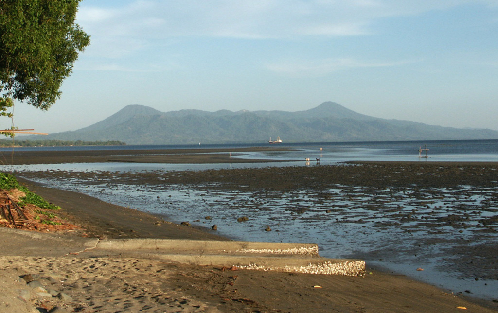
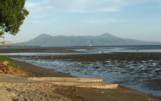 The Krummel-Garbuna-Welcker volcanic complex at the S end of the Willaumez Peninsula, across Stetin Bay. The complex consists of three volcanic peaks, Krummel, Garbuna, and Welcker, along a N-S line. The most prominent peaks, Welcker (right) and Krummel (left), form the N and S sides of the complex, respectively. The lower peaks of the centrally located Garbuna contain a large unvegetated area with an extensive thermal field.