Apparent eruption later discovered to be fires caused by human activity
A Vanuatu Government team visited Hunter Island on 9 March at 1200. White vapor tinged with gray ash billowed to an altitude of approximately 900 m from the main active crater on the W side, and drifted to the W and NW. Fumaroles and two small superimposed craters on the E side were also fuming. Vegetation on the lower slopes of the E coast was burning, which suggested that the eruption had begun recently. By 2200, the fires had reached the central spine of the island and could be clearly seen from the anchorage on the NW coast.
[Later information revealed that human activity had started fires and no eruption had taken place.]
Further Reference. Maillet, P., Monzier, M., and Lefevre, C., 1987, Petrology of Matthew and Hunter volcanoes, South New Hebrides Island Arc (Southwest Pacific): JVGR, v. 30, p. 1-29.
Information Contacts: A. Macfarlane, Dept. of Geology, Mines, and Rural Water Supplies, Vanuatu.
The Global Volcanism Program has no Weekly Reports available for Hunter Island.
Reports are organized chronologically and indexed below by Month/Year (Publication Volume:Number), and include a one-line summary. Click on the index link or scroll down to read the reports.
Apparent eruption later discovered to be fires caused by human activity
A Vanuatu Government team visited Hunter Island on 9 March at 1200. White vapor tinged with gray ash billowed to an altitude of approximately 900 m from the main active crater on the W side, and drifted to the W and NW. Fumaroles and two small superimposed craters on the E side were also fuming. Vegetation on the lower slopes of the E coast was burning, which suggested that the eruption had begun recently. By 2200, the fires had reached the central spine of the island and could be clearly seen from the anchorage on the NW coast.
[Later information revealed that human activity had started fires and no eruption had taken place.]
Further Reference. Maillet, P., Monzier, M., and Lefevre, C., 1987, Petrology of Matthew and Hunter volcanoes, South New Hebrides Island Arc (Southwest Pacific): JVGR, v. 30, p. 1-29.
Information Contacts: A. Macfarlane, Dept. of Geology, Mines, and Rural Water Supplies, Vanuatu.
|
|
||||||||||||||||||||||||||
There is data available for 4 confirmed eruptive periods.
[ 1983 Mar 9 (on or before) ] Discredited Eruption
A government team visited the island on 9 March 1983 and observed vapor and ash cloud rising to 900 m. Vegetation on the lower slopes was burning, suggesting an eruption had begun recently (SEAN). This was actually a vegetation fire, not an eruption (Sinton, 1984, p.c.).
1903 Confirmed Eruption (Explosive / Effusive) VEI: 0
| Episode 1 | Eruption (Explosive / Effusive) | Northern tip of island | ||||||||||||||||||
|---|---|---|---|---|---|---|---|---|---|---|---|---|---|---|---|---|---|---|---|
| 1903 - Unknown | Evidence from Observations: Reported | ||||||||||||||||||
| An eruption in 1903 was listed by Williams and Warden (1964) with no additional details. Maillet et al. (1986) indicated that the last eruption of Hunter Island apparently took place at the very northern tip of the island and produced a narrow lava flow along a sub-vertical fracture. Solfatara fields are abundant at the northern end of the island. | |||||||||||||||||||
|
List of 2 Events for Episode 1 at Northern tip of island
|
|||||||||||||||||||
1895 Nov 24 Confirmed Eruption (Explosive / Effusive)
| Episode 1 | Eruption (Explosive / Effusive) | East side | |||||||||||||||||||||||
|---|---|---|---|---|---|---|---|---|---|---|---|---|---|---|---|---|---|---|---|---|---|---|---|---|
| 1895 Nov 24 - Unknown | Evidence from Observations: Reported | |||||||||||||||||||||||
| An eruption similar to 1841 took place from two craters on the east side (Sapper, 1917). Phillips (1898) cites a ship captain report of large streams of lava pouring down from two craters on the east side. | ||||||||||||||||||||||||
|
List of 3 Events for Episode 1 at East side
|
||||||||||||||||||||||||
[ 1892 ] Uncertain Eruption
| Episode 1 | Eruption (Explosive / Effusive) | ||||
|---|---|---|---|---|
| 1892 - Unknown | Evidence from Unknown | |||
1841 Mar 15 Confirmed Eruption (Explosive / Effusive)
| Episode 1 | Eruption (Explosive / Effusive) | |||||||||||||||||||
|---|---|---|---|---|---|---|---|---|---|---|---|---|---|---|---|---|---|---|---|
| 1841 Mar 15 - Unknown | Evidence from Observations: Reported | ||||||||||||||||||
| White smoke and possible incandescent ejecta was reported on 15 March 1841 (Sapper 1917). | |||||||||||||||||||
|
List of 2 Events for Episode 1
|
|||||||||||||||||||
1835 Confirmed Eruption (Explosive / Effusive)
| Episode 1 | Eruption (Explosive / Effusive) | ||||||||||||||||||||||||
|---|---|---|---|---|---|---|---|---|---|---|---|---|---|---|---|---|---|---|---|---|---|---|---|---|
| 1835 - Unknown | Evidence from Observations: Reported | |||||||||||||||||||||||
| Eruption of flames and lava was reported in 1835 (Sapper, 1917). | ||||||||||||||||||||||||
|
List of 3 Events for Episode 1
|
||||||||||||||||||||||||
[ 1797 ] Uncertain Eruption
| Episode 1 | Eruption (Explosive / Effusive) | ||||
|---|---|---|---|---|
| 1797 - Unknown | Evidence from Unknown | |||
This compilation of synonyms and subsidiary features may not be comprehensive. Features are organized into four major categories: Cones, Craters, Domes, and Thermal Features. Synonyms of features appear indented below the primary name. In some cases additional feature type, elevation, or location details are provided.
Synonyms |
| Fearn Island | Umaenaeg | Leka |
There are no samples for Hunter Island in the Smithsonian's NMNH Department of Mineral Sciences Rock and Ore collection.
| Copernicus Browser | The Copernicus Browser replaced the Sentinel Hub Playground browser in 2023, to provide access to Earth observation archives from the Copernicus Data Space Ecosystem, the main distribution platform for data from the EU Copernicus missions. |
| MIROVA | Middle InfraRed Observation of Volcanic Activity (MIROVA) is a near real time volcanic hot-spot detection system based on the analysis of MODIS (Moderate Resolution Imaging Spectroradiometer) data. In particular, MIROVA uses the Middle InfraRed Radiation (MIR), measured over target volcanoes, in order to detect, locate and measure the heat radiation sourced from volcanic activity. |
| MODVOLC Thermal Alerts | Using infrared satellite Moderate Resolution Imaging Spectroradiometer (MODIS) data, scientists at the Hawai'i Institute of Geophysics and Planetology, University of Hawai'i, developed an automated system called MODVOLC to map thermal hot-spots in near real time. For each MODIS image, the algorithm automatically scans each 1 km pixel within it to check for high-temperature hot-spots. When one is found the date, time, location, and intensity are recorded. MODIS looks at every square km of the Earth every 48 hours, once during the day and once during the night, and the presence of two MODIS sensors in space allows at least four hot-spot observations every two days. Each day updated global maps are compiled to display the locations of all hot spots detected in the previous 24 hours. There is a drop-down list with volcano names which allow users to 'zoom-in' and examine the distribution of hot-spots at a variety of spatial scales. |
|
WOVOdat
Single Volcano View Temporal Evolution of Unrest Side by Side Volcanoes |
WOVOdat is a database of volcanic unrest; instrumentally and visually recorded changes in seismicity, ground deformation, gas emission, and other parameters from their normal baselines. It is sponsored by the World Organization of Volcano Observatories (WOVO) and presently hosted at the Earth Observatory of Singapore.
GVMID Data on Volcano Monitoring Infrastructure The Global Volcano Monitoring Infrastructure Database GVMID, is aimed at documenting and improving capabilities of volcano monitoring from the ground and space. GVMID should provide a snapshot and baseline view of the techniques and instrumentation that are in place at various volcanoes, which can be use by volcano observatories as reference to setup new monitoring system or improving networks at a specific volcano. These data will allow identification of what monitoring gaps exist, which can be then targeted by remote sensing infrastructure and future instrument deployments. |
| Volcanic Hazard Maps | The IAVCEI Commission on Volcanic Hazards and Risk has a Volcanic Hazard Maps database designed to serve as a resource for hazard mappers (or other interested parties) to explore how common issues in hazard map development have been addressed at different volcanoes, in different countries, for different hazards, and for different intended audiences. In addition to the comprehensive, searchable Volcanic Hazard Maps Database, this website contains information about diversity of volcanic hazard maps, illustrated using examples from the database. This site is for educational purposes related to volcanic hazard maps. Hazard maps found on this website should not be used for emergency purposes. For the most recent, official hazard map for a particular volcano, please seek out the proper institutional authorities on the matter. |
| IRIS seismic stations/networks | Incorporated Research Institutions for Seismology (IRIS) Data Services map showing the location of seismic stations from all available networks (permanent or temporary) within a radius of 0.18° (about 20 km at mid-latitudes) from the given location of Hunter Island. Users can customize a variety of filters and options in the left panel. Note that if there are no stations are known the map will default to show the entire world with a "No data matched request" error notice. |
| UNAVCO GPS/GNSS stations | Geodetic Data Services map from UNAVCO showing the location of GPS/GNSS stations from all available networks (permanent or temporary) within a radius of 20 km from the given location of Hunter Island. Users can customize the data search based on station or network names, location, and time window. Requires Adobe Flash Player. |
| DECADE Data | The DECADE portal, still in the developmental stage, serves as an example of the proposed interoperability between The Smithsonian Institution's Global Volcanism Program, the Mapping Gas Emissions (MaGa) Database, and the EarthChem Geochemical Portal. The Deep Earth Carbon Degassing (DECADE) initiative seeks to use new and established technologies to determine accurate global fluxes of volcanic CO2 to the atmosphere, but installing CO2 monitoring networks on 20 of the world's 150 most actively degassing volcanoes. The group uses related laboratory-based studies (direct gas sampling and analysis, melt inclusions) to provide new data for direct degassing of deep earth carbon to the atmosphere. |
| Large Eruptions of Hunter Island | Information about large Quaternary eruptions (VEI >= 4) is cataloged in the Large Magnitude Explosive Volcanic Eruptions (LaMEVE) database of the Volcano Global Risk Identification and Analysis Project (VOGRIPA). |
| EarthChem | EarthChem develops and maintains databases, software, and services that support the preservation, discovery, access and analysis of geochemical data, and facilitate their integration with the broad array of other available earth science parameters. EarthChem is operated by a joint team of disciplinary scientists, data scientists, data managers and information technology developers who are part of the NSF-funded data facility Integrated Earth Data Applications (IEDA). IEDA is a collaborative effort of EarthChem and the Marine Geoscience Data System (MGDS). |


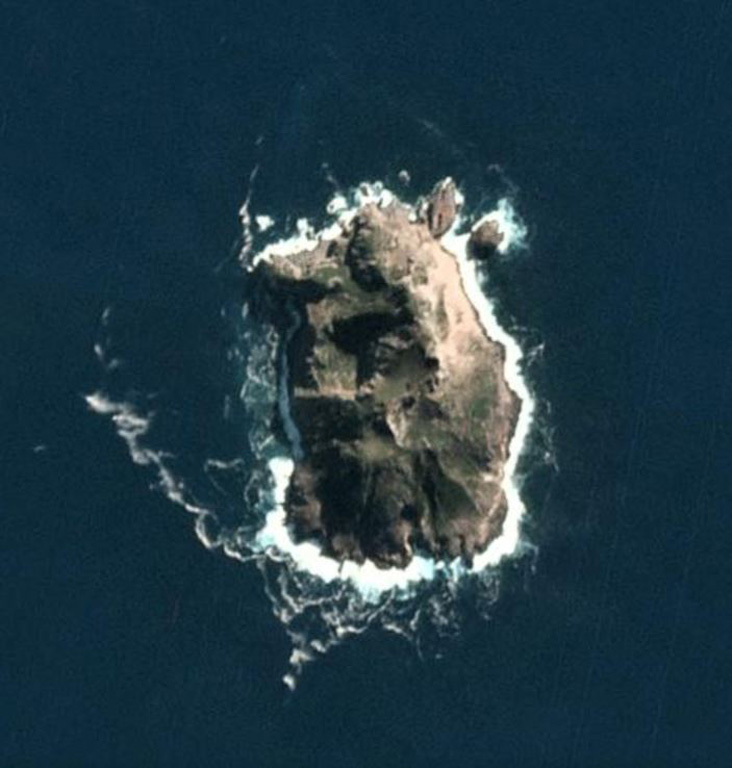
 The roughly 1.1 x 0.8 km Hunter Island in the SE New Hebrides arc is shown in this 14 May 2020 PlanetScope satellite image (N is at the top). Several craters have formed across the island and geothermal activity has been noted on the N, NE, and SE coasts.