On 14 July CVGHM reported that, since the Alert Level for Kaba was raised on 20 October 2009, seismicity had fluctuated but decreased overall. During September 2009-May 2011, when weather permitted, white plumes were seen rising 25-300 m above the crater rim, and during June-July 2011 diffuse white plumes rose 50 m above the crater rim. The Alert Level was lowered to 1 (on a scale of 1-4) on 12 July.
Source: Pusat Vulkanologi dan Mitigasi Bencana Geologi (PVMBG, also known as CVGHM)
Increased seismicity and whitish vapor emissions
Deep volcanic earthquakes, seismic tremor, and five small explosions with corresponding ash emission were reported from Kaba in August 2000 (BGVN 25:11). Since then, Kaba has been quiet, but even in its normal state it almost always emits whitish plumes 25-100 m high.
On 20 October 2009, the Center of Volcanology and Geological Hazard Mitigation (CVGHM) reported that seismic activity from Kaba increased in August and remained elevated into September and October. Inflation was also detected. When weather permitted, diffuse white plumes were seen rising ~ 25-50 m above the summit crater complex and drifting E. Based on the deformation and increased seismicity, CVGHM raised the Alert Level to 2 (on a scale of 1-4).
From January through August 2009, the frequency of deep volcanic earthquakes averaged 85 events per month, but in August the number of events rose to 257 per month. During August-September, whitish plumes remained similar to September-October. In September seismicity fluctuated but tended to increase. Earthquakes and total tremors recorded at Kaba's monitoring post are shown in table 2.
Table 2. Summary of Kaba seismic data recorded during 12 September-20 October 2009. Courtesy of CVGHM.
| Dates (2009) | Deep volcanic earthquakes (Count, Characteristics) | Shallow volcanic earthquakes (Count, Characteristics) | Notes |
| Beginning on 12 September | 343 | 55 | -- |
| 1-17 October | 253. Max. amplitudes of 1-18 mm; S-wave minus P-wave arrival times ("S-P") of 0.2-3.5 s with signals lasting 4-35 s. | 271. Max. amplitudes 0.5-15 mm, durations of 2.5-11 s. | -- |
| 18 October | 68. Max. amplitude of 1-19 mm; S-P times of 0.2-3 s, and a duration of 3.5-47 s. | 67. Max. amplitudes 0.8-16 mm, durations of 2.5-13 s. | -- |
| 19 October | 50. Max. amplitudes of 0.5-18 mm; S-P 0.5-2 s, and a duration of 2-15 s. | 127. Max. amplitudes 0.5-15 mm, durations of 2.5-10 s. | Volcanic tremor registered during 0640-0900 local time; max. amplitudes 0.5-2 mm. |
| 20 October | 29. Max. amplitudes of 0.5-18 mm; S-P 0.5-2 seconds and a duration of 2-15 s. | 21. Max. amplitudes 0.5-15 mm, durations of 2.5-10 s. | Continuous tremor with amplitudes of 1-7 mm; the most prevalent amplitudes 1-3 mm. During clear weather, whitish plumes rose ~ 25 m. |
Deformation measurements taken using an EDM (electronic distance measurement) method were as follows: Biring station, shorter by 10 cm; Voelsang station, longer by 0.4 cm; and Kaba station, shorter by 2 cm.
Measurements of the crater water temperature on 15 October showed a reading of 72°C, with a pH of 3.24. The sulfurous and associated solfatara areas recorded a temperature of around 106-107°C. There was no other activity in the area of the crater.
Information Contacts: Center of Volcanology and Geological Hazard Mitigation (CVGHM), Jalan Diponegoro 57, Bandung 40122, Indonesia (URL: http://vsi.esdm.go.id/).
On 14 July CVGHM reported that, since the Alert Level for Kaba was raised on 20 October 2009, seismicity had fluctuated but decreased overall. During September 2009-May 2011, when weather permitted, white plumes were seen rising 25-300 m above the crater rim, and during June-July 2011 diffuse white plumes rose 50 m above the crater rim. The Alert Level was lowered to 1 (on a scale of 1-4) on 12 July.
Source: Pusat Vulkanologi dan Mitigasi Bencana Geologi (PVMBG, also known as CVGHM)
On 20 October, CVGHM reported that seismic activity from Kaba increased in August and remained elevated in September and October. Inflation was also detected. When weather permitted, diffuse white plumes were seen rising 25-50 m above the crater rim and drifting E. Based on the deformation and increased seismicity, CVGHN raised the Alert Level to 2 (on a scale of 1-4).
Source: Pusat Vulkanologi dan Mitigasi Bencana Geologi (PVMBG, also known as CVGHM)
Reports are organized chronologically and indexed below by Month/Year (Publication Volume:Number), and include a one-line summary. Click on the index link or scroll down to read the reports.
Only solfataric activity accompanies 17 December earthquake
Some press reports indicated that increased activity from Kaba and neighboring Bukit Daun volcanoes preceded a destructive 17 December earthquake. Adjat Sudradjat and Suparto Siswowidjoyo report that no unusual volcanic activity took place. Thick white solfataric vapor was emitted from two craters (Kaba Lama and Kaba Besar) on Kaba, which last erupted in 1956. Temperatures of solfataras and a crater lake at Kaba were measured on several occasions in the past nine years (table 1). Active fumaroles are present on Bukit Daun, but the volcano has not erupted in historic time.
Table 1. Temperatures of solfataras and a crater lake at Kaba, 1971, 1976, and 1978. Courtesy of VSI.
| Area | 1971 | 1976 | 1978 |
| Solfataras | 110°C | 156°C | 123°C |
| Crater Lake | 45°C | -- | 34°C |
Information Contacts: A. Sudradjat, VSI; Suparto S., Java and Sumatra Observatory, VSI.
Explosions and light gray ash
This report covers activity at Kaba documented by the Volcanological Survey of Indonesia (VSI) during August 2000. Deep volcanic earthquakes dominated seismicity during the second week of August. On 17 August seismographs recorded harmonic tremor with a maximum amplitude of 14 mm. Visual observations were hindered by clouds around the summit until the third week of the month. During 22-28 August, conditions were clear and a light gray ash plume rose 200 m above the summit. Five small explosion earthquakes were registered on 26-27 August, corresponding to the same number of observed ash emissions. By the end of August, the number of deep volcanic earthquakes decreased. Kaba remained at a hazard status of 2 (on a scale of 1-4) throughout the month.
Information Contacts: Dali Ahmad, Volcanological Survey of Indonesia (VSI), Jalan Diponegoro No. 57, Bandung 40122, Indonesia (URL: http://www.vsi.esdm.go.id/).
Increased seismicity and whitish vapor emissions
Deep volcanic earthquakes, seismic tremor, and five small explosions with corresponding ash emission were reported from Kaba in August 2000 (BGVN 25:11). Since then, Kaba has been quiet, but even in its normal state it almost always emits whitish plumes 25-100 m high.
On 20 October 2009, the Center of Volcanology and Geological Hazard Mitigation (CVGHM) reported that seismic activity from Kaba increased in August and remained elevated into September and October. Inflation was also detected. When weather permitted, diffuse white plumes were seen rising ~ 25-50 m above the summit crater complex and drifting E. Based on the deformation and increased seismicity, CVGHM raised the Alert Level to 2 (on a scale of 1-4).
From January through August 2009, the frequency of deep volcanic earthquakes averaged 85 events per month, but in August the number of events rose to 257 per month. During August-September, whitish plumes remained similar to September-October. In September seismicity fluctuated but tended to increase. Earthquakes and total tremors recorded at Kaba's monitoring post are shown in table 2.
Table 2. Summary of Kaba seismic data recorded during 12 September-20 October 2009. Courtesy of CVGHM.
| Dates (2009) | Deep volcanic earthquakes (Count, Characteristics) | Shallow volcanic earthquakes (Count, Characteristics) | Notes |
| Beginning on 12 September | 343 | 55 | -- |
| 1-17 October | 253. Max. amplitudes of 1-18 mm; S-wave minus P-wave arrival times ("S-P") of 0.2-3.5 s with signals lasting 4-35 s. | 271. Max. amplitudes 0.5-15 mm, durations of 2.5-11 s. | -- |
| 18 October | 68. Max. amplitude of 1-19 mm; S-P times of 0.2-3 s, and a duration of 3.5-47 s. | 67. Max. amplitudes 0.8-16 mm, durations of 2.5-13 s. | -- |
| 19 October | 50. Max. amplitudes of 0.5-18 mm; S-P 0.5-2 s, and a duration of 2-15 s. | 127. Max. amplitudes 0.5-15 mm, durations of 2.5-10 s. | Volcanic tremor registered during 0640-0900 local time; max. amplitudes 0.5-2 mm. |
| 20 October | 29. Max. amplitudes of 0.5-18 mm; S-P 0.5-2 seconds and a duration of 2-15 s. | 21. Max. amplitudes 0.5-15 mm, durations of 2.5-10 s. | Continuous tremor with amplitudes of 1-7 mm; the most prevalent amplitudes 1-3 mm. During clear weather, whitish plumes rose ~ 25 m. |
Deformation measurements taken using an EDM (electronic distance measurement) method were as follows: Biring station, shorter by 10 cm; Voelsang station, longer by 0.4 cm; and Kaba station, shorter by 2 cm.
Measurements of the crater water temperature on 15 October showed a reading of 72°C, with a pH of 3.24. The sulfurous and associated solfatara areas recorded a temperature of around 106-107°C. There was no other activity in the area of the crater.
Information Contacts: Center of Volcanology and Geological Hazard Mitigation (CVGHM), Jalan Diponegoro 57, Bandung 40122, Indonesia (URL: http://vsi.esdm.go.id/).
|
|
||||||||||||||||||||||||||
There is data available for 11 confirmed eruptive periods.
2000 Aug 22 (?) - 2000 Aug 27 (?) Confirmed Eruption (Explosive / Effusive) VEI: 1
| Episode 1 | Eruption (Explosive / Effusive) | ||||||||||||||||||||||||||||||||||
|---|---|---|---|---|---|---|---|---|---|---|---|---|---|---|---|---|---|---|---|---|---|---|---|---|---|---|---|---|---|---|---|---|---|---|
| 2000 Aug 22 (?) - 2000 Aug 27 (?) | Evidence from Observations: Reported | |||||||||||||||||||||||||||||||||
|
List of 5 Events for Episode 1
|
||||||||||||||||||||||||||||||||||
1956 Mar 22 - 1956 Mar 28 Confirmed Eruption (Explosive / Effusive) VEI: 2
| Episode 1 | Eruption (Explosive / Effusive) | |||||||||||||||||||||||||||||
|---|---|---|---|---|---|---|---|---|---|---|---|---|---|---|---|---|---|---|---|---|---|---|---|---|---|---|---|---|---|
| 1956 Mar 22 - 1956 Mar 28 | Evidence from Observations: Reported | ||||||||||||||||||||||||||||
|
List of 4 Events for Episode 1
|
|||||||||||||||||||||||||||||
1952 Apr 1 - 1952 Apr 28 Confirmed Eruption (Explosive / Effusive) VEI: 2
| Episode 1 | Eruption (Explosive / Effusive) | |||||||||||||||||||||||||||||
|---|---|---|---|---|---|---|---|---|---|---|---|---|---|---|---|---|---|---|---|---|---|---|---|---|---|---|---|---|---|
| 1952 Apr 1 - 1952 Apr 28 | Evidence from Observations: Reported | ||||||||||||||||||||||||||||
|
List of 4 Events for Episode 1
|
|||||||||||||||||||||||||||||
1950 Mar 16 ± 15 days - 1951 Apr 16 ± 15 days Confirmed Eruption (Explosive / Effusive) VEI: 1
| Episode 1 | Eruption (Explosive / Effusive) | Kaba Vogelsang | ||||||||||||||||||||||||||||||||||||||||||||||||
|---|---|---|---|---|---|---|---|---|---|---|---|---|---|---|---|---|---|---|---|---|---|---|---|---|---|---|---|---|---|---|---|---|---|---|---|---|---|---|---|---|---|---|---|---|---|---|---|---|---|
| 1950 Mar 16 ± 15 days - 1951 Apr 16 ± 15 days | Evidence from Observations: Reported | ||||||||||||||||||||||||||||||||||||||||||||||||
|
List of 8 Events for Episode 1 at Kaba Vogelsang
|
|||||||||||||||||||||||||||||||||||||||||||||||||
1939 Nov 19 - 1941 Mar 14 Confirmed Eruption (Explosive / Effusive) VEI: 2
| Episode 1 | Eruption (Explosive / Effusive) | Kaba Baru, Kaba Lama | |||||||||||||||||||||||||||||||||
|---|---|---|---|---|---|---|---|---|---|---|---|---|---|---|---|---|---|---|---|---|---|---|---|---|---|---|---|---|---|---|---|---|---|---|
| 1939 Nov 19 - 1941 Mar 14 | Evidence from Observations: Reported | |||||||||||||||||||||||||||||||||
|
List of 5 Events for Episode 1 at Kaba Baru, Kaba Lama
|
||||||||||||||||||||||||||||||||||
[ 1918 Aug 9 ] Uncertain Eruption
| Episode 1 | Eruption (Explosive / Effusive) | |||||||||||||||||||
|---|---|---|---|---|---|---|---|---|---|---|---|---|---|---|---|---|---|---|---|
| 1918 Aug 9 - Unknown | Evidence from Unknown | ||||||||||||||||||
|
List of 2 Events for Episode 1
|
|||||||||||||||||||
1907 Confirmed Eruption (Explosive / Effusive) VEI: 2
| Episode 1 | Eruption (Explosive / Effusive) | Kaba Baru | ||||||||||||||||||
|---|---|---|---|---|---|---|---|---|---|---|---|---|---|---|---|---|---|---|---|
| 1907 - Unknown | Evidence from Observations: Reported | ||||||||||||||||||
|
List of 2 Events for Episode 1 at Kaba Baru
|
|||||||||||||||||||
1873 - 1892 Nov 1 ± 30 days Confirmed Eruption (Explosive / Effusive) VEI: 2
| Episode 1 | Eruption (Explosive / Effusive) | Kaba Volgelsang and Kaba Baru | |||||||||||||||||||||||||||||||||
|---|---|---|---|---|---|---|---|---|---|---|---|---|---|---|---|---|---|---|---|---|---|---|---|---|---|---|---|---|---|---|---|---|---|---|
| 1873 - 1892 Nov 1 ± 30 days | Evidence from Observations: Reported | |||||||||||||||||||||||||||||||||
|
List of 5 Events for Episode 1 at Kaba Volgelsang and Kaba Baru
|
||||||||||||||||||||||||||||||||||
1868 Oct - 1869 Confirmed Eruption (Explosive / Effusive) VEI: 2
| Episode 1 | Eruption (Explosive / Effusive) | Kaba Baru ? and Kaba Vogelsang | |||||||||||||||||||||||
|---|---|---|---|---|---|---|---|---|---|---|---|---|---|---|---|---|---|---|---|---|---|---|---|---|
| 1868 Oct - 1869 | Evidence from Observations: Reported | |||||||||||||||||||||||
|
List of 3 Events for Episode 1 at Kaba Baru ? and Kaba Vogelsang
|
||||||||||||||||||||||||
1853 Nov Confirmed Eruption (Explosive / Effusive) VEI: 2
| Episode 1 | Eruption (Explosive / Effusive) | |||||||||||||||||||||||||||||
|---|---|---|---|---|---|---|---|---|---|---|---|---|---|---|---|---|---|---|---|---|---|---|---|---|---|---|---|---|---|
| 1853 Nov - Unknown | Evidence from Observations: Reported | ||||||||||||||||||||||||||||
|
List of 4 Events for Episode 1
|
|||||||||||||||||||||||||||||
[ 1838 ] Uncertain Eruption
| Episode 1 | Eruption (Explosive / Effusive) | ||||
|---|---|---|---|---|
| 1838 - Unknown | Evidence from Unknown | |||
1834 Nov Confirmed Eruption (Explosive / Effusive) VEI: 2
| Episode 1 | Eruption (Explosive / Effusive) | ||||||||||||||||||||||||
|---|---|---|---|---|---|---|---|---|---|---|---|---|---|---|---|---|---|---|---|---|---|---|---|---|
| 1834 Nov - Unknown | Evidence from Observations: Reported | |||||||||||||||||||||||
|
List of 3 Events for Episode 1
|
||||||||||||||||||||||||
1833 Nov 24 - 1833 Nov 25 Confirmed Eruption (Explosive / Effusive) VEI: 2
| Episode 1 | Eruption (Explosive / Effusive) | |||||||||||||||||||||||||||||||||||||||
|---|---|---|---|---|---|---|---|---|---|---|---|---|---|---|---|---|---|---|---|---|---|---|---|---|---|---|---|---|---|---|---|---|---|---|---|---|---|---|---|
| 1833 Nov 24 - 1833 Nov 25 | Evidence from Observations: Reported | ||||||||||||||||||||||||||||||||||||||
|
List of 6 Events for Episode 1
|
|||||||||||||||||||||||||||||||||||||||
This compilation of synonyms and subsidiary features may not be comprehensive. Features are organized into four major categories: Cones, Craters, Domes, and Thermal Features. Synonyms of features appear indented below the primary name. In some cases additional feature type, elevation, or location details are provided.
Synonyms |
||||
| Kaaba | ||||
Cones |
||||
| Feature Name | Feature Type | Elevation | Latitude | Longitude |
| Hitam
Bukit Itam |
Stratovolcano | 1907 m | 3° 31' 39.00" S | 102° 36' 4.00" E |
| Kaba | Stratovolcano | 1926 m | 3° 30' 56.00" S | 102° 37' 16.00" E |
| Melintang, Bukit | Cone - Crater | 1962 m | 3° 31' 14.00" S | 102° 36' 54.00" E |
| Solajuang | Cone | 1829 m | 3° 31' 17.00" S | 102° 38' 25.00" E |
Craters |
||||
| Feature Name | Feature Type | Elevation | Latitude | Longitude |
| Lama, Kawah
Besar Hidup |
Crater | 1715 m | 3° 30' 55.00" S | 102° 37' 34.00" E |
| Mati, Kawah
Kecil Ketjil Baru |
Crater | 1695 m | 3° 30' 43.00" S | 102° 37' 56.00" E |
| Vogelsang
Pendapuran Penjeluang Penyeluang Vogelenzang |
Crater | 1680 m | 3° 30' 38.00" S | 102° 38' 15.00" E |
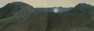 A small plume rises from Kaba Kecil, the middle of three summit craters on Kaba volcano, viewed from the ENE at Vogelsang Peak on the upper NNE flank. The Bukit Biring peak is to the left of Kaba Kecil crater and Bukit Kaba peak is to the right. The far wall of Kaba Lama crater, the largest crater at Kaba, forms the center horizon.
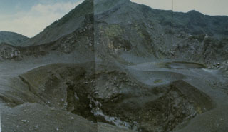 Kaba is a low, elongated volcano with a summit containing three historically active craters that decrease in size towards the ENE. The central crater seen in this photo has been the source of most historical eruptions, along with two other craters that have also been active. Small lakes have formed in all craters at various times.
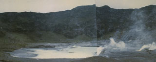 Fumaroles produce plumes along the floor and margins of Kawah Besar, a small crater with a shallow crater lake occupying Kaba Lama. This is the largest and westernmost of three major craters at the summit of Kaba volcano. The rim of 1.2-km-wide Kaba Lama forms the horizon.
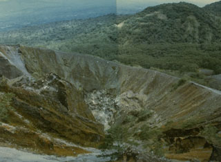 An eruption during 1950-51 formed the crater in the foreground within the larger Kaba Vogelsang crater on the upper ENE flank of Kaba volcano. The eruption began in March 1950 and lasted until April of the following year. An eruption on 7 March 1951 resulted in ashfall that destroyed forests on the volcano, and incandescent bombs were ejected on 2 March.
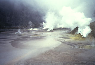 A dense plume emanates from fumaroles occupying the floor of Kaba Lama, the largest of the three major summit craters of Kaba volcano. A shallow lake occupying the crater floor is one of several in the Kaba crater complex.
 Gunung Kaba, rising above farmlands at Pematang Danau, has three large historically active craters trending ENE from the summit to the upper NE flank. The SW-most crater is the largest. Most historical activity has consisted of explosive eruptions that affected only the summit region of the volcano. They originated from the central summit craters, although the upper-NE flank crater Kawah Vogelsang also produced explosions during the 19th and 20th centuries.
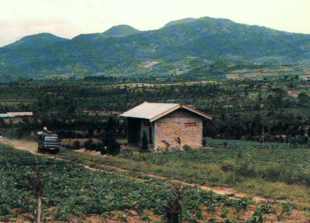
There are no samples for Kaba in the Smithsonian's NMNH Department of Mineral Sciences Rock and Ore collection.
| Copernicus Browser | The Copernicus Browser replaced the Sentinel Hub Playground browser in 2023, to provide access to Earth observation archives from the Copernicus Data Space Ecosystem, the main distribution platform for data from the EU Copernicus missions. |
| MIROVA | Middle InfraRed Observation of Volcanic Activity (MIROVA) is a near real time volcanic hot-spot detection system based on the analysis of MODIS (Moderate Resolution Imaging Spectroradiometer) data. In particular, MIROVA uses the Middle InfraRed Radiation (MIR), measured over target volcanoes, in order to detect, locate and measure the heat radiation sourced from volcanic activity. |
| MODVOLC Thermal Alerts | Using infrared satellite Moderate Resolution Imaging Spectroradiometer (MODIS) data, scientists at the Hawai'i Institute of Geophysics and Planetology, University of Hawai'i, developed an automated system called MODVOLC to map thermal hot-spots in near real time. For each MODIS image, the algorithm automatically scans each 1 km pixel within it to check for high-temperature hot-spots. When one is found the date, time, location, and intensity are recorded. MODIS looks at every square km of the Earth every 48 hours, once during the day and once during the night, and the presence of two MODIS sensors in space allows at least four hot-spot observations every two days. Each day updated global maps are compiled to display the locations of all hot spots detected in the previous 24 hours. There is a drop-down list with volcano names which allow users to 'zoom-in' and examine the distribution of hot-spots at a variety of spatial scales. |
|
WOVOdat
Single Volcano View Temporal Evolution of Unrest Side by Side Volcanoes |
WOVOdat is a database of volcanic unrest; instrumentally and visually recorded changes in seismicity, ground deformation, gas emission, and other parameters from their normal baselines. It is sponsored by the World Organization of Volcano Observatories (WOVO) and presently hosted at the Earth Observatory of Singapore.
GVMID Data on Volcano Monitoring Infrastructure The Global Volcano Monitoring Infrastructure Database GVMID, is aimed at documenting and improving capabilities of volcano monitoring from the ground and space. GVMID should provide a snapshot and baseline view of the techniques and instrumentation that are in place at various volcanoes, which can be use by volcano observatories as reference to setup new monitoring system or improving networks at a specific volcano. These data will allow identification of what monitoring gaps exist, which can be then targeted by remote sensing infrastructure and future instrument deployments. |
| Volcanic Hazard Maps | The IAVCEI Commission on Volcanic Hazards and Risk has a Volcanic Hazard Maps database designed to serve as a resource for hazard mappers (or other interested parties) to explore how common issues in hazard map development have been addressed at different volcanoes, in different countries, for different hazards, and for different intended audiences. In addition to the comprehensive, searchable Volcanic Hazard Maps Database, this website contains information about diversity of volcanic hazard maps, illustrated using examples from the database. This site is for educational purposes related to volcanic hazard maps. Hazard maps found on this website should not be used for emergency purposes. For the most recent, official hazard map for a particular volcano, please seek out the proper institutional authorities on the matter. |
| IRIS seismic stations/networks | Incorporated Research Institutions for Seismology (IRIS) Data Services map showing the location of seismic stations from all available networks (permanent or temporary) within a radius of 0.18° (about 20 km at mid-latitudes) from the given location of Kaba. Users can customize a variety of filters and options in the left panel. Note that if there are no stations are known the map will default to show the entire world with a "No data matched request" error notice. |
| UNAVCO GPS/GNSS stations | Geodetic Data Services map from UNAVCO showing the location of GPS/GNSS stations from all available networks (permanent or temporary) within a radius of 20 km from the given location of Kaba. Users can customize the data search based on station or network names, location, and time window. Requires Adobe Flash Player. |
| DECADE Data | The DECADE portal, still in the developmental stage, serves as an example of the proposed interoperability between The Smithsonian Institution's Global Volcanism Program, the Mapping Gas Emissions (MaGa) Database, and the EarthChem Geochemical Portal. The Deep Earth Carbon Degassing (DECADE) initiative seeks to use new and established technologies to determine accurate global fluxes of volcanic CO2 to the atmosphere, but installing CO2 monitoring networks on 20 of the world's 150 most actively degassing volcanoes. The group uses related laboratory-based studies (direct gas sampling and analysis, melt inclusions) to provide new data for direct degassing of deep earth carbon to the atmosphere. |
| Large Eruptions of Kaba | Information about large Quaternary eruptions (VEI >= 4) is cataloged in the Large Magnitude Explosive Volcanic Eruptions (LaMEVE) database of the Volcano Global Risk Identification and Analysis Project (VOGRIPA). |
| EarthChem | EarthChem develops and maintains databases, software, and services that support the preservation, discovery, access and analysis of geochemical data, and facilitate their integration with the broad array of other available earth science parameters. EarthChem is operated by a joint team of disciplinary scientists, data scientists, data managers and information technology developers who are part of the NSF-funded data facility Integrated Earth Data Applications (IEDA). IEDA is a collaborative effort of EarthChem and the Marine Geoscience Data System (MGDS). |

