The Pusat Vulkanologi dan Mitigasi Bencana Geologi (PVMBG) reported increased seismicity at Ranakah. During 1 November-2 December field observers noted typical diffuse white plumes rising from the NW and SW bases of the lava dome. Though seismicity was dominated by tectonic earthquakes, the number of low-frequency earthquakes significantly increased compared to October. Seismic data also indicated the emergence of both shallow and deep volcanic earthquakes. At 0800 on 3 December the Alert Level was raised to 2 (on a scale of 1-4) and the public was warned to stay 1 km away from the crater.
Source: Pusat Vulkanologi dan Mitigasi Bencana Geologi (PVMBG, also known as CVGHM)
Weak ash emissions
Periodic weak ash emissions (15-20 m high) continued in March from cracks in the lava dome, although no dome growth was noted. Averages of five tectonic earthquakes, two volcanic earthquakes, and one earthquake associated with dome collapse, were recorded daily.
Information Contacts: W. Modjo, VSI; AP.
2024: November
2012: April
2011: August
| September
| October
The Pusat Vulkanologi dan Mitigasi Bencana Geologi (PVMBG) reported increased seismicity at Ranakah. During 1 November-2 December field observers noted typical diffuse white plumes rising from the NW and SW bases of the lava dome. Though seismicity was dominated by tectonic earthquakes, the number of low-frequency earthquakes significantly increased compared to October. Seismic data also indicated the emergence of both shallow and deep volcanic earthquakes. At 0800 on 3 December the Alert Level was raised to 2 (on a scale of 1-4) and the public was warned to stay 1 km away from the crater.
Source: Pusat Vulkanologi dan Mitigasi Bencana Geologi (PVMBG, also known as CVGHM)
CVGHM reported that during January-8 April white plumes rose 10-15 m above the Anak Ranakah lava dome and seismicity decreased. On 9 April the Alert Level was lowered to 1 (on a scale of 1-4).
Source: Pusat Vulkanologi dan Mitigasi Bencana Geologi (PVMBG, also known as CVGHM)
CVGHM reported that throughout September and during 1-12 October diffuse white plumes rose 10-15 m above the Anak Ranakah lava dome. Plumes were not observed during 13-21 October. Starting on 1 July, seismicity had increased to a peak level on 15 August then declined through 20 October. Based on visual observations, seismicity, and deformation data, CVGHM lowered the Alert Level to 2 (on a scale of 1-4) on 22 October.
Source: Pusat Vulkanologi dan Mitigasi Bencana Geologi (PVMBG, also known as CVGHM)
Based on visual observations and seismic data analyses of the Anak Ranakah lava dome since December 2010, CVGHM raised the Alert Level on 26 August to 2 (on a scale of 1-4). During 26 August-7 September white plumes rose 5-10 m above the lava dome. Seismic activity continued to increase, prompting CVGHM to again raised the Alert Level, to 3, on 8 September.
Source: Pusat Vulkanologi dan Mitigasi Bencana Geologi (PVMBG, also known as CVGHM)
CVGHM reported that observers of Anak Ranakah, a lava dome that formed in 1987 at the base of the large older lava dome of Ranakah, noted white plumes rising up to 10 m high during January-24 August. Seismicity initially increased in December 2010, but increased again during June-August. Based on visual observations and seismic data analyses, CVGHM raised the Alert Level to 2 (on a scale of 1-4) on 26 August.
Source: Pusat Vulkanologi dan Mitigasi Bencana Geologi (PVMBG, also known as CVGHM)
Reports are organized chronologically and indexed below by Month/Year (Publication Volume:Number), and include a one-line summary. Click on the index link or scroll down to read the reports.
Explosions, then lava plug forms in crater within area of no known historic activity
Explosions began at 2200 on 28 December from a pre-existing crater [(Anak Ranakah)] in an area without known historical eruptive activity (figure 1).
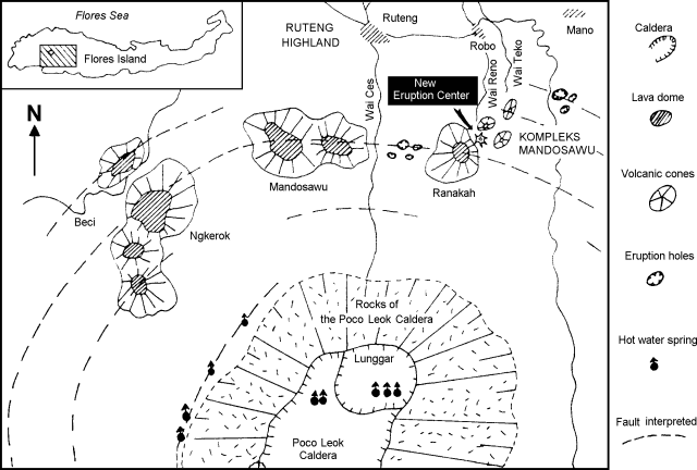 |
Figure 1. Geological sketch map (after Katili, 1988) showing the position of Anak Ranakah (labeled "new eruption center") in relation to other young domes and vents on the flanks of the Poco Leok caldera. |
From 28 December to 2 January numerous explosions sent columns 500-2,000 m above the vent. By 1 January, the vent diameter was ~ 100 m and ~ 40 cm of ashfall had accumulated near the rim. The ash was hot, but did not burn vegetation. Ballistic fragments of light-colored porphyritic dacite, up to 15 cm in diameter, were found in the ash deposits within several hundred meters of the crater rim. The rock fragments and ash were older hydrothermally altered volcanic rocks. Through 1 January there was no evidence for new magmatic material in the deposits. Larger explosions on 3 January (at 1611 and 1646) sent dark ash plumes to 4 and 6 km above the summit, dropping 1 mm of ash in Ruteng (8 km NW) and ~ 3 mm in Robo village (~ 4.5 km NNW). At 0322 on 4 January, a third large explosion occurred. As of 6 January, 20,000 people had been evacuated from an area within a 5 km radius of the vent.
A VSI observer arrived in Ruteng on 30 December and was joined by two additional observers with a seismometer and radio on 1 January. Preliminary seismic data showed roughly 2-4 tectonic earthquakes and ~ 50 volcanic earthquakes/day. An observatory post has been established at Robo village, equipped with a short-period seismometer and a radio for direct communications with VSI headquarters. A second two-person team of VSI observers with an additional seismometer arrived 5 January.
Local officials reported "fire" at the crater associated with the first explosion on 28 December, but no incandescence or lightning had accompanied subsequent larger explosions. A glow from the vent was first observed during the evening of 8 January. When VSI observers visited the crater on 11 January, they confirmed that a new plug of lava had risen 50-75 m within the crater. . . .
Previous seismic activity includes a M 5.6 earthquake that struck the Ruteng area on 7 August 1982 at 0440, damaging the microwave station near the presently active crater and other buildings.
Reference. Katili, J.A., 1988, Anak Ranaka: the birth of a volcano in Flores: Voice of Nature, n. 57, p. 6-11, 50-51.
Information Contacts: VSI.
Explosions and lava from newly active volcano
Numerous explosions from 28 December 1987 to 9 January 1988 sent ash columns to 500-6,000 m height. There was no evidence of new magmatic material in the deposits through 9 January but a glow above the crater was noticed that day. Two days later, lava was visible within the crater. The arrival of lava coincided with a change in signals recorded by portable seismographs: from A-and B-type earthquakes to rockfall avalanches on 9 January. Only rockfalls have been recorded since then.
Between 10 and 14 January lava nearly filled the crater. Numerous large explosions, originally from rockfall avalanches off the new dome N into the steep-walled Wai Reno drainage, were reported on 12 and 13 January. The largest, at about 0530 on the 12th, produced a nuée ardente d'avalanche that traveled ~ 5 km N down the Wai Reno drainage. It knocked over and singed trees in an area of dense jungle as much as 1 km wide before stopping 700 m from the highway. After 14 January large avalanche explosions greatly diminished and lava began creeping into the Wai Reno drainage. From 14 to 21 January, most growth was in the flow rather than in the dome. On 22 January the flow was ~ 300-350 m long, 200 m wide, and 40 m thick, with a volume of 2.5-3.0 x 10⁶ m3. Lava dome volume on 23 January was roughly 5 x 10⁶ m3, and another 1.5 x 10⁶ m3 of new lava was estimated to have fallen from the flow and dome as rockfall avalanches. At the end of January the lava dome was protruding ~100 m above the crater rim (~150-170 m above the floor of the crater).
On 22 January at 0520 a large rockfall avalanche from the E margin of the dome moved ~ 0.5 km E into the valley between Ranakah and Mandasowu. It flattened dense jungle E of the dome and stripped and singed leaves at its perimeter. The avalanche was sufficiently mobile to follow a narrow NE drainage around a small hill (Bukit Timur) before sending a little material into the Wai Reno drainage. Rockfalls from the N lava lobe diminished after 23 January and most new lava continued to flow from the dome into the flat area to the E. Rates of lava extrusion averaged roughly 500,000 m3/day. As of 26 January, 4,200 inhabitants of the sparsely populated area N of Anak Ranakah had been evacuated to the city of Ruteng (population ~ 49,000). A VSI observation post has been established at Poka village, ~7 km NNW of the vent. Three radio-telemetered seismometers have been installed on the N side of the Wai Reno drainage.
A VSI field party observed evidence for at least three former episodes of block and ash avalanching from prehistoric domes or flows into the Wai Reno drainage. In hand specimen, these lavas were characterized as plagioclase-andesite to dacite with differing proportions of hornblende, plagioclase, biotite, and pyroxene.
Information Contacts: VSI.
Continued lava extrusion
The eruption continued through February. No explosions have been reported since 9 January, and seismicity since then has been limited to rockfall events from the growing lava extrusion. Photographs taken in late February indicate that the summit of the steep-sided lava dome was considerably higher than it had been during field work by VSI personnel a month earlier. Lava flows extending N and E from the dome had advanced further, and a new flow had emerged from the dome and moved S. Eruption rates appeared to slow during February to an average of roughly 200,000 m3/day.
Information Contacts: VSI.
Continued lava extrusion; large cloud; chemistry
The eruption continued through March. When surveyed in late February, the volume of the lava dome was ~ 11.5 x 10⁶ m3; the lava tongue descending the N side of the lava dome had a volume of ~ 4.8 x 10⁶ m3.
On 30 March at 0155, the crew of British Airways flight 11 (Singapore to Sydney) observed a large black cloud [over Indonesia] at 12.73°S, 119.30°E, roughly 450 km SSW of the volcano. The cloud was aligned N-S, well above the aircraft's 10 km flight level. A satellite image 25 minutes earlier showed a large convective cloud NE of the aircraft's position. However, a GMS image on 30 March at 0200, just after the aircraft observation, and others at 1100 on 29 and 30 March (NOAA 9 polar orbiter), showed heavy thunderstorm activity that can often both mimic eruption clouds and mask any that might be present. VSI observers reported that a large rockfall avalanche from the N side of the lava dome sent a glowing avalanche ~ 1.5 km down the Wai Reno valley on 30 March at 1930.
A hornblende pyroxene plagioclase andesite sample collected in late January was analyzed by the USGS using X-ray fluorescence.
Information Contacts: VSI; J. Latter, DSIR Geophysics, New Zealand [info from NZ Meteorological Service]; O. Karst, SAB.
Continued lava extrusion
Lava production . . . continued in April. When geologists visited the volcano on 15 April, the summit of the lava dome had reached ~ 2,190 ± 10 m above sea level, an increase of ~50 m since late January. Lava extrusion has occurred primarily to the N, into the Wai Reno drainage. Very little growth of the lava dome has occurred to the W, E, or S. Rockfall avalanches from the growing dome occurred at the rate of ~90/day during April.
Information Contacts: VSI.
Continued lava dome growth
The dome continued to grow during May, spawning ~ 50 rockfall avalanches/day . . . .
Information Contacts: VSI.
Lava flow and dome growth slow
Since the eruption began in December, lava dome height has increased 150 m, and the N lava flow volume has grown by 2.5-3.0 x 10⁶ m3. The growth of the dome and flow slowed in June. Rockfall avalanches detected on the seismometer decreased . . . to an average of 40-50/day in June.
Information Contacts: VSI.
Lava extrusion slows
In July, the lava dome and N flow continued to grow, but at slower rates than in previous months. Rockfalls detected on the seismometer decreased . . . to 30-50/day.
Information Contacts: VSI.
Lava production slows
Lava production had been gradually declining for several months and continued to decrease during August. Collapse of incandescent material was no longer visible, although collapse episodes were recorded seismically an average of six times daily, down from an average of 40-50/day in July. Tectonic earthquakes also averaged 6/day, but no volcanic seismicity was registered.
Information Contacts: VSI.
Dome growth apparently ended; solfatara plume
In November 1989, a white plume rose to 25 m above the solfatara field between the new Anak Ranakah dome and the older [Gunung] Ranakah. A seismograph recorded 121 distant and 15 local tectonic earthquakes, eight A-type and two B-type shocks, and 87 collapse events.
Information Contacts: VSI.
Weak ash emissions
Periodic weak ash emissions (15-20 m high) continued in March from cracks in the lava dome, although no dome growth was noted. Averages of five tectonic earthquakes, two volcanic earthquakes, and one earthquake associated with dome collapse, were recorded daily.
Information Contacts: W. Modjo, VSI; AP.
|
|
||||||||||||||||||||||||||
There is data available for 2 confirmed Holocene eruptive periods.
1991 Mar 16 (on or before) ± 15 days Confirmed Eruption (Explosive / Effusive) VEI: 1
| Episode 1 | Eruption (Explosive / Effusive) | Anak Ranakah | ||||||||||||||||||||||||
|---|---|---|---|---|---|---|---|---|---|---|---|---|---|---|---|---|---|---|---|---|---|---|---|---|---|
| 1991 Mar 16 (on or before) ± 15 days - Unknown | Evidence from Observations: Reported | ||||||||||||||||||||||||
|
List of 3 Events for Episode 1 at Anak Ranakah
|
|||||||||||||||||||||||||
1987 Dec 28 - 1989 Apr 16 (on or after) ± 15 days Confirmed Eruption (Explosive / Effusive) VEI: 3
| Episode 1 | Eruption (Explosive / Effusive) | Anak Ranakah | |||||||||||||||||||||||||||||||||||||||||||||||||||||||||||
|---|---|---|---|---|---|---|---|---|---|---|---|---|---|---|---|---|---|---|---|---|---|---|---|---|---|---|---|---|---|---|---|---|---|---|---|---|---|---|---|---|---|---|---|---|---|---|---|---|---|---|---|---|---|---|---|---|---|---|---|---|
| 1987 Dec 28 - 1989 Apr 16 (on or after) ± 15 days | Evidence from Observations: Reported | |||||||||||||||||||||||||||||||||||||||||||||||||||||||||||
|
List of 10 Events for Episode 1 at Anak Ranakah
|
||||||||||||||||||||||||||||||||||||||||||||||||||||||||||||
This compilation of synonyms and subsidiary features may not be comprehensive. Features are organized into four major categories: Cones, Craters, Domes, and Thermal Features. Synonyms of features appear indented below the primary name. In some cases additional feature type, elevation, or location details are provided.
Domes |
||||
| Feature Name | Feature Type | Elevation | Latitude | Longitude |
| Anak Ranakah | Dome | 2187 m | 8° 38' 1.00" S | 120° 31' 58.00" E |
| Mandasowu, Poco
Mandasowu, Gunung |
Dome | 2368 m | 8° 39' 6.00" S | 120° 26' 53.00" E |
| Ranakah, Pocok | Dome | 2140 m | ||
 Ash clouds rise above incandescent rockfall from collapse of a growing lava dome on February 15, 1988. Anak Ranakah dome began forming on December 28, 1987, in an area without previous historical activity. Dome growth continued into 1989.
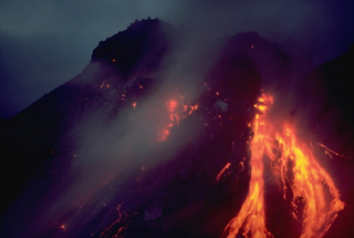 A nighttime view shows incandescent rockfall on February 21, 1988, associated with growth of Anak Ranakah lava dome on Indonesia's Flores Island. The new lava dome began forming on December 28, 1987, and reached a height of 150 m by June 1988.
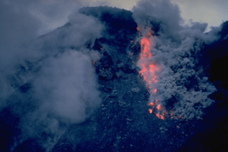
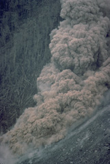 A small pyroclastic flow generated by collapse of a growing lava dome descends the flank of Anak Ranakah dome on February 2, 1988.
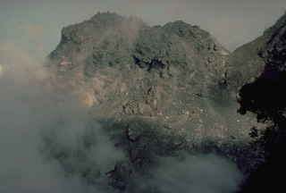 Anak Ranakah, a new lava dome that began growing on December 28, 1987, is seen here on February 25, 1988. By June of 1988 the dome had reached a height of 150 m.
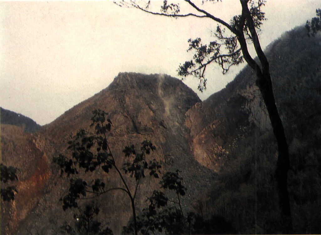
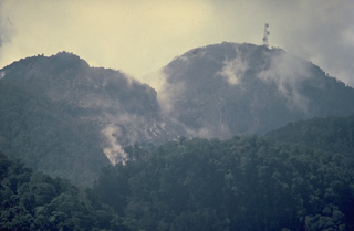 Anak Ranakah (Child of Ranakah) lava dome on the left was formed in 1987 next to the larger Ranakah lava dome on the right.
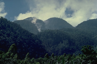 Gunung Ranakah is a group of lava domes in western Flores Island. A new dome, Anak Ranakah (Child of Ranakah), at the left in this photo, was formed in 1987 in an area without previous historical eruptive activity.
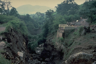 Highway bridge was destroyed by a pyroclastic flow from partial collapse of the growing lava dome of Anak Ranakah on Flores Island in 1988.
 A new lava dome, Anak Ranakah (center), formed in 1987 on the outer flanks of the poorly known Poco Leok caldera on western Flores Island. The new dome is located in an area without previous historical eruptions at the base of the large older lava dome, Gunung Ranakah. Anak Ranakah, seen here from the SW, is part of an arcuate group of lava domes extending westward from Gunung Ranakah.
There are no samples for Ranakah in the Smithsonian's NMNH Department of Mineral Sciences Rock and Ore collection.
| Copernicus Browser | The Copernicus Browser replaced the Sentinel Hub Playground browser in 2023, to provide access to Earth observation archives from the Copernicus Data Space Ecosystem, the main distribution platform for data from the EU Copernicus missions. |
| MIROVA | Middle InfraRed Observation of Volcanic Activity (MIROVA) is a near real time volcanic hot-spot detection system based on the analysis of MODIS (Moderate Resolution Imaging Spectroradiometer) data. In particular, MIROVA uses the Middle InfraRed Radiation (MIR), measured over target volcanoes, in order to detect, locate and measure the heat radiation sourced from volcanic activity. |
| MODVOLC Thermal Alerts | Using infrared satellite Moderate Resolution Imaging Spectroradiometer (MODIS) data, scientists at the Hawai'i Institute of Geophysics and Planetology, University of Hawai'i, developed an automated system called MODVOLC to map thermal hot-spots in near real time. For each MODIS image, the algorithm automatically scans each 1 km pixel within it to check for high-temperature hot-spots. When one is found the date, time, location, and intensity are recorded. MODIS looks at every square km of the Earth every 48 hours, once during the day and once during the night, and the presence of two MODIS sensors in space allows at least four hot-spot observations every two days. Each day updated global maps are compiled to display the locations of all hot spots detected in the previous 24 hours. There is a drop-down list with volcano names which allow users to 'zoom-in' and examine the distribution of hot-spots at a variety of spatial scales. |
|
WOVOdat
Single Volcano View Temporal Evolution of Unrest Side by Side Volcanoes |
WOVOdat is a database of volcanic unrest; instrumentally and visually recorded changes in seismicity, ground deformation, gas emission, and other parameters from their normal baselines. It is sponsored by the World Organization of Volcano Observatories (WOVO) and presently hosted at the Earth Observatory of Singapore.
GVMID Data on Volcano Monitoring Infrastructure The Global Volcano Monitoring Infrastructure Database GVMID, is aimed at documenting and improving capabilities of volcano monitoring from the ground and space. GVMID should provide a snapshot and baseline view of the techniques and instrumentation that are in place at various volcanoes, which can be use by volcano observatories as reference to setup new monitoring system or improving networks at a specific volcano. These data will allow identification of what monitoring gaps exist, which can be then targeted by remote sensing infrastructure and future instrument deployments. |
| Volcanic Hazard Maps | The IAVCEI Commission on Volcanic Hazards and Risk has a Volcanic Hazard Maps database designed to serve as a resource for hazard mappers (or other interested parties) to explore how common issues in hazard map development have been addressed at different volcanoes, in different countries, for different hazards, and for different intended audiences. In addition to the comprehensive, searchable Volcanic Hazard Maps Database, this website contains information about diversity of volcanic hazard maps, illustrated using examples from the database. This site is for educational purposes related to volcanic hazard maps. Hazard maps found on this website should not be used for emergency purposes. For the most recent, official hazard map for a particular volcano, please seek out the proper institutional authorities on the matter. |
| IRIS seismic stations/networks | Incorporated Research Institutions for Seismology (IRIS) Data Services map showing the location of seismic stations from all available networks (permanent or temporary) within a radius of 0.18° (about 20 km at mid-latitudes) from the given location of Ranakah. Users can customize a variety of filters and options in the left panel. Note that if there are no stations are known the map will default to show the entire world with a "No data matched request" error notice. |
| UNAVCO GPS/GNSS stations | Geodetic Data Services map from UNAVCO showing the location of GPS/GNSS stations from all available networks (permanent or temporary) within a radius of 20 km from the given location of Ranakah. Users can customize the data search based on station or network names, location, and time window. Requires Adobe Flash Player. |
| DECADE Data | The DECADE portal, still in the developmental stage, serves as an example of the proposed interoperability between The Smithsonian Institution's Global Volcanism Program, the Mapping Gas Emissions (MaGa) Database, and the EarthChem Geochemical Portal. The Deep Earth Carbon Degassing (DECADE) initiative seeks to use new and established technologies to determine accurate global fluxes of volcanic CO2 to the atmosphere, but installing CO2 monitoring networks on 20 of the world's 150 most actively degassing volcanoes. The group uses related laboratory-based studies (direct gas sampling and analysis, melt inclusions) to provide new data for direct degassing of deep earth carbon to the atmosphere. |
| Large Eruptions of Ranakah | Information about large Quaternary eruptions (VEI >= 4) is cataloged in the Large Magnitude Explosive Volcanic Eruptions (LaMEVE) database of the Volcano Global Risk Identification and Analysis Project (VOGRIPA). |
| EarthChem | EarthChem develops and maintains databases, software, and services that support the preservation, discovery, access and analysis of geochemical data, and facilitate their integration with the broad array of other available earth science parameters. EarthChem is operated by a joint team of disciplinary scientists, data scientists, data managers and information technology developers who are part of the NSF-funded data facility Integrated Earth Data Applications (IEDA). IEDA is a collaborative effort of EarthChem and the Marine Geoscience Data System (MGDS). |

