
Based on PVMBG observations, the Darwin VAAC reported that on 12 March an ash plume from Ebulobo rose to an altitude of 3 km (10,000 ft) a.s.l. (800 m above the summit) and drifted W.
Source: Darwin Volcanic Ash Advisory Centre (VAAC)
August 2013–glowing areas and hot plumes
Our last report (CSLP 19-69) discussed a summit eruption at Ebulobo stratovolcano, near the S coast of Central Flores island, that in 1969 had emitted ash and steam as well as "fire" (generally taken as incandescence but also possibly flames). CVGHM (Center for Volcanology and Mitigation of Geologic Disasters), issued a report on Ebulobo on 26 August 2013 informing readers that during August 2013, observers noted one or more hot emissions escaping from the crater. The resulting plume was of sparse consistency, white in color, under weak pressure, and it rose to 5-30 m above the peak. "Smoke" was noted.
The CVGHM report noted that on the night of 21 August 2013, observers on the volcano's N side saw incandescence at the summit area. Observations during the night of 22-23 August revealed points of glowing remained unchanged. The glowing was considered anomalous, having not been seen since 2011. The exact cause of the incandescent regions was not reported No new fissures, lava flows or pyroclastic flows were reported. The glowing later terminated as discussed in an October follow up report.
During June 2013, the system recorded the earthquakes shown in table 1.
Table 1. A summary of seismicity recorded at Ebulobo. Dashes signify cases without reported data. Extracted from the 26 August and 17 October CVGHM reports.
| Month (2013) | Shallow (VB) | Deep volcanic (VA) | Low-frequency (long period) | Local tectonic (TL) | Long distance (TJ) |
| June | -- | 12 | 1 | 18 | 47 |
| July | -- | 19 | 1 | 18 | 38 |
| August | -- | 57 | -- | 45 | 60 |
| September | 2 | 62 | -- | 27 | 67 |
| 1-16(?) October | 2 | 13 | 7 | 7 | 35 |
During 1-22 August 2013, the seismic system also recorded tremor with maximum amplitudes in the range of 0.5-15 mm.
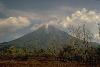
Ebulobo (figure 1) has a dedicated observation post and two seismic instruments as discussed further below.
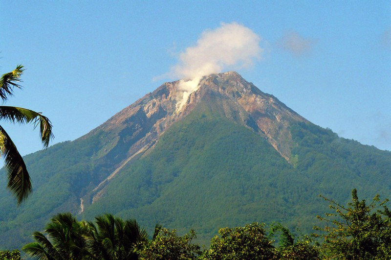 |
Figure 1. Ebulobo as seen in a photo taken 9 June 2009. Copyrighted photo by Andrzej-Muda. |
Glow diminishes and Alert Level drops (to I). During September-October white plumes rose as high as 100 m above the crater. Despite that, the glowing area had remained absent after 27 August. On 17 October CVGHM scaled back the Alert from II to I (Normal, on a scale that reaches IV).
More background. The following was extracted from CVGHM reporting.
"Ebulobo Volcano is located in the district of Nagekeo, province of Nusa Tenggara Timur. Eruptions of Ebulobo generally have consisted of lava streams that quickly formed mounds but have never so far resulted in sudden eruptive outbursts that produced a symmetrically shaped mass to the volcano. Ebulobo's eruptions have occurred between 3 and 58 years. In its historical record, its latest eruptive activity took place in 1941 and consisted of a lava stream.
"Observation of Ebulobo's activity is carried out from its monitoring post in the village of Ekowolo, sub-district of Boa Wae and is done visually and according to tremor events. The monitoring is done by means of a Type VR-60 seismograph and a Type L4C seismometer. The readings are transmitted by a telemetric system."
Information Contacts: Center for Volcanology and Mitigation of Geologic Disasters (CVGHM), Jalan Diponegoro 57, Bandung 40122, Indonesia (URL: http://www.vsi.esdm.go.id/); and theNational Agency for Disaster Management (BNPB), Gedung Graha 55 Jl. Tanah Abang II No. 57 Postal Code: 10120, Jakarta Pusat, Indonesia (URL: http://www.bnpb.go.id/).
Based on PVMBG observations, the Darwin VAAC reported that on 12 March an ash plume from Ebulobo rose to an altitude of 3 km (10,000 ft) a.s.l. (800 m above the summit) and drifted W.
Source: Darwin Volcanic Ash Advisory Centre (VAAC)
CVGHM reported that observers at Ebulobo's observation post in Ekowolo (Boa Wae District) noted that during August white plumes rose as high as 30 m. Volcanic tremor was detected starting on 10 August. At night during 21-23 August incandescence was visible on the N side of the summit (incandescence was last observed in 2011). The Alert Level was raised to 2 (on a scale of 0-4) on 23 August. Residents and tourists were not permitted within a 1.5-km-radius of the crater.
Source: Pusat Vulkanologi dan Mitigasi Bencana Geologi (PVMBG, also known as CVGHM)
Reports are organized chronologically and indexed below by Month/Year (Publication Volume:Number), and include a one-line summary. Click on the index link or scroll down to read the reports.
Summit eruption with "fire and steam" and ash
Card 0432 (28 February 1969) Summit eruption with "fire and steam" and ash
"Mount Ebu Lobo . . . has begun activity, with fire and steam on summit and ash eruption."
Information Contacts: Djajadi Volcanological Service via the American Embassy, Djarkata, Indonesia.
August 2013–glowing areas and hot plumes
Our last report (CSLP 19-69) discussed a summit eruption at Ebulobo stratovolcano, near the S coast of Central Flores island, that in 1969 had emitted ash and steam as well as "fire" (generally taken as incandescence but also possibly flames). CVGHM (Center for Volcanology and Mitigation of Geologic Disasters), issued a report on Ebulobo on 26 August 2013 informing readers that during August 2013, observers noted one or more hot emissions escaping from the crater. The resulting plume was of sparse consistency, white in color, under weak pressure, and it rose to 5-30 m above the peak. "Smoke" was noted.
The CVGHM report noted that on the night of 21 August 2013, observers on the volcano's N side saw incandescence at the summit area. Observations during the night of 22-23 August revealed points of glowing remained unchanged. The glowing was considered anomalous, having not been seen since 2011. The exact cause of the incandescent regions was not reported No new fissures, lava flows or pyroclastic flows were reported. The glowing later terminated as discussed in an October follow up report.
During June 2013, the system recorded the earthquakes shown in table 1.
Table 1. A summary of seismicity recorded at Ebulobo. Dashes signify cases without reported data. Extracted from the 26 August and 17 October CVGHM reports.
| Month (2013) | Shallow (VB) | Deep volcanic (VA) | Low-frequency (long period) | Local tectonic (TL) | Long distance (TJ) |
| June | -- | 12 | 1 | 18 | 47 |
| July | -- | 19 | 1 | 18 | 38 |
| August | -- | 57 | -- | 45 | 60 |
| September | 2 | 62 | -- | 27 | 67 |
| 1-16(?) October | 2 | 13 | 7 | 7 | 35 |
During 1-22 August 2013, the seismic system also recorded tremor with maximum amplitudes in the range of 0.5-15 mm.
Ebulobo (figure 1) has a dedicated observation post and two seismic instruments as discussed further below.
|
Figure 1. Ebulobo as seen in a photo taken 9 June 2009. Copyrighted photo by Andrzej-Muda. |
Glow diminishes and Alert Level drops (to I). During September-October white plumes rose as high as 100 m above the crater. Despite that, the glowing area had remained absent after 27 August. On 17 October CVGHM scaled back the Alert from II to I (Normal, on a scale that reaches IV).
More background. The following was extracted from CVGHM reporting.
"Ebulobo Volcano is located in the district of Nagekeo, province of Nusa Tenggara Timur. Eruptions of Ebulobo generally have consisted of lava streams that quickly formed mounds but have never so far resulted in sudden eruptive outbursts that produced a symmetrically shaped mass to the volcano. Ebulobo's eruptions have occurred between 3 and 58 years. In its historical record, its latest eruptive activity took place in 1941 and consisted of a lava stream.
"Observation of Ebulobo's activity is carried out from its monitoring post in the village of Ekowolo, sub-district of Boa Wae and is done visually and according to tremor events. The monitoring is done by means of a Type VR-60 seismograph and a Type L4C seismometer. The readings are transmitted by a telemetric system."
Information Contacts: Center for Volcanology and Mitigation of Geologic Disasters (CVGHM), Jalan Diponegoro 57, Bandung 40122, Indonesia (URL: http://www.vsi.esdm.go.id/); and theNational Agency for Disaster Management (BNPB), Gedung Graha 55 Jl. Tanah Abang II No. 57 Postal Code: 10120, Jakarta Pusat, Indonesia (URL: http://www.bnpb.go.id/).
|
|
||||||||||||||||||||||||||
There is data available for 7 confirmed eruptive periods.
[ 2017 Mar 12 - 2017 Mar 12 ] Uncertain Eruption
| Episode 1 | Uncertain | ||||
|---|---|---|---|---|
| 2017 Mar 12 - 2017 Mar 12 | Evidence from Observations: Reported | |||
1969 Feb 27 Confirmed Eruption (Explosive / Effusive) VEI: 2 (?)
| Episode 1 | Eruption (Explosive / Effusive) | |||||||||||||||||||
|---|---|---|---|---|---|---|---|---|---|---|---|---|---|---|---|---|---|---|---|
| 1969 Feb 27 - Unknown | Evidence from Observations: Reported | ||||||||||||||||||
|
List of 2 Events for Episode 1
|
|||||||||||||||||||
1941 Aug 23 ± 8 days Confirmed Eruption (Explosive / Effusive) VEI: 0 (?)
| Episode 1 | Eruption (Explosive / Effusive) | |||||||||||||||||||
|---|---|---|---|---|---|---|---|---|---|---|---|---|---|---|---|---|---|---|---|
| 1941 Aug 23 ± 8 days - Unknown | Evidence from Observations: Reported | ||||||||||||||||||
|
List of 2 Events for Episode 1
|
|||||||||||||||||||
1938 May - 1938 Jun Confirmed Eruption (Explosive / Effusive)
| Episode 1 | Eruption (Explosive / Effusive) | ||||
|---|---|---|---|---|
| 1938 May - 1938 Jun | Evidence from Observations: Reported | |||
1924 Nov Confirmed Eruption (Explosive / Effusive) VEI: 2
| Episode 1 | Eruption (Explosive / Effusive) | ||||||||||||||||||||||||
|---|---|---|---|---|---|---|---|---|---|---|---|---|---|---|---|---|---|---|---|---|---|---|---|---|
| 1924 Nov - Unknown | Evidence from Observations: Reported | |||||||||||||||||||||||
|
List of 3 Events for Episode 1
|
||||||||||||||||||||||||
1910 Apr 10 Confirmed Eruption (Explosive / Effusive) VEI: 2
| Episode 1 | Eruption (Explosive / Effusive) | |||||||||||||||||||
|---|---|---|---|---|---|---|---|---|---|---|---|---|---|---|---|---|---|---|---|
| 1910 Apr 10 - Unknown | Evidence from Observations: Reported | ||||||||||||||||||
|
List of 2 Events for Episode 1
|
|||||||||||||||||||
1888 Confirmed Eruption (Explosive / Effusive) VEI: 2
| Episode 1 | Eruption (Explosive / Effusive) | |||||||||||||||||||
|---|---|---|---|---|---|---|---|---|---|---|---|---|---|---|---|---|---|---|---|
| 1888 - Unknown | Evidence from Observations: Reported | ||||||||||||||||||
|
List of 2 Events for Episode 1
|
|||||||||||||||||||
1830 Confirmed Eruption (Explosive / Effusive) VEI: 2
| Episode 1 | Eruption (Explosive / Effusive) | ||||||||||||||||||||||||
|---|---|---|---|---|---|---|---|---|---|---|---|---|---|---|---|---|---|---|---|---|---|---|---|---|
| 1830 - Unknown | Evidence from Observations: Reported | |||||||||||||||||||||||
|
List of 3 Events for Episode 1
|
||||||||||||||||||||||||
This compilation of synonyms and subsidiary features may not be comprehensive. Features are organized into four major categories: Cones, Craters, Domes, and Thermal Features. Synonyms of features appear indented below the primary name. In some cases additional feature type, elevation, or location details are provided.
Synonyms |
| Keo Peak | Amboelombo | Ebu Lobo | Amburembu | Ebo Lobo | Eboeloba | Amburombu | Amboloko |
 Ebulobo (also known as Amburombu or Keo Peak) is a symmetrical 2124-m-high stratovolcano in central Flores Island. A flat-topped lava dome fills the 250-m-wide summit crater. The first historical eruption of Ebulobo in 1830 produced a lava flow down the north flank.
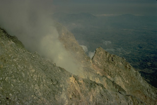 A fumarole steams on the flank of the summit lava dome of Ebulobo volcano in central Flores Island. The summit crater of Ebulobo is partially filled by the lava dome and is breached on three sides.
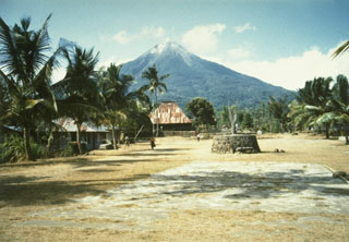 Ebulobo above the village of Boa Wae, located below the NW flank of the volcano. Ebulobo is located in central Flores Island and has a summit lava dome. Historical eruptions, recorded since 1830, include lava emission down the N flank and explosive eruptions from the summit crater.
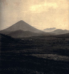 Gunung Ebulobo rises above highlands in south-central Flores in this view from the south. Dominantly explosive eruptions have been recorded since the 19th century.
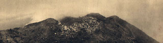 A lava dome occupies the summit of Ebulobo volcano, also known as Keo Peak, as seen here from the south in 1929.
There are no samples for Ebulobo in the Smithsonian's NMNH Department of Mineral Sciences Rock and Ore collection.
| Copernicus Browser | The Copernicus Browser replaced the Sentinel Hub Playground browser in 2023, to provide access to Earth observation archives from the Copernicus Data Space Ecosystem, the main distribution platform for data from the EU Copernicus missions. |
| MIROVA | Middle InfraRed Observation of Volcanic Activity (MIROVA) is a near real time volcanic hot-spot detection system based on the analysis of MODIS (Moderate Resolution Imaging Spectroradiometer) data. In particular, MIROVA uses the Middle InfraRed Radiation (MIR), measured over target volcanoes, in order to detect, locate and measure the heat radiation sourced from volcanic activity. |
| MODVOLC Thermal Alerts | Using infrared satellite Moderate Resolution Imaging Spectroradiometer (MODIS) data, scientists at the Hawai'i Institute of Geophysics and Planetology, University of Hawai'i, developed an automated system called MODVOLC to map thermal hot-spots in near real time. For each MODIS image, the algorithm automatically scans each 1 km pixel within it to check for high-temperature hot-spots. When one is found the date, time, location, and intensity are recorded. MODIS looks at every square km of the Earth every 48 hours, once during the day and once during the night, and the presence of two MODIS sensors in space allows at least four hot-spot observations every two days. Each day updated global maps are compiled to display the locations of all hot spots detected in the previous 24 hours. There is a drop-down list with volcano names which allow users to 'zoom-in' and examine the distribution of hot-spots at a variety of spatial scales. |
|
WOVOdat
Single Volcano View Temporal Evolution of Unrest Side by Side Volcanoes |
WOVOdat is a database of volcanic unrest; instrumentally and visually recorded changes in seismicity, ground deformation, gas emission, and other parameters from their normal baselines. It is sponsored by the World Organization of Volcano Observatories (WOVO) and presently hosted at the Earth Observatory of Singapore.
GVMID Data on Volcano Monitoring Infrastructure The Global Volcano Monitoring Infrastructure Database GVMID, is aimed at documenting and improving capabilities of volcano monitoring from the ground and space. GVMID should provide a snapshot and baseline view of the techniques and instrumentation that are in place at various volcanoes, which can be use by volcano observatories as reference to setup new monitoring system or improving networks at a specific volcano. These data will allow identification of what monitoring gaps exist, which can be then targeted by remote sensing infrastructure and future instrument deployments. |
| Volcanic Hazard Maps | The IAVCEI Commission on Volcanic Hazards and Risk has a Volcanic Hazard Maps database designed to serve as a resource for hazard mappers (or other interested parties) to explore how common issues in hazard map development have been addressed at different volcanoes, in different countries, for different hazards, and for different intended audiences. In addition to the comprehensive, searchable Volcanic Hazard Maps Database, this website contains information about diversity of volcanic hazard maps, illustrated using examples from the database. This site is for educational purposes related to volcanic hazard maps. Hazard maps found on this website should not be used for emergency purposes. For the most recent, official hazard map for a particular volcano, please seek out the proper institutional authorities on the matter. |
| IRIS seismic stations/networks | Incorporated Research Institutions for Seismology (IRIS) Data Services map showing the location of seismic stations from all available networks (permanent or temporary) within a radius of 0.18° (about 20 km at mid-latitudes) from the given location of Ebulobo. Users can customize a variety of filters and options in the left panel. Note that if there are no stations are known the map will default to show the entire world with a "No data matched request" error notice. |
| UNAVCO GPS/GNSS stations | Geodetic Data Services map from UNAVCO showing the location of GPS/GNSS stations from all available networks (permanent or temporary) within a radius of 20 km from the given location of Ebulobo. Users can customize the data search based on station or network names, location, and time window. Requires Adobe Flash Player. |
| DECADE Data | The DECADE portal, still in the developmental stage, serves as an example of the proposed interoperability between The Smithsonian Institution's Global Volcanism Program, the Mapping Gas Emissions (MaGa) Database, and the EarthChem Geochemical Portal. The Deep Earth Carbon Degassing (DECADE) initiative seeks to use new and established technologies to determine accurate global fluxes of volcanic CO2 to the atmosphere, but installing CO2 monitoring networks on 20 of the world's 150 most actively degassing volcanoes. The group uses related laboratory-based studies (direct gas sampling and analysis, melt inclusions) to provide new data for direct degassing of deep earth carbon to the atmosphere. |
| Large Eruptions of Ebulobo | Information about large Quaternary eruptions (VEI >= 4) is cataloged in the Large Magnitude Explosive Volcanic Eruptions (LaMEVE) database of the Volcano Global Risk Identification and Analysis Project (VOGRIPA). |
| EarthChem | EarthChem develops and maintains databases, software, and services that support the preservation, discovery, access and analysis of geochemical data, and facilitate their integration with the broad array of other available earth science parameters. EarthChem is operated by a joint team of disciplinary scientists, data scientists, data managers and information technology developers who are part of the NSF-funded data facility Integrated Earth Data Applications (IEDA). IEDA is a collaborative effort of EarthChem and the Marine Geoscience Data System (MGDS). |

