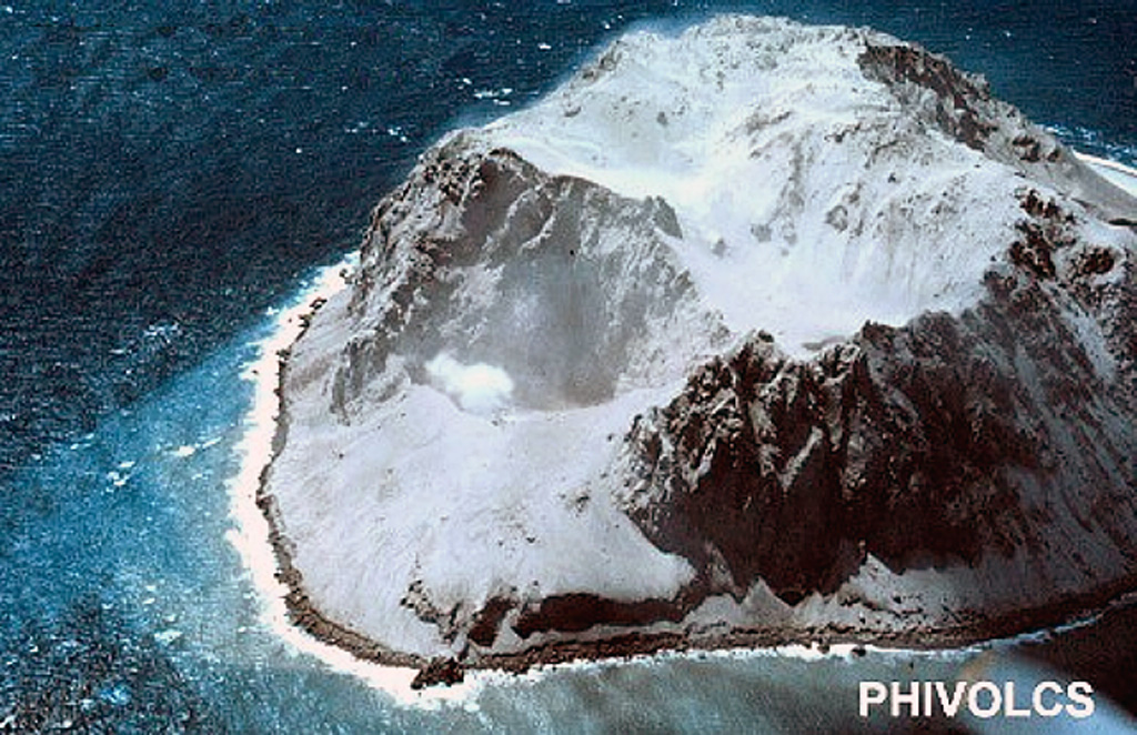
Ashfall observed in early January 1978 over the entire island
[The following report of observations during 6-9 January 1978 was published in the Bulletin of Volcanic Eruptions (1980). "Aerial observation conducted over Didicas volcano revealed that the whole volcano island was covered fresh volcanic ashes, however, no lava extrusion and usual agitation of the sea water in the immediate vicinity was noticed. Observation also disclosed that the three eruptive craters of the volcano located in the NNE portion of the island have no steaming activity nor bubbling activity."]
Reference. Volcanological Society of Japan, 1980, Bulletin of volcanic eruptions no. 18: Annual report of the world volcanic eruptions in 1978: International Association of Volcanology and Chemistry of the Earth's Interior, IUGG, p. 27.
Information Contacts: G.A. Andal, Commission on Volcanology, Quezon, Philippines.
The Global Volcanism Program has no Weekly Reports available for Didicas.
Reports are organized chronologically and indexed below by Month/Year (Publication Volume:Number), and include a one-line summary. Click on the index link or scroll down to read the reports.
New crater filled with boiling water; ashfall on island
Card 0476 (28 March 1969) New crater filled with boiling water; ashfall on island
"Air reconaissance Didicas Volcano on Babuyan Island 27 March reported eruption. Present activity at northern portion of island formed crater measuring 20 m at bottom, filled with muddy boiling water. Steam clouds without force rising few hundred feet above crater rim. Northern half of island covered by thick whitish-gray ash which also discolors sea fronting eruption site. Commission on Volcanology believes further ash eruption likely to be followed by lava extrusion."
Information Contacts: American Embassy, Manila, Philippines.
Ashfall near the crater, rock ejections and steaming; three deaths
Card 0484 (01 April 1969) Three persons killed while fishing near the volcano
Three persons were swallowed up while fishing near San Vicente, Sta. Ana, Cagayan, yesterday when Didicas Volcano at Didicas Island erupted, according to reports reaching the Commission on Volcanology in Manila from the Cagayan PC.
Arturo Alcaraz, chief volcanologist at the Commission on Volcanology, said that Didicas Volcano, which lies 100 km N of Aparri in Cagayan (figure 1), was a submarine volcano until 1952 when it erupted and formed an island one mile and a half in diameter and about 800 feet high above sea level.
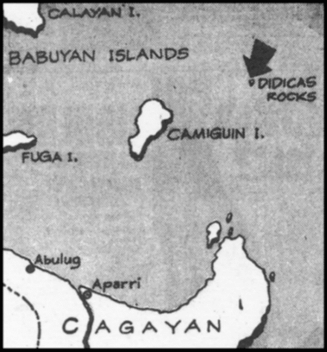 |
Figure 1. Sketch map showing the location of Didicas in the Babuyan Islands north of Luzon, Philippines. |
Card 0487 (03 April 1969) Ashfall evident around active crater; white steam rising
Commission on Volcanology report after air reconaissance on 28 March, Didicas indicates activity limited to northern portion of island. No ash ejection observed but recent ash falls evident around active crater. White steam rising. Commission on Volcanology expects continued intermittent ash eruption with possible future lava extrusion. Present activity constitutes no threat to inhabitants.
Card 0490 (08 April 1969) Minor fumarolic activity and steaming
"COMVOL air reconnaissance . . . indicated . . . Didicas activity waned from last week's eruption. Newly formed crater exhibiting small fumarolic activity at single point on inner slope. Steaming detected from higher area close to central portion volcano indicating possible activity shift to island's center."
Card 0506 (17 April 1969) Overflight on 29 March reveals steam rising from crater
Activity . . . has been limited to ash and rock ejection. The volcano's activity is still in its initial stage and a major eruption is possible. Nazario Vasquez made this observation on board this Herald plane which flew over the volcano at 0815 [on 29 March].
The spasmic ejections consisted of rocks which the volcano emits through a vent opened during the earlier stages of its present activity. Signs that the volcano was building up pressure were manifested by continued rise and extrusion of ashes and steam from a crater on the northern side of the islet. If the activity of the volcano continues, Nazario said, there would probably follow an extrusion of lava.
Commission of Volcanology records showed Didicas has erupted violently in the past. "Spines" have formed some 14 nautical miles off Camiguin Island north of Cagayan about 1856. These spines were above-the-sea-level expressions of a submarine volcano. Subsequent eruptions formed these rocks into an islet now known as Didicas. A volcano eruption in 1952 caused the formation of an islet 800 feet high and about a mile in diameter.
During the air reconnaissance survey, white steam was observed rising from the mouth of the crater in the northern portion. Nazario said there was a possibility of an undersea crater which could give vent to steam and lava.
Card 0514 (24 April 1969) Thick smoke observed on 31 March
The following message from the Calayan Weather Station was relayed by the Weather Bureau. "Didicas volcano seen emitting thick smoke yesterday (31 March) visible eastern part Calayan. People worried. Please advise immediately -Signed Singson."
The following evalution of the Didicas activity was furnished the Weather Bureau for transmittal to Calayan. "Commission on Volcanology believes Didicas activity to continue for some time yet. Further ash eruptions expected, but will not adversely affect Calayan or nearby islands. Allay people's fear also concerning tidal waves. Their occurrence considered only a remote possibility and even then their effects likely will be negligible to settlements of Babuyan Islands and northern Luzon."
Card 0515 (24 April 1969) Activity has waned from previous week
The current eruption of Didicas Volcano was observed to have waned from that of last week's recon findings. The activity in the newly formed explosion crater at the northern end of the island volcano has quited down to just small fumarolic activity at a point on its inner slope. However, steaming was detected from a higher area close to the central portion of the volcano. This may indicate that the point of activity can be shifting towards the center of the island.
Information Contacts:
Card 0484 (01 April 1969) Manila Times, Manila, Philippines (27 March 1969).
Card 0487 (03 April 1969) American Embassy, Manila, Philippines.
Card 0490 (08 April 1969) American Embassy, Manila, Philippines.
Card 0506 (17 April 1969) Rogelio Razon, The Philippines Herald, Manila, Philippines (29 March 1969).
Card 0514 (24 April 1969) Arturo Alcaraz, Commission on Volcanology, Manila, Philippines.
Card 0515 (24 April 1969) Arturo Alcaraz, Commission on Volcanology, Manila, Philippines.
Ashfall observed in early January 1978 over the entire island
[The following report of observations during 6-9 January 1978 was published in the Bulletin of Volcanic Eruptions (1980). "Aerial observation conducted over Didicas volcano revealed that the whole volcano island was covered fresh volcanic ashes, however, no lava extrusion and usual agitation of the sea water in the immediate vicinity was noticed. Observation also disclosed that the three eruptive craters of the volcano located in the NNE portion of the island have no steaming activity nor bubbling activity."]
Reference. Volcanological Society of Japan, 1980, Bulletin of volcanic eruptions no. 18: Annual report of the world volcanic eruptions in 1978: International Association of Volcanology and Chemistry of the Earth's Interior, IUGG, p. 27.
Information Contacts: G.A. Andal, Commission on Volcanology, Quezon, Philippines.
|
|
||||||||||||||||||||||||||
There is data available for 5 confirmed eruptive periods.
1978 Jan 6 - 1978 Jan 9 Confirmed Eruption (Explosive / Effusive) VEI: 2
| Episode 1 | Eruption (Explosive / Effusive) | NNE side | ||||||||||||||||||||||||||||
|---|---|---|---|---|---|---|---|---|---|---|---|---|---|---|---|---|---|---|---|---|---|---|---|---|---|---|---|---|---|
| 1978 Jan 6 - 1978 Jan 9 | Evidence from Observations: Reported | ||||||||||||||||||||||||||||
|
List of 4 Events for Episode 1 at NNE side
|
|||||||||||||||||||||||||||||
1969 Mar 21 - 1969 Jun 16 ± 15 days Confirmed Eruption (Explosive / Effusive) VEI: 2
| Episode 1 | Eruption (Explosive / Effusive) | North side | |||||||||||||||||||||||||||||||||
|---|---|---|---|---|---|---|---|---|---|---|---|---|---|---|---|---|---|---|---|---|---|---|---|---|---|---|---|---|---|---|---|---|---|---|
| 1969 Mar 21 - 1969 Jun 16 ± 15 days | Evidence from Observations: Reported | |||||||||||||||||||||||||||||||||
|
List of 5 Events for Episode 1 at North side
|
||||||||||||||||||||||||||||||||||
1952 Mar 16 (on or before) - 1953 Jul 2 (?) ± 182 days Confirmed Eruption (Explosive / Effusive) VEI: 2
| Episode 1 | Eruption (Explosive / Effusive) | |||||||||||||||||||||||||||||||||||||||||||||||||
|---|---|---|---|---|---|---|---|---|---|---|---|---|---|---|---|---|---|---|---|---|---|---|---|---|---|---|---|---|---|---|---|---|---|---|---|---|---|---|---|---|---|---|---|---|---|---|---|---|---|
| 1952 Mar 16 (on or before) - 1953 Jul 2 (?) ± 182 days | Evidence from Observations: Reported | ||||||||||||||||||||||||||||||||||||||||||||||||
|
List of 8 Events for Episode 1
|
|||||||||||||||||||||||||||||||||||||||||||||||||
1900 Confirmed Eruption (Explosive / Effusive) VEI: 0 (?)
| Episode 1 | Eruption (Explosive / Effusive) | |||||||||||||||||||
|---|---|---|---|---|---|---|---|---|---|---|---|---|---|---|---|---|---|---|---|
| 1900 - Unknown | Evidence from Observations: Reported | ||||||||||||||||||
|
List of 2 Events for Episode 1
|
|||||||||||||||||||
1856 Sep 30 ± 30 days - 1860 Oct (?) Confirmed Eruption (Submarine) VEI: 2
| Episode 1 | Eruption (Submarine) | ||||||||||||||||||||||||||||||||||
|---|---|---|---|---|---|---|---|---|---|---|---|---|---|---|---|---|---|---|---|---|---|---|---|---|---|---|---|---|---|---|---|---|---|---|
| 1856 Sep 30 ± 30 days - 1860 Oct (?) | Evidence from Observations: Reported | |||||||||||||||||||||||||||||||||
| An eruption began in September or October 1856. Activity built an island that was later eroded away. | ||||||||||||||||||||||||||||||||||
|
List of 5 Events for Episode 1
|
||||||||||||||||||||||||||||||||||
[ 1773 Oct ] Uncertain Eruption
| Episode 1 | Uncertain | |||||||||||||||||||
|---|---|---|---|---|---|---|---|---|---|---|---|---|---|---|---|---|---|---|---|
| 1773 Oct - Unknown | Evidence from Observations: Reported | ||||||||||||||||||
| Neumann van Padang (1953, citing various older sources) listed a possible submarine eruption in October 1773, along with a similar separate 1773 eruption at a location near Ibugos Island, 140 km NNW. However, Maso (1927) listed an October 1773 earthquake described as "violent" felt in W Luzon, Zambales, Cavite, and Bataan provinces. PHIVOLCS (2004) listed a phreatic explosion in October 1773. | |||||||||||||||||||
|
List of 2 Events for Episode 1
|
|||||||||||||||||||
This compilation of synonyms and subsidiary features may not be comprehensive. Features are organized into four major categories: Cones, Craters, Domes, and Thermal Features. Synonyms of features appear indented below the primary name. In some cases additional feature type, elevation, or location details are provided.
Synonyms |
| Didica | Dedica | Didikas Rocks | Dedicas |
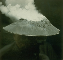 Didicas volcano forms a small, 1.4-km wide island in the Philippines, north of Luzon Island. Prior to 1952, when a lava dome formed, the volcano was submarine. A 5-acre island was first seen on March 16; this June 17 view shows the new steaming lava dome. Submarine eruptions were reported in 1773, during 1856-1860 (when an ephemeral island was formed), and around 1900.
  Didicas volcano, 22 km NE of Camiguin Island, was a submarine volcano prior to becoming a permanent island in 1952. The first recorded submarine eruption of Didicas was in 1773. A 400-m-wide crater formed during the 1952 eruption, and two eruptions have occurred since then at a crater on the northern side of the island.
There are no samples for Didicas in the Smithsonian's NMNH Department of Mineral Sciences Rock and Ore collection.
| Copernicus Browser | The Copernicus Browser replaced the Sentinel Hub Playground browser in 2023, to provide access to Earth observation archives from the Copernicus Data Space Ecosystem, the main distribution platform for data from the EU Copernicus missions. |
| MIROVA | Middle InfraRed Observation of Volcanic Activity (MIROVA) is a near real time volcanic hot-spot detection system based on the analysis of MODIS (Moderate Resolution Imaging Spectroradiometer) data. In particular, MIROVA uses the Middle InfraRed Radiation (MIR), measured over target volcanoes, in order to detect, locate and measure the heat radiation sourced from volcanic activity. |
| MODVOLC Thermal Alerts | Using infrared satellite Moderate Resolution Imaging Spectroradiometer (MODIS) data, scientists at the Hawai'i Institute of Geophysics and Planetology, University of Hawai'i, developed an automated system called MODVOLC to map thermal hot-spots in near real time. For each MODIS image, the algorithm automatically scans each 1 km pixel within it to check for high-temperature hot-spots. When one is found the date, time, location, and intensity are recorded. MODIS looks at every square km of the Earth every 48 hours, once during the day and once during the night, and the presence of two MODIS sensors in space allows at least four hot-spot observations every two days. Each day updated global maps are compiled to display the locations of all hot spots detected in the previous 24 hours. There is a drop-down list with volcano names which allow users to 'zoom-in' and examine the distribution of hot-spots at a variety of spatial scales. |
|
WOVOdat
Single Volcano View Temporal Evolution of Unrest Side by Side Volcanoes |
WOVOdat is a database of volcanic unrest; instrumentally and visually recorded changes in seismicity, ground deformation, gas emission, and other parameters from their normal baselines. It is sponsored by the World Organization of Volcano Observatories (WOVO) and presently hosted at the Earth Observatory of Singapore.
GVMID Data on Volcano Monitoring Infrastructure The Global Volcano Monitoring Infrastructure Database GVMID, is aimed at documenting and improving capabilities of volcano monitoring from the ground and space. GVMID should provide a snapshot and baseline view of the techniques and instrumentation that are in place at various volcanoes, which can be use by volcano observatories as reference to setup new monitoring system or improving networks at a specific volcano. These data will allow identification of what monitoring gaps exist, which can be then targeted by remote sensing infrastructure and future instrument deployments. |
| Volcanic Hazard Maps | The IAVCEI Commission on Volcanic Hazards and Risk has a Volcanic Hazard Maps database designed to serve as a resource for hazard mappers (or other interested parties) to explore how common issues in hazard map development have been addressed at different volcanoes, in different countries, for different hazards, and for different intended audiences. In addition to the comprehensive, searchable Volcanic Hazard Maps Database, this website contains information about diversity of volcanic hazard maps, illustrated using examples from the database. This site is for educational purposes related to volcanic hazard maps. Hazard maps found on this website should not be used for emergency purposes. For the most recent, official hazard map for a particular volcano, please seek out the proper institutional authorities on the matter. |
| IRIS seismic stations/networks | Incorporated Research Institutions for Seismology (IRIS) Data Services map showing the location of seismic stations from all available networks (permanent or temporary) within a radius of 0.18° (about 20 km at mid-latitudes) from the given location of Didicas. Users can customize a variety of filters and options in the left panel. Note that if there are no stations are known the map will default to show the entire world with a "No data matched request" error notice. |
| UNAVCO GPS/GNSS stations | Geodetic Data Services map from UNAVCO showing the location of GPS/GNSS stations from all available networks (permanent or temporary) within a radius of 20 km from the given location of Didicas. Users can customize the data search based on station or network names, location, and time window. Requires Adobe Flash Player. |
| DECADE Data | The DECADE portal, still in the developmental stage, serves as an example of the proposed interoperability between The Smithsonian Institution's Global Volcanism Program, the Mapping Gas Emissions (MaGa) Database, and the EarthChem Geochemical Portal. The Deep Earth Carbon Degassing (DECADE) initiative seeks to use new and established technologies to determine accurate global fluxes of volcanic CO2 to the atmosphere, but installing CO2 monitoring networks on 20 of the world's 150 most actively degassing volcanoes. The group uses related laboratory-based studies (direct gas sampling and analysis, melt inclusions) to provide new data for direct degassing of deep earth carbon to the atmosphere. |
| Large Eruptions of Didicas | Information about large Quaternary eruptions (VEI >= 4) is cataloged in the Large Magnitude Explosive Volcanic Eruptions (LaMEVE) database of the Volcano Global Risk Identification and Analysis Project (VOGRIPA). |
| EarthChem | EarthChem develops and maintains databases, software, and services that support the preservation, discovery, access and analysis of geochemical data, and facilitate their integration with the broad array of other available earth science parameters. EarthChem is operated by a joint team of disciplinary scientists, data scientists, data managers and information technology developers who are part of the NSF-funded data facility Integrated Earth Data Applications (IEDA). IEDA is a collaborative effort of EarthChem and the Marine Geoscience Data System (MGDS). |

