Four hikers killed in a gas-filled depression
Four hikers died from inhalation of volcanic gases after being exposed to fumes on the floor of Numano-taira (also called Numano-daira) crater on 15 September. The hikers were part of a group of 14 Tokyo barbers who became disoriented in foggy conditions and departed from a trail. After three hikers fell at the head of a small valley in the S rim of the crater, another member of the party attempted a rescue but also fell to the floor of the crater, where deadly gases had accumulated due to light northerly winds. Other hikers in the area noticed a strong sulfuric odor, warned others of the danger, and climbed to higher ground. Signs warning of the volcanic gas hazard were posted at the trail head.
According to scientists at the Kusatsu-Shirane Volcano Observatory, fumarolic gas from the SW part of the crater is composed of 0.5% SO2, 60-65% H2S and 33-37% CO2. Gas collected in July from a mud pond on the crater floor contained 41% H2S and 56% CO2. The most likely reason for the fatalities was the presence of the H2S and the calm wind conditions that allowed gases to accumulate in the lowest part of the crater.
The Japan Meteorological Agency (JMA) released a report on recent activity at the volcano including a volcanic gas advisory on 15 September. The report details 5 volcanic earthquakes that occurred in August and increased mud spouting and fumarolic activity. Other activity reported at the crater included mud effusion at three pits on the crater floor in July and August 1996 as well as a very small-scale phreatic explosion on 1 September 1996 (BGVN 21:08).
Information Contacts: Jun-ichi Hirabayashi, Kusatsu-Shirane Volcano Observatory, Tokyo Institute of Technology, Kusatsu, Agatsuma-gun, Gunma 377-17, Japan; Noritake Nishide, Sendai District Meteorological Observatory, Japan Meteorological Agency (JMA), 1-3- 15 Gorin, Miyagino-ku, Sendai 983, Japan; Yoshihisa Kawanabe, Volcanology Section, Environmental Geology Department, Geological Survey of Japan, 1-1-3, Higashi, Tsukuba, Ibaraki, 305 Japan; Tatsuro Chiba, Dept of Disaster Prevention, Asia Air Survey Co., 4-2-18 Shinjuku, Shinjuku-ku, Tokyo 160, Japan (URL: http://www.ajiko.co.jp/en/); Volcano Research Center, University of Tokyo, Yayoi, Bunkyo-ku, Tokyo 113, Japan (URL: http://www.eri.u-tokyo.ac.jp/VRC/index_E.html).
The Global Volcanism Program has no Weekly Reports available for Adatarayama.
Reports are organized chronologically and indexed below by Month/Year (Publication Volume:Number), and include a one-line summary. Click on the index link or scroll down to read the reports.
First tremor since 1965
During 27 October, volcanic tremor of about 3-minutes duration was recorded at a site 4.8 km NE of Adatara's summit (station A). This was the first case of tremor since the local observatory began observations in 1965.
Information Contacts: Volcanological Division, Seismological and Volcanological Department, Japan Meteorological Agency (JMA), 1-3-4 Ote-machi, Chiyoda-ku, Tokyo 100 Japan.
Volcanic tremor detected on four days in April
On 12, 15, 25, and 26 April, small-amplitude volcanic tremors were detected. Volcanic tremor was previously recorded on 27 October 1995 (BGVN 20:10), the first such occurrence since observations began in 1965.
Information Contacts: Volcanological Division, Seismological and Volcanological Department, Japan Meteorological Agency (JMA), 1-3-4 Ote-machi, Chiyoda-ku, Tokyo 100 Japan.
A small aseismic, phreatic eruption on 1 September
A small-scale phreatic eruption suddenly took place on 1 September. On 4 September a survey team from the Japan Meteorological Agency (JMA) verified that mud was sprayed ~100 m from small pits at the summit area (Numanotaira). Mud crusts and mud flows were found around three pits, and a strong odor of sulfurous gas was noted. Some mountaineers witnessed and photographed this eruption. Although both Tohoku University and JMA monitor seismicity of the volcano, no seismic activity was recorded just prior to or during the eruption. After the eruption, there was also no evidence implying an increase in seismicity. This has been the first observation of eruptive phenomena since monitoring began in 1965. Volcanic tremor was last reported in April (BGVN 21:04). The JMA seismic net also recorded volcanic tremor once in June.
A survey by Tatsuro Chiba of Asia Air Survey Co. Ltd. indicated that mud effusion on the Numanotaira crater floor also occurred in July and August of this year. The Asahi TV Company took pictures of mud bubbling in one of the pits during mid-August. According to Tatsuro Chiba, two of three pits in the crater already had existed before 1 September and the third pit might have been formed during the 1 September eruption.
Information Contacts: Volcanological Division, Japan Meteorological Agency (JMA), 1-3-4 Ote-machi, Chiyoda-ku, Tokyo 100, Japan; Volcano Research Center, Earthquake Research Institute (ERI), University of Tokyo, Yayoi 1-1-1, Bunkyo-ku, Tokyo 113, Japan (URL: http://www.eri.u-tokyo.ac.jp/VRC/index_E.html).
Four hikers killed in a gas-filled depression
Four hikers died from inhalation of volcanic gases after being exposed to fumes on the floor of Numano-taira (also called Numano-daira) crater on 15 September. The hikers were part of a group of 14 Tokyo barbers who became disoriented in foggy conditions and departed from a trail. After three hikers fell at the head of a small valley in the S rim of the crater, another member of the party attempted a rescue but also fell to the floor of the crater, where deadly gases had accumulated due to light northerly winds. Other hikers in the area noticed a strong sulfuric odor, warned others of the danger, and climbed to higher ground. Signs warning of the volcanic gas hazard were posted at the trail head.
According to scientists at the Kusatsu-Shirane Volcano Observatory, fumarolic gas from the SW part of the crater is composed of 0.5% SO2, 60-65% H2S and 33-37% CO2. Gas collected in July from a mud pond on the crater floor contained 41% H2S and 56% CO2. The most likely reason for the fatalities was the presence of the H2S and the calm wind conditions that allowed gases to accumulate in the lowest part of the crater.
The Japan Meteorological Agency (JMA) released a report on recent activity at the volcano including a volcanic gas advisory on 15 September. The report details 5 volcanic earthquakes that occurred in August and increased mud spouting and fumarolic activity. Other activity reported at the crater included mud effusion at three pits on the crater floor in July and August 1996 as well as a very small-scale phreatic explosion on 1 September 1996 (BGVN 21:08).
Information Contacts: Jun-ichi Hirabayashi, Kusatsu-Shirane Volcano Observatory, Tokyo Institute of Technology, Kusatsu, Agatsuma-gun, Gunma 377-17, Japan; Noritake Nishide, Sendai District Meteorological Observatory, Japan Meteorological Agency (JMA), 1-3- 15 Gorin, Miyagino-ku, Sendai 983, Japan; Yoshihisa Kawanabe, Volcanology Section, Environmental Geology Department, Geological Survey of Japan, 1-1-3, Higashi, Tsukuba, Ibaraki, 305 Japan; Tatsuro Chiba, Dept of Disaster Prevention, Asia Air Survey Co., 4-2-18 Shinjuku, Shinjuku-ku, Tokyo 160, Japan (URL: http://www.ajiko.co.jp/en/); Volcano Research Center, University of Tokyo, Yayoi, Bunkyo-ku, Tokyo 113, Japan (URL: http://www.eri.u-tokyo.ac.jp/VRC/index_E.html).
|
|
||||||||||||||||||||||||||||
There is data available for 12 confirmed eruptive periods.
1996 Sep 1 - 1996 Sep 1 Confirmed Eruption (Explosive / Effusive) VEI: 1
| Episode 1 | Eruption (Explosive / Effusive) | Numanotaira | |||||||||||||||||||||||
|---|---|---|---|---|---|---|---|---|---|---|---|---|---|---|---|---|---|---|---|---|---|---|---|---|
| 1996 Sep 1 - 1996 Sep 1 | Evidence from Observations: Reported | |||||||||||||||||||||||
|
List of 3 Events for Episode 1 at Numanotaira
|
||||||||||||||||||||||||
1900 Jul 17 - 1900 Jul 17 Confirmed Eruption (Explosive / Effusive) VEI: 2
| Episode 1 | Eruption (Explosive / Effusive) | Numanotaira | ||||||||||||||||||||||||||||||||||||||||||||||||
|---|---|---|---|---|---|---|---|---|---|---|---|---|---|---|---|---|---|---|---|---|---|---|---|---|---|---|---|---|---|---|---|---|---|---|---|---|---|---|---|---|---|---|---|---|---|---|---|---|---|
| 1900 Jul 17 - 1900 Jul 17 | Evidence from Observations: Reported | ||||||||||||||||||||||||||||||||||||||||||||||||
|
List of 8 Events for Episode 1 at Numanotaira
|
|||||||||||||||||||||||||||||||||||||||||||||||||
1899 Aug 24 - 1899 Nov 12 Confirmed Eruption (Explosive / Effusive) VEI: 2
| Episode 1 | Eruption (Explosive / Effusive) | Numanotaira | |||||||||||||||||||||||||||||||||||||||||||
|---|---|---|---|---|---|---|---|---|---|---|---|---|---|---|---|---|---|---|---|---|---|---|---|---|---|---|---|---|---|---|---|---|---|---|---|---|---|---|---|---|---|---|---|---|
| 1899 Aug 24 - 1899 Nov 12 | Evidence from Observations: Reported | |||||||||||||||||||||||||||||||||||||||||||
|
List of 7 Events for Episode 1 at Numanotaira
|
||||||||||||||||||||||||||||||||||||||||||||
[ 1813 Jan 10 ] Uncertain Eruption
| Episode 1 | Eruption (Explosive / Effusive) | Numanotaira | |||||||||||||||||||||||
|---|---|---|---|---|---|---|---|---|---|---|---|---|---|---|---|---|---|---|---|---|---|---|---|---|
| 1813 Jan 10 - Unknown | Evidence from Unknown | |||||||||||||||||||||||
|
List of 3 Events for Episode 1 at Numanotaira
|
||||||||||||||||||||||||
0950 ± 50 years Confirmed Eruption (Explosive / Effusive)
| Episode 1 | Eruption (Explosive / Effusive) | Numanotaira, Ad-p4 tephra | ||||||||||||||||||
|---|---|---|---|---|---|---|---|---|---|---|---|---|---|---|---|---|---|---|---|
| 0950 ± 50 years - Unknown | Evidence from Correlation: Tephrochronology | ||||||||||||||||||
|
List of 2 Events for Episode 1 at Numanotaira, Ad-p4 tephra
|
|||||||||||||||||||
0050 BCE ± 900 years Confirmed Eruption (Explosive / Effusive)
| Episode 1 | Eruption (Explosive / Effusive) | Numanotaira, Ad-p3 tephra | ||||||||||||||||||
|---|---|---|---|---|---|---|---|---|---|---|---|---|---|---|---|---|---|---|---|
| 0050 BCE ± 900 years - Unknown | Evidence from Correlation: Tephrochronology | ||||||||||||||||||
|
List of 2 Events for Episode 1 at Numanotaira, Ad-p3 tephra
|
|||||||||||||||||||
0590 BCE ± 200 years Confirmed Eruption (Explosive / Effusive) VEI: 3
| Episode 1 | Eruption (Explosive / Effusive) | Numanotaira, Ad-NT6 tephra | |||||||||||||||||||||||
|---|---|---|---|---|---|---|---|---|---|---|---|---|---|---|---|---|---|---|---|---|---|---|---|---|
| 0590 BCE ± 200 years - Unknown | Evidence from Isotopic: 14C (calibrated) | |||||||||||||||||||||||
|
List of 3 Events for Episode 1 at Numanotaira, Ad-NT6 tephra
|
||||||||||||||||||||||||
1550 BCE ± 1100 years Confirmed Eruption (Explosive / Effusive)
| Episode 1 | Eruption (Explosive / Effusive) | Numanotaira, Ad-p1, p2 tephras | ||||||||||||||||||
|---|---|---|---|---|---|---|---|---|---|---|---|---|---|---|---|---|---|---|---|
| 1550 BCE ± 1100 years - Unknown | Evidence from Correlation: Tephrochronology | ||||||||||||||||||
|
List of 2 Events for Episode 1 at Numanotaira, Ad-p1, p2 tephras
|
|||||||||||||||||||
2600 BCE ± 50 years Confirmed Eruption (Explosive / Effusive) VEI: 3
| Episode 1 | Eruption (Explosive / Effusive) | Numanotaira, Ad-NT5 tephra | ||||||||||||||||||||||||||||
|---|---|---|---|---|---|---|---|---|---|---|---|---|---|---|---|---|---|---|---|---|---|---|---|---|---|---|---|---|---|
| 2600 BCE ± 50 years - Unknown | Evidence from Isotopic: 14C (calibrated) | ||||||||||||||||||||||||||||
|
List of 4 Events for Episode 1 at Numanotaira, Ad-NT5 tephra
|
|||||||||||||||||||||||||||||
4300 BCE ± 850 years Confirmed Eruption (Explosive / Effusive) VEI: 3
| Episode 1 | Eruption (Explosive / Effusive) | Numanotaira, Ad-NT4 tephra | |||||||||||||||||||||||
|---|---|---|---|---|---|---|---|---|---|---|---|---|---|---|---|---|---|---|---|---|---|---|---|---|
| 4300 BCE ± 850 years - Unknown | Evidence from Correlation: Tephrochronology | |||||||||||||||||||||||
|
List of 3 Events for Episode 1 at Numanotaira, Ad-NT4 tephra
|
||||||||||||||||||||||||
6150 BCE ± 100 years Confirmed Eruption (Explosive / Effusive) VEI: 3
| Episode 1 | Eruption (Explosive / Effusive) | Numanotaira, Ad-NT3 tephra | |||||||||||||||||||||||
|---|---|---|---|---|---|---|---|---|---|---|---|---|---|---|---|---|---|---|---|---|---|---|---|---|
| 6150 BCE ± 100 years - Unknown | Evidence from Isotopic: 14C (calibrated) | |||||||||||||||||||||||
|
List of 3 Events for Episode 1 at Numanotaira, Ad-NT3 tephra
|
||||||||||||||||||||||||
6650 BCE ± 100 years Confirmed Eruption (Explosive / Effusive) VEI: 3
| Episode 1 | Eruption (Explosive / Effusive) | Numanotaira, Ad-NT2 tephra | |||||||||||||||||||||||
|---|---|---|---|---|---|---|---|---|---|---|---|---|---|---|---|---|---|---|---|---|---|---|---|---|
| 6650 BCE ± 100 years - Unknown | Evidence from Isotopic: 14C (calibrated) | |||||||||||||||||||||||
|
List of 3 Events for Episode 1 at Numanotaira, Ad-NT2 tephra
|
||||||||||||||||||||||||
8050 BCE (?) Confirmed Eruption (Explosive / Effusive) VEI: 3
| Episode 1 | Eruption (Explosive / Effusive) | Numanotaira, Ad-NT1 tephra | |||||||||||||||||||||||
|---|---|---|---|---|---|---|---|---|---|---|---|---|---|---|---|---|---|---|---|---|---|---|---|---|
| 8050 BCE (?) - Unknown | Evidence from Correlation: Tephrochronology | |||||||||||||||||||||||
|
List of 3 Events for Episode 1 at Numanotaira, Ad-NT1 tephra
|
||||||||||||||||||||||||
This compilation of synonyms and subsidiary features may not be comprehensive. Features are organized into four major categories: Cones, Craters, Domes, and Thermal Features. Synonyms of features appear indented below the primary name. In some cases additional feature type, elevation, or location details are provided.
Synonyms |
||||
| Nihonmatsurei | Nishi-dake | Numajiri-yama | Iwo-yama | Adatara | ||||
Cones |
||||
| Feature Name | Feature Type | Elevation | Latitude | Longitude |
| Maega-take | Stratovolcano | |||
| Minowa-yama | Stratovolcano | 1718 m | 37° 38' 39.00" N | 140° 17' 10.00" E |
| Osho-yama
Osyo-yama |
Stratovolcano | 1602 m | ||
| Tetsu-zan
Tetu-zan |
Stratovolcano | 1709 m | 37° 37' 46.00" N | 140° 17' 11.00" E |
Craters |
||||
| Feature Name | Feature Type | Elevation | Latitude | Longitude |
| Numanotaira | Crater | |||
Domes |
||||
| Feature Name | Feature Type | Elevation | Latitude | Longitude |
| Adatarayama | Dome | 1700 m | ||
| Kago-yama | Dome | 1540 m | ||
| Kimen-zan | Dome | 1482 m | ||
Thermal |
||||
| Feature Name | Feature Type | Elevation | Latitude | Longitude |
| Numajiri | Thermal | |||
There are no samples for Adatarayama in the Smithsonian's NMNH Department of Mineral Sciences Rock and Ore collection.
| Copernicus Browser | The Copernicus Browser replaced the Sentinel Hub Playground browser in 2023, to provide access to Earth observation archives from the Copernicus Data Space Ecosystem, the main distribution platform for data from the EU Copernicus missions. |
| MIROVA | Middle InfraRed Observation of Volcanic Activity (MIROVA) is a near real time volcanic hot-spot detection system based on the analysis of MODIS (Moderate Resolution Imaging Spectroradiometer) data. In particular, MIROVA uses the Middle InfraRed Radiation (MIR), measured over target volcanoes, in order to detect, locate and measure the heat radiation sourced from volcanic activity. |
| MODVOLC Thermal Alerts | Using infrared satellite Moderate Resolution Imaging Spectroradiometer (MODIS) data, scientists at the Hawai'i Institute of Geophysics and Planetology, University of Hawai'i, developed an automated system called MODVOLC to map thermal hot-spots in near real time. For each MODIS image, the algorithm automatically scans each 1 km pixel within it to check for high-temperature hot-spots. When one is found the date, time, location, and intensity are recorded. MODIS looks at every square km of the Earth every 48 hours, once during the day and once during the night, and the presence of two MODIS sensors in space allows at least four hot-spot observations every two days. Each day updated global maps are compiled to display the locations of all hot spots detected in the previous 24 hours. There is a drop-down list with volcano names which allow users to 'zoom-in' and examine the distribution of hot-spots at a variety of spatial scales. |
|
WOVOdat
Single Volcano View Temporal Evolution of Unrest Side by Side Volcanoes |
WOVOdat is a database of volcanic unrest; instrumentally and visually recorded changes in seismicity, ground deformation, gas emission, and other parameters from their normal baselines. It is sponsored by the World Organization of Volcano Observatories (WOVO) and presently hosted at the Earth Observatory of Singapore.
GVMID Data on Volcano Monitoring Infrastructure The Global Volcano Monitoring Infrastructure Database GVMID, is aimed at documenting and improving capabilities of volcano monitoring from the ground and space. GVMID should provide a snapshot and baseline view of the techniques and instrumentation that are in place at various volcanoes, which can be use by volcano observatories as reference to setup new monitoring system or improving networks at a specific volcano. These data will allow identification of what monitoring gaps exist, which can be then targeted by remote sensing infrastructure and future instrument deployments. |
| Volcanic Hazard Maps | The IAVCEI Commission on Volcanic Hazards and Risk has a Volcanic Hazard Maps database designed to serve as a resource for hazard mappers (or other interested parties) to explore how common issues in hazard map development have been addressed at different volcanoes, in different countries, for different hazards, and for different intended audiences. In addition to the comprehensive, searchable Volcanic Hazard Maps Database, this website contains information about diversity of volcanic hazard maps, illustrated using examples from the database. This site is for educational purposes related to volcanic hazard maps. Hazard maps found on this website should not be used for emergency purposes. For the most recent, official hazard map for a particular volcano, please seek out the proper institutional authorities on the matter. |
| IRIS seismic stations/networks | Incorporated Research Institutions for Seismology (IRIS) Data Services map showing the location of seismic stations from all available networks (permanent or temporary) within a radius of 0.18° (about 20 km at mid-latitudes) from the given location of Adatarayama. Users can customize a variety of filters and options in the left panel. Note that if there are no stations are known the map will default to show the entire world with a "No data matched request" error notice. |
| UNAVCO GPS/GNSS stations | Geodetic Data Services map from UNAVCO showing the location of GPS/GNSS stations from all available networks (permanent or temporary) within a radius of 20 km from the given location of Adatarayama. Users can customize the data search based on station or network names, location, and time window. Requires Adobe Flash Player. |
| DECADE Data | The DECADE portal, still in the developmental stage, serves as an example of the proposed interoperability between The Smithsonian Institution's Global Volcanism Program, the Mapping Gas Emissions (MaGa) Database, and the EarthChem Geochemical Portal. The Deep Earth Carbon Degassing (DECADE) initiative seeks to use new and established technologies to determine accurate global fluxes of volcanic CO2 to the atmosphere, but installing CO2 monitoring networks on 20 of the world's 150 most actively degassing volcanoes. The group uses related laboratory-based studies (direct gas sampling and analysis, melt inclusions) to provide new data for direct degassing of deep earth carbon to the atmosphere. |
| Large Eruptions of Adatarayama | Information about large Quaternary eruptions (VEI >= 4) is cataloged in the Large Magnitude Explosive Volcanic Eruptions (LaMEVE) database of the Volcano Global Risk Identification and Analysis Project (VOGRIPA). |
| EarthChem | EarthChem develops and maintains databases, software, and services that support the preservation, discovery, access and analysis of geochemical data, and facilitate their integration with the broad array of other available earth science parameters. EarthChem is operated by a joint team of disciplinary scientists, data scientists, data managers and information technology developers who are part of the NSF-funded data facility Integrated Earth Data Applications (IEDA). IEDA is a collaborative effort of EarthChem and the Marine Geoscience Data System (MGDS). |


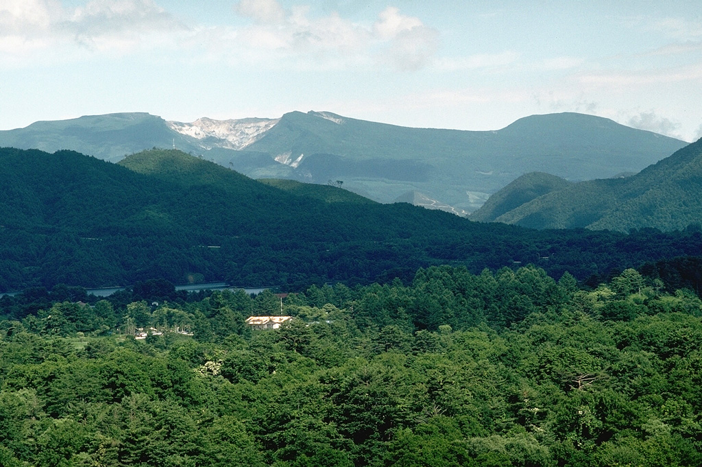
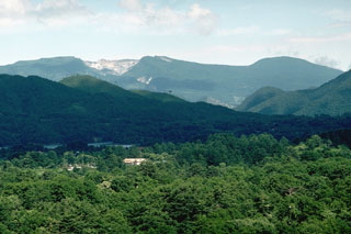 The broad Adatara massif is composed of a group of cones and lava domes, seen here from the W. The unvegetated area on the left summit ridge is a 1-km-wide circular crater that has been mined for sulfur. Seventy-two miners working in the crater were killed during an explosive eruption in 1900.