Earthquake swarm ends in mid-October
As reported in BGVN 20:09, on 6 October a M 5.6 earthquake occurred adjacent to Kozu-shima and a seismic swarm followed for the next few days. After that, seismic events continued but decreased toward the end of October; in total, during October there were 246 felt earthquakes.
Information Contacts: Volcanological Division, Seismological and Volcanological Department, Japan Meteorological Agency (JMA), 1-3-4 Ote-machi, Chiyoda-ku, Tokyo 100 Japan.
The Global Volcanism Program has no Weekly Reports available for Kozushima.
Reports are organized chronologically and indexed below by Month/Year (Publication Volume:Number), and include a one-line summary. Click on the index link or scroll down to read the reports.
Earthquake swarm but no surface activity
An earthquake swarm (M <= 4.0) occurred from 2100 to 2400 on 23 April, with seismicity gradually returning to normal levels by the following day. Many of the earthquakes were felt by residents (to JMA intensity IV). Swarm events were centered from the W coast to 20 km SW of the island (figure 1), at 0-10 km depth. No surface activity was reported.
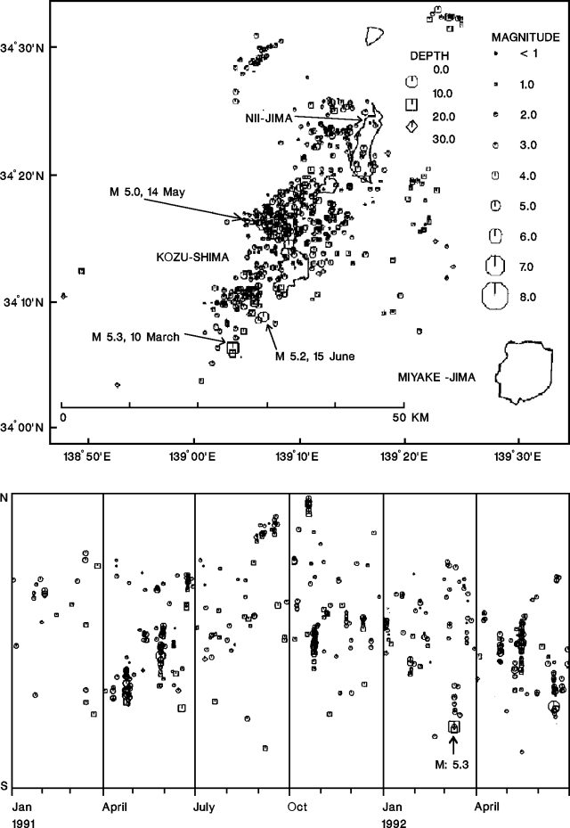 |
Figure 1. Epicenter map (top) and space/time diagram (bottom) showing seismicity around Kozu-shima and Nii-jima volcanoes, January 1991-June 1992. Courtesy of JMA. |
Information Contacts: JMA.
Earthquake swarm N of island
An earthquake swarm occurred 24-25 October in the sea 7 km N of Kozu-shima (figure 1). The largest shocks (M 4.9) were recorded at 1746 and 1754 on the 24th. Changes in surface activity were not observed on the island or in the epicentral area. The seismicity was the first for the area since 23 April . . . .
Information Contacts: JMA.
Earthquake swarm follows nearby Nii-jima seismicity; no surface activity observed
On 26-27 January, three weeks after an earthquake swarm centered ~10 km NE of the volcano, another swarm was recorded a few kilometers E of Kozu-shima (figure 1). The 26-27 January swarm's two largest shocks, M 3.3, occurred at 2041 and 2050 on the 26th. No surface activity was observed.
Information Contacts: JMA.
Two seismic swarms; no surface changes evident
A seismic swarm occurred 21-25 April, centered a few kilometers NW of the island. Some of the shocks were felt by island residents; the largest, M 3.6, occurred on 23 April. Another swarm was recorded on 8 May, centered E of the island (maximum M 3.9). No surface anomalies were observed.
Information Contacts: JMA.
Continued seismic swarms
Abnormal seismicity continued around the volcano in May, when 2 earthquake swarms were recorded. On 8 May a swarm occurred 2-3 km E of the island, with M <3.9. The second, on 14-16 May, occurred 3-4 km NW, with the largest event (M 4.9) recorded at 0731 on 15 May. No surface anomalies were observed.
Information Contacts: JMA.
Earthquake and aftershocks
A M 5.2 earthquake, centered in the sea 8 km SW of the volcano at 9 km depth, occurred on 15 June at 1046. Island residents felt the shock at intensity 5 on the JMA scale of 0-7. Data from 30 stations of the Worldwide Standardized Seismic Network yielded magnitudes of 4.9 (mb) and 4.7 (Ms). One person was slightly injured by a rockfall, and wallrock collapse at 10 sites closed 5 roads to traffic. Aftershocks continued until 17 June off the island's SW coast. The event was the second largest since . . . April 1991 (figure 1). No surface anomalies were observed on the island or on the sea-surface nearby.
Information Contacts: JMA; NEIC.
Weak seismic swarm; surface activity unchanged
A weak earthquake swarm was detected 5 km NE of the volcano island on 18 August. Maximum magnitude was 3.0. No surface activity was evident on the island or in the sea.
Information Contacts: JMA.
Weak earthquake swarm
A weak earthquake swarm occurred 5 km W of the island on 1 September. Maximum magnitude was 2.1. No surface activity was evident on the island or in the sea.
Information Contacts: JMA.
Earthquake swarm but no surface changes evident
A swarm of earthquakes occurred midway between [Nii-jima and Kozu-shima] islands 17-20 October. The largest earthquake was M 5.1, at 2237 on 17 October. No ocean-surface anomalies were observed.
Information Contacts: JMA.
Earthquake swarm on 25 March; no surface anomalies
. . . On 25 March, a swarm occurred at Kozu-shima island, ~20 km SW of Nii-jima. The largest event was M 3.9. No surface anomalies, onshore or offshore, were observed . . . .
Information Contacts: JMA.
Earthquake swarms
An earthquake swarm near and below Kozu-shima island occurred on 9-10 August, with 12 shocks felt on the island, the largest M 3.3. Another earthquake near the island, M 3.7, occurred in the early morning on 22 August.
Information Contacts: JMA.
Strong earthquake swarm in early October
At 2143 on 6 October, a M 5.6 earthquake occurred near Kozu-shima (figure 2). The earthquake, which had an intensity at Kozu-shima of V on JMA's scale, caused a few landslides there. A M 4.8 earthquake 14 minutes earlier had an intensity of IV. During the next several days, an earthquake swarm continued offshore to the SW of Kozu-shima (figure 2, bottom). The swarm's maximum depth shifted downward with time, reaching 20-25 km. None of this seismicity was thought to have been induced by volcanism.
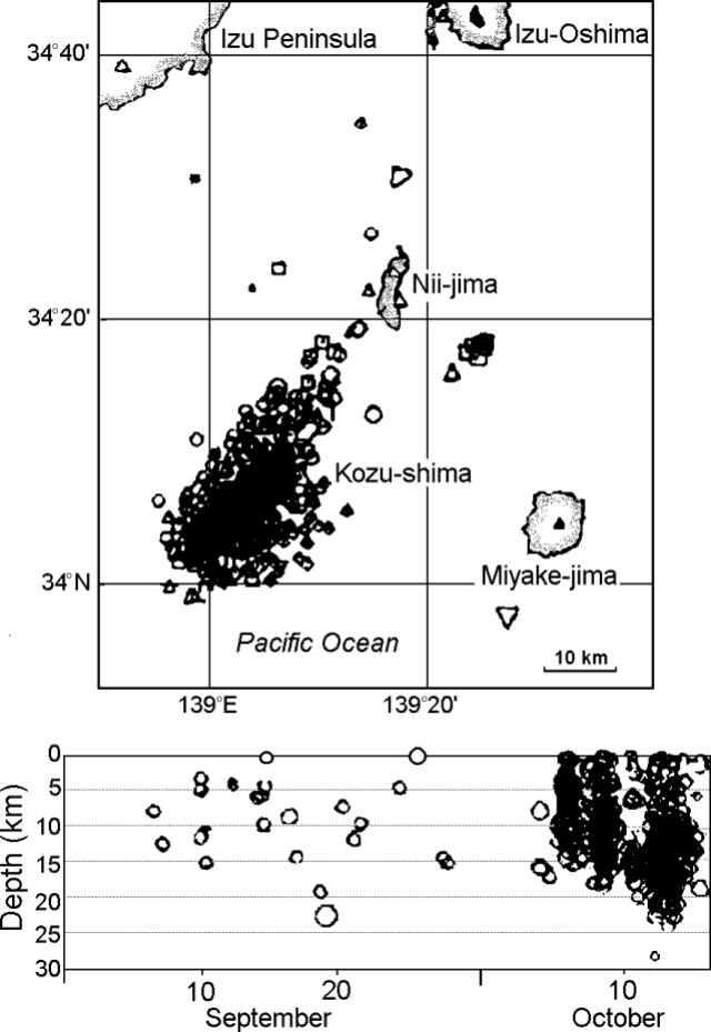 |
Figure 2. Kozu-shima epicenter map (top) and plot of focal depths versus time for September through 16 October 1995 (bottom). Courtesy of JMA. |
Though obscured by epicenters on figure 2, Kozu-shima island has dimensions of 4 x 6 km and lies 20 km SSW of Nii-jima island and adjacent to the Izu Peninsula. Kozu-shima contains abundant rhyolitic surge deposits and lava domes. Its last eruption was in 838-840 AD. Seismicity near the volcano, and sometimes in vicinity of Nii-jima, has been episodically high in recent years.
Information Contacts: Volcanological Division, Seismological and Volcanological Department, Japan Meteorological Agency (JMA), 1-3-4 Ote-machi, Chiyoda-ku, Tokyo 100 Japan.
Earthquake swarm ends in mid-October
As reported in BGVN 20:09, on 6 October a M 5.6 earthquake occurred adjacent to Kozu-shima and a seismic swarm followed for the next few days. After that, seismic events continued but decreased toward the end of October; in total, during October there were 246 felt earthquakes.
Information Contacts: Volcanological Division, Seismological and Volcanological Department, Japan Meteorological Agency (JMA), 1-3-4 Ote-machi, Chiyoda-ku, Tokyo 100 Japan.
|
|
||||||||||||||||||||||||||
There is data available for 4 confirmed eruptive periods.
0838 Aug 2 (?) Confirmed Eruption (Explosive / Effusive) VEI: 4
| Episode 1 | Eruption (Explosive / Effusive) | Tenjo-san | ||||||||||||||||||||||||||||||||||||||||||||||||
|---|---|---|---|---|---|---|---|---|---|---|---|---|---|---|---|---|---|---|---|---|---|---|---|---|---|---|---|---|---|---|---|---|---|---|---|---|---|---|---|---|---|---|---|---|---|---|---|---|---|
| 0838 Aug 2 (?) - Unknown | Evidence from Observations: Reported | ||||||||||||||||||||||||||||||||||||||||||||||||
|
List of 8 Events for Episode 1 at Tenjo-san
|
|||||||||||||||||||||||||||||||||||||||||||||||||
[ 0832 ] Uncertain Eruption
| Episode 1 | Eruption (Explosive / Effusive) | |||||||||||||||||||
|---|---|---|---|---|---|---|---|---|---|---|---|---|---|---|---|---|---|---|---|
| 0832 - Unknown | Evidence from Unknown | ||||||||||||||||||
|
List of 2 Events for Episode 1
|
|||||||||||||||||||
0100 BCE ± 950 years Confirmed Eruption (Explosive / Effusive)
| Episode 1 | Eruption (Explosive / Effusive) | NW tip of island (Kobe-yama) | ||||||||||||||||||
|---|---|---|---|---|---|---|---|---|---|---|---|---|---|---|---|---|---|---|---|
| 0100 BCE ± 950 years - Unknown | Evidence from Chem/Bio: Hydration Rind | ||||||||||||||||||
|
List of 2 Events for Episode 1 at NW tip of island (Kobe-yama)
|
|||||||||||||||||||
0750 BCE ± 700 years Confirmed Eruption (Explosive / Effusive)
| Episode 1 | Eruption (Explosive / Effusive) | N tip of island (Anano-yama, Hanatabe) | ||||||||||||||||||
|---|---|---|---|---|---|---|---|---|---|---|---|---|---|---|---|---|---|---|---|
| 0750 BCE ± 700 years - Unknown | Evidence from Chem/Bio: Hydration Rind | ||||||||||||||||||
|
List of 2 Events for Episode 1 at N tip of island (Anano-yama, Hanatabe)
|
|||||||||||||||||||
8050 BCE (?) Confirmed Eruption (Explosive / Effusive)
| Episode 1 | Eruption (Explosive / Effusive) | Jogo-yama | |||||||||||||
|---|---|---|---|---|---|---|---|---|---|---|---|---|---|---|
| 8050 BCE (?) - Unknown | Evidence from Correlation: Tephrochronology | |||||||||||||
|
List of 1 Events for Episode 1 at Jogo-yama
|
||||||||||||||
This compilation of synonyms and subsidiary features may not be comprehensive. Features are organized into four major categories: Cones, Craters, Domes, and Thermal Features. Synonyms of features appear indented below the primary name. In some cases additional feature type, elevation, or location details are provided.
Synonyms |
||||
| Kozu-sima | Kozu-shima | ||||
Domes |
||||
| Feature Name | Feature Type | Elevation | Latitude | Longitude |
| Anano-yama
Anagi-yama |
Dome | |||
| Hanatate | Dome | |||
| Jogo-yama
Zyogoro-yama |
Dome | |||
| Kobe-yama | Dome | 270 m | ||
| Matsuyamahana | Dome | |||
| Osawa | Dome | |||
| Takado-yama | Dome | 304 m | ||
| Tenjosan
Tenzyo-san Tenjo-san Tenjoyama |
Dome | 574 m | 34° 12' 58.00" N | 139° 9' 23.00" E |
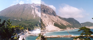 Tenjo lava dome, in the central part of the island of Kozushima, was formed during an eruption in 838 CE. Formation of the rhyolitic lava dome was accompanied by pyroclastic flows and surges and the extrusion of flow-banded lava flows.
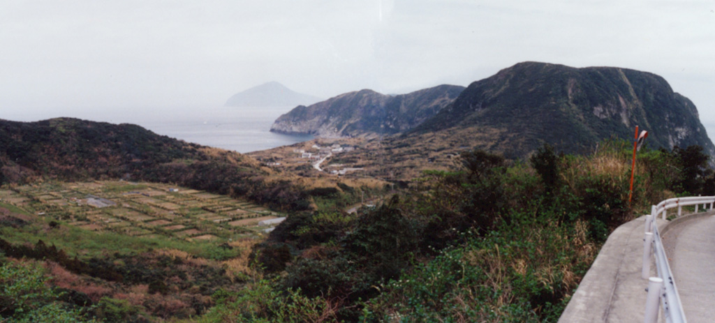
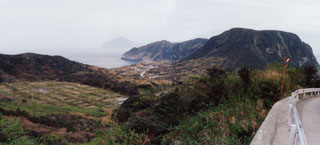 The agricultural area on floor of an explosion crater (left) and a flat-topped lava dome (right) are part of Kozushima volcano in the northern Izu Islands. The small 4 x 6 km island formed by a cluster of rhyolitic lava domes and associated pyroclastic deposits. The youngest and largest dome, Tenjoyama, occupies the central portion of the island. Most of the older domes are to the north. Two historical eruptions occurred during the 9th century.
There are no samples for Kozushima in the Smithsonian's NMNH Department of Mineral Sciences Rock and Ore collection.
| Copernicus Browser | The Copernicus Browser replaced the Sentinel Hub Playground browser in 2023, to provide access to Earth observation archives from the Copernicus Data Space Ecosystem, the main distribution platform for data from the EU Copernicus missions. |
| MIROVA | Middle InfraRed Observation of Volcanic Activity (MIROVA) is a near real time volcanic hot-spot detection system based on the analysis of MODIS (Moderate Resolution Imaging Spectroradiometer) data. In particular, MIROVA uses the Middle InfraRed Radiation (MIR), measured over target volcanoes, in order to detect, locate and measure the heat radiation sourced from volcanic activity. |
| MODVOLC Thermal Alerts | Using infrared satellite Moderate Resolution Imaging Spectroradiometer (MODIS) data, scientists at the Hawai'i Institute of Geophysics and Planetology, University of Hawai'i, developed an automated system called MODVOLC to map thermal hot-spots in near real time. For each MODIS image, the algorithm automatically scans each 1 km pixel within it to check for high-temperature hot-spots. When one is found the date, time, location, and intensity are recorded. MODIS looks at every square km of the Earth every 48 hours, once during the day and once during the night, and the presence of two MODIS sensors in space allows at least four hot-spot observations every two days. Each day updated global maps are compiled to display the locations of all hot spots detected in the previous 24 hours. There is a drop-down list with volcano names which allow users to 'zoom-in' and examine the distribution of hot-spots at a variety of spatial scales. |
|
WOVOdat
Single Volcano View Temporal Evolution of Unrest Side by Side Volcanoes |
WOVOdat is a database of volcanic unrest; instrumentally and visually recorded changes in seismicity, ground deformation, gas emission, and other parameters from their normal baselines. It is sponsored by the World Organization of Volcano Observatories (WOVO) and presently hosted at the Earth Observatory of Singapore.
GVMID Data on Volcano Monitoring Infrastructure The Global Volcano Monitoring Infrastructure Database GVMID, is aimed at documenting and improving capabilities of volcano monitoring from the ground and space. GVMID should provide a snapshot and baseline view of the techniques and instrumentation that are in place at various volcanoes, which can be use by volcano observatories as reference to setup new monitoring system or improving networks at a specific volcano. These data will allow identification of what monitoring gaps exist, which can be then targeted by remote sensing infrastructure and future instrument deployments. |
| Volcanic Hazard Maps | The IAVCEI Commission on Volcanic Hazards and Risk has a Volcanic Hazard Maps database designed to serve as a resource for hazard mappers (or other interested parties) to explore how common issues in hazard map development have been addressed at different volcanoes, in different countries, for different hazards, and for different intended audiences. In addition to the comprehensive, searchable Volcanic Hazard Maps Database, this website contains information about diversity of volcanic hazard maps, illustrated using examples from the database. This site is for educational purposes related to volcanic hazard maps. Hazard maps found on this website should not be used for emergency purposes. For the most recent, official hazard map for a particular volcano, please seek out the proper institutional authorities on the matter. |
| IRIS seismic stations/networks | Incorporated Research Institutions for Seismology (IRIS) Data Services map showing the location of seismic stations from all available networks (permanent or temporary) within a radius of 0.18° (about 20 km at mid-latitudes) from the given location of Kozushima. Users can customize a variety of filters and options in the left panel. Note that if there are no stations are known the map will default to show the entire world with a "No data matched request" error notice. |
| UNAVCO GPS/GNSS stations | Geodetic Data Services map from UNAVCO showing the location of GPS/GNSS stations from all available networks (permanent or temporary) within a radius of 20 km from the given location of Kozushima. Users can customize the data search based on station or network names, location, and time window. Requires Adobe Flash Player. |
| DECADE Data | The DECADE portal, still in the developmental stage, serves as an example of the proposed interoperability between The Smithsonian Institution's Global Volcanism Program, the Mapping Gas Emissions (MaGa) Database, and the EarthChem Geochemical Portal. The Deep Earth Carbon Degassing (DECADE) initiative seeks to use new and established technologies to determine accurate global fluxes of volcanic CO2 to the atmosphere, but installing CO2 monitoring networks on 20 of the world's 150 most actively degassing volcanoes. The group uses related laboratory-based studies (direct gas sampling and analysis, melt inclusions) to provide new data for direct degassing of deep earth carbon to the atmosphere. |
| Large Eruptions of Kozushima | Information about large Quaternary eruptions (VEI >= 4) is cataloged in the Large Magnitude Explosive Volcanic Eruptions (LaMEVE) database of the Volcano Global Risk Identification and Analysis Project (VOGRIPA). |
| EarthChem | EarthChem develops and maintains databases, software, and services that support the preservation, discovery, access and analysis of geochemical data, and facilitate their integration with the broad array of other available earth science parameters. EarthChem is operated by a joint team of disciplinary scientists, data scientists, data managers and information technology developers who are part of the NSF-funded data facility Integrated Earth Data Applications (IEDA). IEDA is a collaborative effort of EarthChem and the Marine Geoscience Data System (MGDS). |

